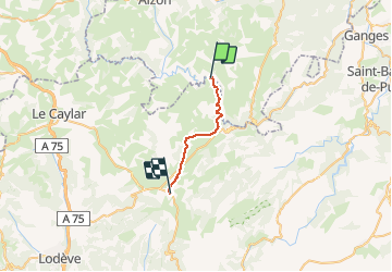
![](/images/other/stat-length.png)
![Tocht Stappen Saint-Maurice-Navacelles - GR7 E16 MasGuillou-LaVacquerie - Photo](https://media.geolcdn.com/t/1900/400/ext.pjpeg?maxdim=2&url=https%3A%2F%2Fstatic1.geolcdn.com%2Fsiteimages%2Fupload%2Ffiles%2F1553511878bg_sport_marche.png)
GR7 E16 MasGuillou-LaVacquerie
richard21220
Gebruiker
![Lengte](/images/other/stat-length.png)
![Max. hoogte](https://static1.geolcdn.com/siteimages/upload/files/1508320355ic_sort_altitude_max_24dp.png)
![Positief hoogteverschil](https://static1.geolcdn.com/siteimages/upload/files/1508320355ic_sort_den_pos_24dp.png)
![Km-Effort](/images/other/stat-length.png)
![Min. hoogte](https://static1.geolcdn.com/siteimages/upload/files/1508320355ic_sort_altitude_min_24dp.png)
![Negatief hoogteverschil](https://static1.geolcdn.com/siteimages/upload/files/1508320355ic_sort_den_neg_24dp.png)
![Boucle](https://static1.geolcdn.com/siteimages/upload/files/16400158638029165_repeat_loop_refresh_sync_direction_icon.png)
![Stappen](https://static1.geolcdn.com/sitytour/trail-icons/101.png)
5h38
Moeilijkheid : Gemakkelijk
![Scan deze QR-code om de tocht te openen in de SityTrail-applicatie](https://capi.geolives.com/qq0zvz2zws4bq2lad0pu/sitytour/trails/680803/qr.png?size=200)
Gratisgps-wandelapplicatie
Over ons
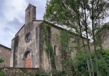
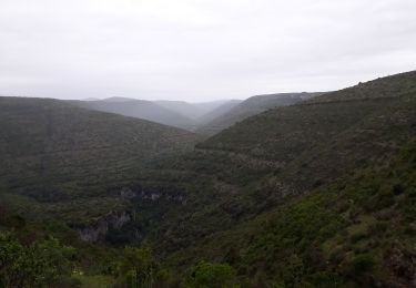
Tocht Stappen van 17,6 km beschikbaar op Occitanië, Hérault, Saint-Maurice-Navacelles. Deze tocht wordt voorgesteld door richard21220.
Beschrijving
Auberge des Causses Le Zibardi : Le Village 34520 LA VACQUERIE ET SAINT MARTIN DE CASTRIE Tél 04 67 95 16 88
Gîte d'Etape Pouss'Combe : Le village 34520 LA VACQUERIE ET SAINT MARTIN DE CASTRIE Tél 04 67 44 68 99
Gîte d'Etape du Club Alpin Français : Le Village 34520 LA VACQUERIE ET SAINT MARTIN DE CASTRIE Tél 04 67 95 16 88
Chambres d'Hôtes Le Relais Des Faïsses : le Faïsses 34520 LA VACQUERIE ET SAINT MARTIN DE CASTRIE Tél 04 67 44 64 06
Plaatsbepaling
Opmerkingen
Wandeltochten in de omgeving
![Tocht Stappen Saint-Maurice-Navacelles - cirque de Navacelles - Photo](https://media.geolcdn.com/t/375/260/ext.jpg?maxdim=2&url=https%3A%2F%2Fservices.sitytrail.com%2FGeolivesWS%2FDownloadMedia.ashx%3FTrailID%3D331316%26Media%3D20140805152414.jpg)
![Stappen Stappen](https://static1.geolcdn.com/sitytour/trail-icons/101.png)
Stappen
![](/images/other/stat-length.png)
![](https://static1.geolcdn.com/siteimages/upload/files/16400158638029165_repeat_loop_refresh_sync_direction_icon.png)
![Tocht Stappen Rogues - Madières - La Sauvie - Photo](https://media.geolcdn.com/t/375/260/ext.jpg?maxdim=2&url=https%3A%2F%2Fservices.sitytrail.com%2FGeolivesWS%2FDownloadMedia.ashx%3FTrailID%3D214916%26Media%3D15483_6.jpg)
![Stappen Stappen](https://static1.geolcdn.com/sitytour/trail-icons/101.png)
Stappen
![](/images/other/stat-length.png)
![](https://static1.geolcdn.com/siteimages/upload/files/16400158638029165_repeat_loop_refresh_sync_direction_icon.png)
![Tocht Stappen Vissec - sentier du Regagnas - Photo](https://media.geolcdn.com/t/375/260/da6617d7-2a0d-4d03-9eaa-131f37014f58.jpg&format=jpg&maxdim=2)
![Stappen Stappen](https://static1.geolcdn.com/sitytour/trail-icons/101.png)
Stappen
![](/images/other/stat-length.png)
![](https://static1.geolcdn.com/siteimages/upload/files/16400158638029165_repeat_loop_refresh_sync_direction_icon.png)
![Tocht Te voet Saint-Maurice-Navacelles - Navacelles Vissec par le chemin du facteur - Photo](https://media.geolcdn.com/t/375/260/5eb51299-e303-4e2d-9d78-ac9fc254c62c.jpeg&format=jpg&maxdim=2)
![Te voet Te voet](https://static1.geolcdn.com/sitytour/trail-icons/100.png)
Te voet
![](/images/other/stat-length.png)
![](https://static1.geolcdn.com/siteimages/upload/files/16400158638029165_repeat_loop_refresh_sync_direction_icon.png)
![Tocht Te voet Blandas - Randonnée Cirque de Navacelles - Causse de Blandas - Vissec - Moulin de la Foux - Photo](https://media.geolcdn.com/t/375/260/8ddb3d2c-f886-47a1-a994-79ae500f0ce8.jpeg&format=jpg&maxdim=2)
![Te voet Te voet](https://static1.geolcdn.com/sitytour/trail-icons/100.png)
Te voet
![](/images/other/stat-length.png)
![](https://static1.geolcdn.com/siteimages/upload/files/16400158638029165_repeat_loop_refresh_sync_direction_icon.png)
![Tocht Stappen Blandas - Causse de Blandas et Vallée de la Vis - Photo](https://media.geolcdn.com/t/375/260/63d6e02c-c419-4b36-9d67-d9ec414c30bc.jpg&format=jpg&maxdim=2)
![Stappen Stappen](https://static1.geolcdn.com/sitytour/trail-icons/101.png)
Stappen
![](/images/other/stat-length.png)
![](https://static1.geolcdn.com/siteimages/upload/files/16400158638029165_repeat_loop_refresh_sync_direction_icon.png)
![Tocht Stappen Blandas - Vissec / Moulin de la Foux - Photo](https://media.geolcdn.com/t/375/260/10a13c13-90e1-488e-8e53-bc3d65b1bc36.jpg&format=jpg&maxdim=2)
![Stappen Stappen](https://static1.geolcdn.com/sitytour/trail-icons/101.png)
Stappen
![](/images/other/stat-length.png)
![](https://static1.geolcdn.com/siteimages/upload/files/16400158638029165_repeat_loop_refresh_sync_direction_icon.png)
![Tocht Stappen Blandas - Bois de calot rouge - Photo](https://media.geolcdn.com/t/375/260/a9a713a3-ac0f-45b3-9482-9c5a24bfa783.jpg&format=jpg&maxdim=2)
![Stappen Stappen](https://static1.geolcdn.com/sitytour/trail-icons/101.png)
Stappen
![](/images/other/stat-length.png)
![](https://static1.geolcdn.com/siteimages/upload/files/16400158638029165_repeat_loop_refresh_sync_direction_icon.png)
![Tocht Stappen Blandas - Sentier du Belvédère de Blandas 2 - Photo](https://media.geolcdn.com/t/375/260/ext.jpg?maxdim=2&url=https%3A%2F%2Fstatic1.geolcdn.com%2Fsiteimages%2Fupload%2Ffiles%2F1553511878bg_sport_marche.png)
![Stappen Stappen](https://static1.geolcdn.com/sitytour/trail-icons/101.png)
Stappen
![](/images/other/stat-length.png)
![](https://static1.geolcdn.com/siteimages/upload/files/16400158638029165_repeat_loop_refresh_sync_direction_icon.png)