Tocht Andere activiteiten Pavilly - Haute - Normandie - Ligne 351 - Barentin - Caudebec-en-Caux - Photo

Haute - Normandie - Ligne 351 - Barentin - Caudebec-en-Caux

 mich54
mich54

Gebruiker

© OpenStreetMap contributors
Lengte
Lengte
26 km
Max. hoogte
Max. hoogte
76 m
Positief hoogteverschil
226 m
Km-Effort
Km-Effort  
29 km
Min. hoogte
Min. hoogte
2 m
Negatief hoogteverschil
287 m
Boucle
Boucle
Neen
Datum van aanmaak :
2016-12-20 00:00:00.0
Laatste wijziging :
2016-12-20 00:00:00.0

(0 Bericht)

Andere activiteiten
Andere activiteiten
5m
Moeilijkheid : Onbekend

Scan deze QR-code om de tocht te openen in de SityTrail-applicatie

Gratisgps-wandelapplicatie

Logo SityTrail SityTrail

IGN / Geografische instituten

SityTrail uit de App Store downloaden SityTrail uit Google Play downloaden

Logo SityTrail SityTrail World

De wereld gaat voor u open

SityTrail uit de App Store downloaden SityTrail uit Google Play downloaden SityTrail op Huawei AppGallery downloaden

Over ons

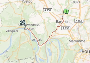
Tocht Andere activiteiten van 26 km beschikbaar op Normandië, Seine-Maritime, Pavilly. Deze tocht wordt voorgesteld door mich54.

Beschrijving

La ligne de Barentin à Caudebec-en-Caux est une voie ferrée française à écartement standard, sise dans le département de Seine-Inférieure (aujourd'hui Seine-Maritime), établie par la Compagnie des chemins de fer de l'Ouest. Inauguré en deux étapes, en 1881 et 1882, ce chemin de fer fut fermé aux voyageurs en 1949, puis aux marchandises en 1990. Cette ligne peut être considérée comme une antenne de la grande radiale Paris-Le Havre desservant à partir de la gare de Barentin les communes à vocation industrielle situées sur la rive droite de la Seine.

Elle constitue la ligne 351 0001 du réseau ferré national.(Source Wikipédia)

Hoogteprofiel

Plaatsbepaling

Land:
France
Regio :
Normandië
Departement/Provincie :
Seine-Maritime
Gemeente :
Pavilly
Locatie:
Unknown
Vertrek:(Dec)
Vertrek:(UTM)
351900 ; 5491984 (31U) N.

Wandeltochten in de omgeving

Tocht Stappen Pavilly - 076-90-Pavilly / St Autreberthe  13.5km - Photo
Stappen
rvs147

Stappen

Medium
(1)
Pavilly, Normandië, Seine-Maritime, France
12 km | 15 km-effort
3h 23min
Ja
Tocht Stappen Barentin - 20221006-Barentin  - Photo
Stappen
doudet

Stappen

Medium
Barentin, Normandië, Seine-Maritime, France
13,7 km | 16,1 km-effort
3h 40min
Ja
Tocht Stappen Pavilly - 20220203-Pavilly - Photo
Stappen
doudet

Stappen

Medium
Pavilly, Normandië, Seine-Maritime, France
12,1 km | 15 km-effort
3h 36min
Ja
Tocht Stappen Pavilly - Pavilly St. Austreberthe (51) - Photo
Stappen
randovivi

Stappen

Gemakkelijk
(2)
Pavilly, Normandië, Seine-Maritime, France
10,3 km | 13 km-effort
2h 49min
Ja
Tocht Stappen Barentin - barentin balades contées oeuvres sreet art  - Photo
Stappen
nicole.reine@wanadoo.fr

Stappen

Gemakkelijk
Barentin, Normandië, Seine-Maritime, France
1,9 km | 2,1 km-effort
2h 17min
Neen
Tocht Stappen Goupillières - Goupillieres 6 - Photo
Stappen
francois duparc

Stappen

Gemakkelijk
Goupillières, Normandië, Seine-Maritime, France
6,8 km | 7,6 km-effort
1h 40min
Ja
Tocht Te voet Hugleville-en-Caux - Le Bois de Grofys - Photo
Te voet
GUIDE+

Te voet

Gemakkelijk
Hugleville-en-Caux, Normandië, Seine-Maritime, France
11,6 km | 13,3 km-effort
3h 1min
Ja
Tocht Te voet Pavilly - 2020-01-22_15h00m10_20200125-pavilly - Photo
Te voet
rvs147

Te voet

Heel gemakkelijk
Pavilly, Normandië, Seine-Maritime, France
13 km | 16 km-effort
Onbekend
Ja
Tocht Stappen Sainte-Austreberthe - Ste Austreberthe Pavilly A-R - Photo
Stappen
MichelARRP

Stappen

Moeilijk
Sainte-Austreberthe, Normandië, Seine-Maritime, France
12,5 km | 15,6 km-effort
3h 7min
Ja


Sluiten
Mijn abonnementen