![](/images/other/stat-length.png)
![Tocht Stappen Tautavel - Tautavel - Tour Del Far - Photo](https://media.geolcdn.com/t/1900/400/ext.pjpeg?maxdim=2&url=https%3A%2F%2Fstatic1.geolcdn.com%2Fsiteimages%2Fupload%2Ffiles%2F1553511878bg_sport_marche.png)
Tautavel - Tour Del Far
ThonyM
Gebruiker
![Lengte](/images/other/stat-length.png)
Lengte
71 km
![Max. hoogte](https://static1.geolcdn.com/siteimages/upload/files/1508320355ic_sort_altitude_max_24dp.png)
Max. hoogte
481 m
![Positief hoogteverschil](https://static1.geolcdn.com/siteimages/upload/files/1508320355ic_sort_den_pos_24dp.png)
Positief hoogteverschil
1485 m
![Km-Effort](/images/other/stat-length.png)
Km-Effort
90 km
![Min. hoogte](https://static1.geolcdn.com/siteimages/upload/files/1508320355ic_sort_altitude_min_24dp.png)
Min. hoogte
51 m
![Negatief hoogteverschil](https://static1.geolcdn.com/siteimages/upload/files/1508320355ic_sort_den_neg_24dp.png)
Negatief hoogteverschil
1254 m
![Boucle](https://static1.geolcdn.com/siteimages/upload/files/16400158638029165_repeat_loop_refresh_sync_direction_icon.png)
Boucle
Neen
Datum van aanmaak :
2016-12-08 00:00:00.0
Laatste wijziging :
2016-12-08 00:00:00.0
![Stappen](https://static1.geolcdn.com/sitytour/trail-icons/101.png)
5h53
Moeilijkheid : Medium
![Scan deze QR-code om de tocht te openen in de SityTrail-applicatie](https://capi.geolives.com/qq0zvz2zws4bq2lad0pu/sitytour/trails/669969/qr.png?size=200)
Gratisgps-wandelapplicatie
Over ons
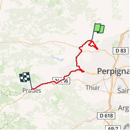
Tocht Stappen van 71 km beschikbaar op Occitanië, Pyrénées-Orientales, Tautavel. Deze tocht wordt voorgesteld door ThonyM.
Beschrijving
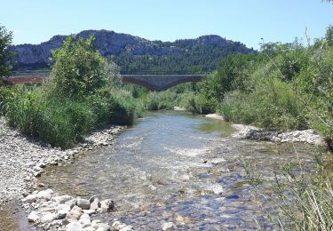
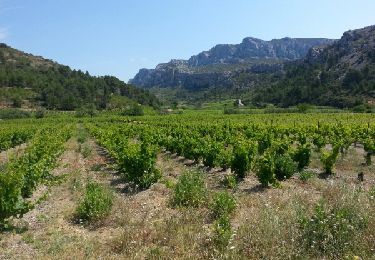
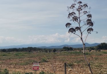
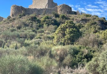
Une randonnée DNS le brouillard mais quand même agréable. Pas de difficulté majeure. Attention Xu pierres et racines glissantes par temps de pluie ou de brouillard
Plaatsbepaling
Land:
France
Regio :
Occitanië
Departement/Provincie :
Pyrénées-Orientales
Gemeente :
Tautavel
Locatie:
Unknown
Vertrek:(Dec)
Vertrek:(UTM)
479649 ; 4740655 (31T) N.
Opmerkingen
Wandeltochten in de omgeving
![Tocht Stappen Tautavel - Tautavel chemin des bacs - Photo](https://media.geolcdn.com/t/375/260/4347d338-087b-4ab9-a23d-b90780ad37c2.jpg&format=jpg&maxdim=2)
![Stappen Stappen](https://static1.geolcdn.com/sitytour/trail-icons/101.png)
Tautavel chemin des bacs
Stappen
Gemakkelijk
(3)
Tautavel,
Occitanië,
Pyrénées-Orientales,
France
![](/images/other/stat-length.png)
9,5 km | 12,4 km-effort
2h 30min
![](https://static1.geolcdn.com/siteimages/upload/files/16400158638029165_repeat_loop_refresh_sync_direction_icon.png)
Ja
![Tocht Stappen Vingrau - Chemin des Contrebandiers Vingrau variante - Photo](https://media.geolcdn.com/t/375/260/ext.jpg?maxdim=2&url=https%3A%2F%2Fservices.sitytrail.com%2FGeolivesWS%2FDownloadMedia.ashx%3FTrailID%3D422545%26Media%3Dfix__20140613113149.jpg)
![Stappen Stappen](https://static1.geolcdn.com/sitytour/trail-icons/101.png)
Chemin des Contrebandiers Vingrau variante
Stappen
Medium
(2)
Vingrau,
Occitanië,
Pyrénées-Orientales,
France
![](/images/other/stat-length.png)
10,4 km | 16 km-effort
3h 30min
![](https://static1.geolcdn.com/siteimages/upload/files/16400158638029165_repeat_loop_refresh_sync_direction_icon.png)
Ja
![Tocht Stappen Vingrau - Vingrau - Photo](https://media.geolcdn.com/t/375/260/59157f3c-9cda-4a07-bd09-42a8a8a018aa.jpg&format=jpg&maxdim=2)
![Stappen Stappen](https://static1.geolcdn.com/sitytour/trail-icons/101.png)
Vingrau
Stappen
Medium
Vingrau,
Occitanië,
Pyrénées-Orientales,
France
![](/images/other/stat-length.png)
15,5 km | 22 km-effort
4h 20min
![](https://static1.geolcdn.com/siteimages/upload/files/16400158638029165_repeat_loop_refresh_sync_direction_icon.png)
Ja
![Tocht Stappen Estagel - ESTAGEL Chapelle St Laurent MARDI FAIT - Photo](https://media.geolcdn.com/t/375/260/14957312-1764-401b-980d-e06b9de6af18.jpg&format=jpg&maxdim=2)
![Stappen Stappen](https://static1.geolcdn.com/sitytour/trail-icons/101.png)
ESTAGEL Chapelle St Laurent MARDI FAIT
Stappen
Medium
(1)
Estagel,
Occitanië,
Pyrénées-Orientales,
France
![](/images/other/stat-length.png)
12,2 km | 16,9 km-effort
3h 26min
![](https://static1.geolcdn.com/siteimages/upload/files/16400158638029165_repeat_loop_refresh_sync_direction_icon.png)
Ja
![Tocht Stappen Cases-de-Pène - 2023-08-01_12h04m36_SityTrail - 3754591 - cases-de-pene-x-detour-et-retour - Photo](https://media.geolcdn.com/t/375/260/883a1714-3990-4d53-92ac-a82da8ee9827.jpg&format=jpg&maxdim=2)
![Stappen Stappen](https://static1.geolcdn.com/sitytour/trail-icons/101.png)
2023-08-01_12h04m36_SityTrail - 3754591 - cases-de-pene-x-detour-et-retour
Stappen
Medium
Cases-de-Pène,
Occitanië,
Pyrénées-Orientales,
France
![](/images/other/stat-length.png)
5 km | 6,1 km-effort
1h 23min
![](https://static1.geolcdn.com/siteimages/upload/files/16400158638029165_repeat_loop_refresh_sync_direction_icon.png)
Ja
![Tocht Stappen Tautavel - les gorges . tautavel par les vignes .. retour par la vallée - Photo](https://media.geolcdn.com/t/375/260/f5cf1c3a-e9df-4e15-9388-551099a87371.jpg&format=jpg&maxdim=2)
![Stappen Stappen](https://static1.geolcdn.com/sitytour/trail-icons/101.png)
les gorges . tautavel par les vignes .. retour par la vallée
Stappen
Gemakkelijk
Tautavel,
Occitanië,
Pyrénées-Orientales,
France
![](/images/other/stat-length.png)
8,2 km | 11 km-effort
2h 57min
![](https://static1.geolcdn.com/siteimages/upload/files/16400158638029165_repeat_loop_refresh_sync_direction_icon.png)
Neen
![Tocht Stappen Paziols - paziols 19 kms - Photo](https://media.geolcdn.com/t/375/260/ddaac51d-e934-4f1b-ab1b-521ca7bf9769.jpg&format=jpg&maxdim=2)
![Stappen Stappen](https://static1.geolcdn.com/sitytour/trail-icons/101.png)
![Tocht Stappen Paziols - Paziols château d’aguilra - Photo](https://media.geolcdn.com/t/375/260/fa47ac32-1f20-4f2f-bc41-046989712c5d.jpg&format=jpg&maxdim=2)
![Stappen Stappen](https://static1.geolcdn.com/sitytour/trail-icons/101.png)
Paziols château d’aguilra
Stappen
Heel gemakkelijk
Paziols,
Occitanië,
Aude,
France
![](/images/other/stat-length.png)
15,1 km | 18,8 km-effort
4h 4min
![](https://static1.geolcdn.com/siteimages/upload/files/16400158638029165_repeat_loop_refresh_sync_direction_icon.png)
Ja
![Tocht Stappen Tautavel - TAUTAVEL la Tour del Far A/R - Photo](https://media.geolcdn.com/t/375/260/7315cb9e-35b2-46c7-8732-adf6f85e9975.jpg&format=jpg&maxdim=2)
![Stappen Stappen](https://static1.geolcdn.com/sitytour/trail-icons/101.png)
TAUTAVEL la Tour del Far A/R
Stappen
Medium
Tautavel,
Occitanië,
Pyrénées-Orientales,
France
![](/images/other/stat-length.png)
6,3 km | 11,4 km-effort
3h 55min
![](https://static1.geolcdn.com/siteimages/upload/files/16400158638029165_repeat_loop_refresh_sync_direction_icon.png)
Ja