Tocht Motor Gauville - RANDO TELETHON 2016 APRES MIDI - Photo

RANDO TELETHON 2016 APRES MIDI

 association
association

Gebruiker

© OpenStreetMap contributors
Lengte
Lengte
73 km
Max. hoogte
Max. hoogte
226 m
Positief hoogteverschil
962 m
Km-Effort
Km-Effort  
86 km
Min. hoogte
Min. hoogte
124 m
Negatief hoogteverschil
963 m
Boucle
Boucle
Ja
Datum van aanmaak :
2016-12-01 00:00:00.0
Laatste wijziging :
2016-12-01 00:00:00.0

(0 Bericht)

Motor
Motor
5h00
Moeilijkheid : Gemakkelijk

Scan deze QR-code om de tocht te openen in de SityTrail-applicatie

Gratisgps-wandelapplicatie

Logo SityTrail SityTrail

IGN / Geografische instituten

SityTrail uit de App Store downloaden SityTrail uit Google Play downloaden

Logo SityTrail SityTrail World

De wereld gaat voor u open

SityTrail uit de App Store downloaden SityTrail uit Google Play downloaden SityTrail op Huawei AppGallery downloaden

Over ons

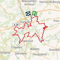
Tocht Motor van 73 km beschikbaar op Hauts-de-France, Somme, Gauville. Deze tocht wordt voorgesteld door association.

Beschrijving

RANDO  TELETHON APRES MIDI 2016

Hoogteprofiel

Plaatsbepaling

Land:
France
Regio :
Hauts-de-France
Departement/Provincie :
Somme
Gemeente :
Gauville
Locatie:
Unknown
Vertrek:(Dec)
Vertrek:(UTM)
413114 ; 5515050 (31U) N.

Wandeltochten in de omgeving

Tocht Te voet Aumale - Le Bois Robin - Photo
Te voet
GUIDE+

Te voet

Gemakkelijk
Aumale, Normandië, Seine-Maritime, France
7,2 km | 8,8 km-effort
1h 59min
Ja
Tocht Te voet Aumale - Le Beau Soleil - Photo
Te voet
GUIDE+

Te voet

Gemakkelijk
Aumale, Normandië, Seine-Maritime, France
9,8 km | 12,2 km-effort
2h 45min
Ja
Tocht Paard Aumale - Le beau soleil N° 2 - Aumale  - Photo
Paard
tracegps

Paard

Medium
Aumale, Normandië, Seine-Maritime, France
10,8 km | 13,4 km-effort
2h 0min
Ja
Tocht Mountainbike Aumale - Le beau soleil N° 2 - Aumale  - Photo
Mountainbike
tracegps

Mountainbike

Medium
Aumale, Normandië, Seine-Maritime, France
10,8 km | 13,4 km-effort
1h 0min
Ja
Tocht Stappen Aumale - Le beau soleil N° 2 - Aumale  - Photo
Stappen
tracegps

Stappen

Medium
Aumale, Normandië, Seine-Maritime, France
10,8 km | 13,4 km-effort
2h 40min
Ja
Tocht Paard Haudricourt - La Lozière (N° 4)  - Haudricourt - Photo
Paard
tracegps

Paard

Medium
Haudricourt, Normandië, Seine-Maritime, France
11 km | 13,9 km-effort
1h 30min
Ja
Tocht Mountainbike Haudricourt - La Lozière (N° 4)  - Haudricourt - Photo
Mountainbike
tracegps

Mountainbike

Gemakkelijk
Haudricourt, Normandië, Seine-Maritime, France
11 km | 13,9 km-effort
1h 0min
Ja
Tocht Stappen Haudricourt - La Lozière (N° 4)  - Haudricourt - Photo
Stappen
tracegps

Stappen

Medium
Haudricourt, Normandië, Seine-Maritime, France
11 km | 13,9 km-effort
2h 45min
Ja
Tocht Paard Aumale - Le bois Robin - Aumale - Photo
Paard
tracegps

Paard

Gemakkelijk
Aumale, Normandië, Seine-Maritime, France
8,4 km | 10,1 km-effort
1h 19min
Ja


Sluiten
Mijn abonnementen