![](/images/other/stat-length.png)
![Tocht Stappen Dormelles - M&R-161124 - Dormelles-PotAuFeu - Photo](https://media.geolcdn.com/t/1900/400/ext.pjpeg?maxdim=2&url=https%3A%2F%2Fservices.sitytrail.com%2FGeolivesWS%2FDownloadMedia.ashx%3FTrailID%3D664290%26Media%3D51203082-027e-4245-84d8-91a3c32300ad.jpg)
M&R-161124 - Dormelles-PotAuFeu
randodan
Gebruiker
![Lengte](/images/other/stat-length.png)
![Max. hoogte](https://static1.geolcdn.com/siteimages/upload/files/1508320355ic_sort_altitude_max_24dp.png)
![Positief hoogteverschil](https://static1.geolcdn.com/siteimages/upload/files/1508320355ic_sort_den_pos_24dp.png)
![Km-Effort](/images/other/stat-length.png)
![Min. hoogte](https://static1.geolcdn.com/siteimages/upload/files/1508320355ic_sort_altitude_min_24dp.png)
![Negatief hoogteverschil](https://static1.geolcdn.com/siteimages/upload/files/1508320355ic_sort_den_neg_24dp.png)
![Boucle](https://static1.geolcdn.com/siteimages/upload/files/16400158638029165_repeat_loop_refresh_sync_direction_icon.png)
![Stappen](https://static1.geolcdn.com/sitytour/trail-icons/101.png)
4h30
Moeilijkheid : Heel gemakkelijk
![Scan deze QR-code om de tocht te openen in de SityTrail-applicatie](https://capi.geolives.com/qq0zvz2zws4bq2lad0pu/sitytour/trails/664290/qr.png?size=200)
Gratisgps-wandelapplicatie
Over ons
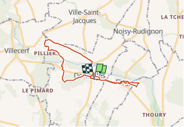
Tocht Stappen van 15,7 km beschikbaar op Île-de-France, Seine-et-Marne, Dormelles. Deze tocht wordt voorgesteld door randodan.
Beschrijving
Rando Pot-au-Feu à Dormelles avec Marche et Rêve<br>
- 24 novembre 2016 - 5e édition.<br>
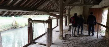
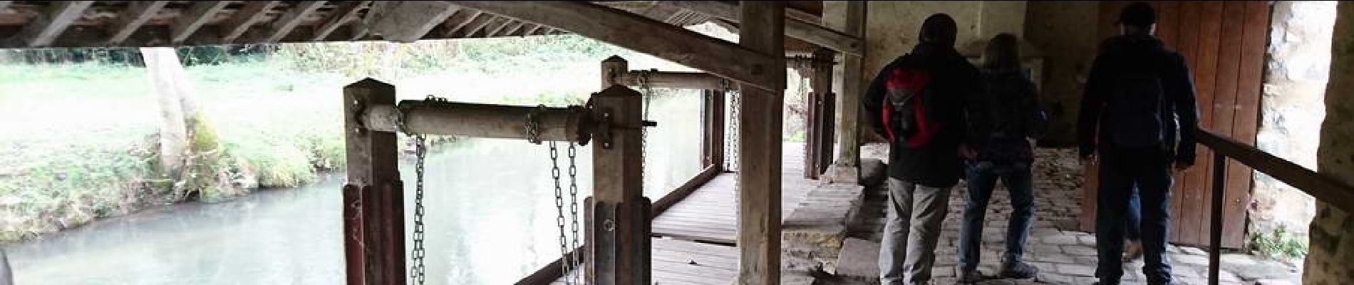
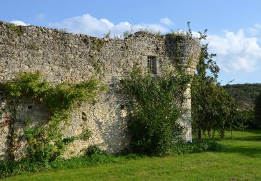
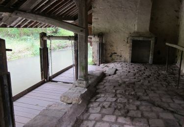
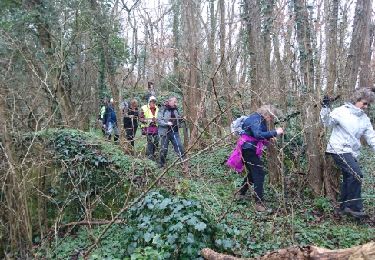
Départ 9h30 du parking de la Salle des Fêtes, mais cette fois, cap au Nord, on descend voir le Lavoir . Place Michel Metreau, on emmanche le GR11 cap à l'Ouest . Il était prévu aller jusqu'à La Fondoire, mais un drone égaré nous ayant retardé, on récupère le GRP de l'Orvanne au Pilier . Le Moulin de la Vallée (Moyen Âge), le Fort de Challeau (13e, 16e), puis la montée au Signal de Montaigu (132 m) et redescente par le Toboggan (mais personne n'a voulu prendre le risque d'abimer son pantalon).<br>
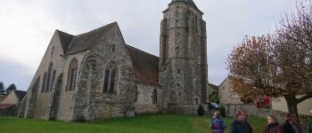
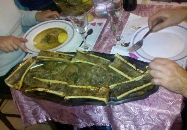
Midi et demi aux voitures pour un changement de chaussures, puis faisons le tour de l'église (12e, 15e) pour arriver, à 13h, à l'Auberge du Bocage ou mijote pot-au-feu et os à moelle . 15h, retournons aux voitures, mais là, nous ne sommes que 7 à rechausser.<br>
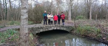
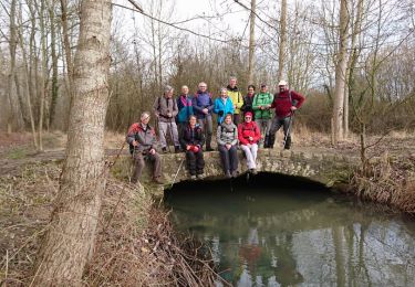
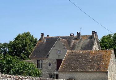
15h20, cap à l'Est pour la visite de Flagy . Tour classique par le petit pont de pierre de l'Aulnoy et retour aux voitures à 16h50.<br>
10 km le matin, mais 16 pour la journée complète.<br>
30 os furent vidés de leur moelle par une journée honnête d'automne avec même un peu de soleil.
Plaatsbepaling
Opmerkingen
Wandeltochten in de omgeving
![Tocht Te voet Villemer - Maquis de Roys - Photo](https://media.geolcdn.com/t/375/260/70e58ce3-920c-43a7-ba54-1d0a3c2796ae.jpeg&format=jpg&maxdim=2)
![Te voet Te voet](https://static1.geolcdn.com/sitytour/trail-icons/100.png)
Te voet
![](/images/other/stat-length.png)
![](https://static1.geolcdn.com/siteimages/upload/files/16400158638029165_repeat_loop_refresh_sync_direction_icon.png)
![Tocht Te voet Ville-Saint-Jacques - Basse vallée de l'Orvanne - Photo](https://media.geolcdn.com/t/375/260/82137b8f-59f6-42a4-8e1b-17c82b952e9a.jpeg&format=jpg&maxdim=2)
![Te voet Te voet](https://static1.geolcdn.com/sitytour/trail-icons/100.png)
Te voet
![](/images/other/stat-length.png)
![](https://static1.geolcdn.com/siteimages/upload/files/16400158638029165_repeat_loop_refresh_sync_direction_icon.png)
![Tocht Noords wandelen Villecerf - Autour de villecerf - Photo](https://media.geolcdn.com/t/375/260/ext.jpg?maxdim=2&url=https%3A%2F%2Fstatic1.geolcdn.com%2Fsiteimages%2Fupload%2Ffiles%2F1545311037marcheuse_200dpi.jpg)
![Noords wandelen Noords wandelen](https://static1.geolcdn.com/sitytour/trail-icons/102.png)
Noords wandelen
![](/images/other/stat-length.png)
![](https://static1.geolcdn.com/siteimages/upload/files/16400158638029165_repeat_loop_refresh_sync_direction_icon.png)
![Tocht Stappen Thoury-Férottes - 180111 EnCours - Photo](https://media.geolcdn.com/t/375/260/ext.jpg?maxdim=2&url=https%3A%2F%2Fservices.sitytrail.com%2FGeolivesWS%2FDownloadMedia.ashx%3FTrailID%3D886916%26Media%3Dfix__20180111125543.jpg)
![Stappen Stappen](https://static1.geolcdn.com/sitytour/trail-icons/101.png)
Stappen
![](/images/other/stat-length.png)
![](https://static1.geolcdn.com/siteimages/upload/files/16400158638029165_repeat_loop_refresh_sync_direction_icon.png)
![Tocht Stappen Thoury-Férottes - Manu-170218 - Thoury-Dormelles - Photo](https://media.geolcdn.com/t/375/260/ext.jpg?maxdim=2&url=https%3A%2F%2Fservices.sitytrail.com%2FGeolivesWS%2FDownloadMedia.ashx%3FTrailID%3D700727%26Media%3D9d381017-48c9-49db-92ae-a1297989025d.jpg)
![Stappen Stappen](https://static1.geolcdn.com/sitytour/trail-icons/101.png)
Stappen
![](/images/other/stat-length.png)
![](https://static1.geolcdn.com/siteimages/upload/files/16400158638029165_repeat_loop_refresh_sync_direction_icon.png)
![Tocht Stappen Dormelles - M&R-141219 - Dormelles - Photo](https://media.geolcdn.com/t/375/260/ext.jpg?maxdim=2&url=https%3A%2F%2Fservices.sitytrail.com%2FGeolivesWS%2FDownloadMedia.ashx%3FTrailID%3D371467%26Media%3D19e6ba95-3c6b-4ae7-8dc3-f0bbed2e93e0.jpg)
![Stappen Stappen](https://static1.geolcdn.com/sitytour/trail-icons/101.png)
Stappen
![](/images/other/stat-length.png)
![](https://static1.geolcdn.com/siteimages/upload/files/16400158638029165_repeat_loop_refresh_sync_direction_icon.png)
![Tocht Stappen Dormelles - M&R-131210 - Dormelles - Photo](https://media.geolcdn.com/t/375/260/ext.jpg?maxdim=2&url=https%3A%2F%2Fservices.sitytrail.com%2FGeolivesWS%2FDownloadMedia.ashx%3FTrailID%3D237422%26Media%3Dfix__20131210110652.jpg)
![Stappen Stappen](https://static1.geolcdn.com/sitytour/trail-icons/101.png)
Stappen
![](/images/other/stat-length.png)
![](https://static1.geolcdn.com/siteimages/upload/files/16400158638029165_repeat_loop_refresh_sync_direction_icon.png)
![Tocht Noords wandelen Villecerf - Autour de Villecerf - Photo](https://media.geolcdn.com/t/375/260/cc44b1da-7c5e-480c-9b96-19b5c1cc7302.jpg&format=jpg&maxdim=2)
![Noords wandelen Noords wandelen](https://static1.geolcdn.com/sitytour/trail-icons/102.png)
Noords wandelen
![](/images/other/stat-length.png)
![](https://static1.geolcdn.com/siteimages/upload/files/16400158638029165_repeat_loop_refresh_sync_direction_icon.png)
![Tocht Stappen Thoury-Férottes - SVG 180111 - Photo](https://media.geolcdn.com/t/375/260/ext.jpg?maxdim=2&url=https%3A%2F%2Fservices.sitytrail.com%2FGeolivesWS%2FDownloadMedia.ashx%3FTrailID%3D886930%26Media%3Dfix__20180111125543.jpg)
![Stappen Stappen](https://static1.geolcdn.com/sitytour/trail-icons/101.png)
Stappen
![](/images/other/stat-length.png)
![](https://static1.geolcdn.com/siteimages/upload/files/16400158638029165_repeat_loop_refresh_sync_direction_icon.png)