![](/images/other/stat-length.png)
![Tocht Stappen Bretoncelles - Les Bruyères du Noyer 13,0 Km - Photo](https://media.geolcdn.com/t/1900/400/22d68789-aa7a-4238-a2db-433839f59723.jpg&format=pjpeg&maxdim=2)
Les Bruyères du Noyer 13,0 Km
ODDAD78
Gebruiker
![Lengte](/images/other/stat-length.png)
![Max. hoogte](https://static1.geolcdn.com/siteimages/upload/files/1508320355ic_sort_altitude_max_24dp.png)
![Positief hoogteverschil](https://static1.geolcdn.com/siteimages/upload/files/1508320355ic_sort_den_pos_24dp.png)
![Km-Effort](/images/other/stat-length.png)
![Min. hoogte](https://static1.geolcdn.com/siteimages/upload/files/1508320355ic_sort_altitude_min_24dp.png)
![Negatief hoogteverschil](https://static1.geolcdn.com/siteimages/upload/files/1508320355ic_sort_den_neg_24dp.png)
![Boucle](https://static1.geolcdn.com/siteimages/upload/files/16400158638029165_repeat_loop_refresh_sync_direction_icon.png)
![Stappen](https://static1.geolcdn.com/sitytour/trail-icons/101.png)
3h05
Moeilijkheid : Gemakkelijk
![Scan deze QR-code om de tocht te openen in de SityTrail-applicatie](https://capi.geolives.com/qq0zvz2zws4bq2lad0pu/sitytour/trails/656400/qr.png?size=200)
Gratisgps-wandelapplicatie
Over ons
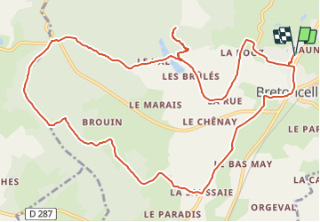
Tocht Stappen van 13,5 km beschikbaar op Normandië, Orne, Bretoncelles. Deze tocht wordt voorgesteld door ODDAD78.
Beschrijving
Quitter le parking en longeant La Donnette jusqu’à la D 918, tourner à droite et rejoindre le bourg, la place de l’église, direction Condé-sur-Huisne.
Prendre à droite le chemin d’Arrondeau. Franchir La Corbionne.
Au moulin, à gauche. Traverser la D 38, continuer tout droit sur la route jusqu’à « La Saussaie »
Tourner à droite vers La Martinière, La Pilottière, La Boisselière.
Au carrefour, prendre à gauche le chemin de la Butte du Noyer qui monte en forêt. Passer sous la ligne électrique et à un carrefour en Y, à gauche pour rejoindre le chemin qui délimite les communes de Dorceau et Bretoncelles.
A La Bouillerie, prendre le chemin de droite qui ramène à la D 38.
La descendre à droite sur 100 m environ et prendre à gauche un petit sentier (accessibilité par une barrière à pousser). A droite, passer sous la ligne électrique et obliquer légèrement à droite vers un petit chemin, humide parfois, descendant, montant et serpentant. 800 m plus loin, atteindre l’orée de la forêt de Saussaye et sortir en tirant la barrière.
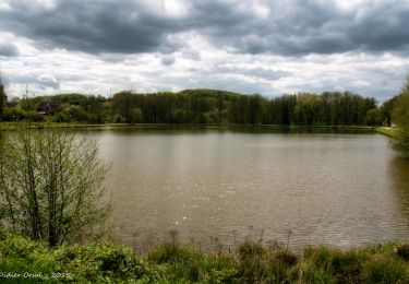
Dépasser Le Val, le chemin longe la digue d’un étang. (A cet endroit, un pupitre vous informe sur la motte féodale et vous indique le chemin à parcourir pour faire un aller-retour). Suivez Saussaie, puis La Rue.
A la Croix Guérin, continuer tout droit vers la Booz. Traversez le hameau ; rejoindre la D 620 puis retour au parking par le Pont de Crochet et la rue Henri Levier.
Plaatsbepaling
Opmerkingen
Wandeltochten in de omgeving
![Tocht Stappen La Madeleine-Bouvet - Les belles vues de Saint-Laumer et de la Madeleine Variante 10 Km - Photo](https://media.geolcdn.com/t/375/260/87362449-0ee3-40df-8df0-c17fd7220994.jpg&format=jpg&maxdim=2)
![Stappen Stappen](https://static1.geolcdn.com/sitytour/trail-icons/101.png)
Stappen
![](/images/other/stat-length.png)
![](https://static1.geolcdn.com/siteimages/upload/files/16400158638029165_repeat_loop_refresh_sync_direction_icon.png)
![Tocht Stappen La Madeleine-Bouvet - Les belles vues de Saint-Laumer et de la Madeleine 11 Km - Photo](https://media.geolcdn.com/t/375/260/3ee85883-b7ae-45a3-90c4-8bb6a4479600.jpg&format=jpg&maxdim=2)
![Stappen Stappen](https://static1.geolcdn.com/sitytour/trail-icons/101.png)
Stappen
![](/images/other/stat-length.png)
![](https://static1.geolcdn.com/siteimages/upload/files/16400158638029165_repeat_loop_refresh_sync_direction_icon.png)
![Tocht Stappen Bretoncelles - BRETONCELLES ET SES HAMEAUX - Photo](https://media.geolcdn.com/t/375/260/1ac05758-9066-478d-9efc-58a133a29698.jpg&format=jpg&maxdim=2)
![Stappen Stappen](https://static1.geolcdn.com/sitytour/trail-icons/101.png)
Stappen
![](/images/other/stat-length.png)
![](https://static1.geolcdn.com/siteimages/upload/files/16400158638029165_repeat_loop_refresh_sync_direction_icon.png)
![Tocht Stappen Moutiers-au-Perche - 2023-05-20_10h18m41_Moutiers-au-Perche Rando de Samedi - Photo](https://media.geolcdn.com/t/375/260/dd304cf5-1fa7-4625-9960-289d50411375.jpg&format=jpg&maxdim=2)
![Stappen Stappen](https://static1.geolcdn.com/sitytour/trail-icons/101.png)
Stappen
![](/images/other/stat-length.png)
![](https://static1.geolcdn.com/siteimages/upload/files/16400158638029165_repeat_loop_refresh_sync_direction_icon.png)
![Tocht Te voet Moutiers-au-Perche - Perche authentique - Photo](https://media.geolcdn.com/t/375/260/1c5fa599-8a3f-4902-99d5-149fc7bd1ba4.jpeg&format=jpg&maxdim=2)
![Te voet Te voet](https://static1.geolcdn.com/sitytour/trail-icons/100.png)
Te voet
![](/images/other/stat-length.png)
![](https://static1.geolcdn.com/siteimages/upload/files/16400158638029165_repeat_loop_refresh_sync_direction_icon.png)
![Tocht Stappen La Madeleine-Bouvet - Bretoncelles - La Madeleine-Bouvet 5,3 km - Photo](https://media.geolcdn.com/t/375/260/573e294c-51f9-41fe-8907-e8f30e9f4bad.jpg&format=jpg&maxdim=2)
![Stappen Stappen](https://static1.geolcdn.com/sitytour/trail-icons/101.png)
Stappen
![](/images/other/stat-length.png)
![](https://static1.geolcdn.com/siteimages/upload/files/16400158638029165_repeat_loop_refresh_sync_direction_icon.png)
![Tocht Stappen Bretoncelles - SityTrail - Les Douves du Grand Cumont Bretoncelles V2 15 Km - Photo](https://media.geolcdn.com/t/375/260/d3f7aac7-ac8c-46dc-96d3-852253cb1421.jpg&format=jpg&maxdim=2)
![Stappen Stappen](https://static1.geolcdn.com/sitytour/trail-icons/101.png)
Stappen
![](/images/other/stat-length.png)
![](https://static1.geolcdn.com/siteimages/upload/files/16400158638029165_repeat_loop_refresh_sync_direction_icon.png)
![Tocht Stappen Bretoncelles - SityTrail - Le Petit Houx du Parc - Bretoncelles 5,1 Km - Photo](https://media.geolcdn.com/t/375/260/7bdb7e04-5754-4fe7-8144-30a332f42ad5.jpg&format=jpg&maxdim=2)
![Stappen Stappen](https://static1.geolcdn.com/sitytour/trail-icons/101.png)
Stappen
![](/images/other/stat-length.png)
![](https://static1.geolcdn.com/siteimages/upload/files/16400158638029165_repeat_loop_refresh_sync_direction_icon.png)
![Tocht Stappen Bretoncelles - SityTrail - La boucle des Trois Moulins Bretoncelles 27,0 Km - Photo](https://media.geolcdn.com/t/375/260/5529bff9-ebf0-4b36-a1dd-763157d3177d.jpg&format=jpg&maxdim=2)
![Stappen Stappen](https://static1.geolcdn.com/sitytour/trail-icons/101.png)
Stappen
![](/images/other/stat-length.png)
![](https://static1.geolcdn.com/siteimages/upload/files/16400158638029165_repeat_loop_refresh_sync_direction_icon.png)