Tocht Stappen Empeaux - Empeaux circuit cross - Photo

Empeaux circuit cross

 pidjam
pidjam

Gebruiker

© OpenStreetMap contributors
Lengte
Lengte
9,7 km
Max. hoogte
Max. hoogte
318 m
Positief hoogteverschil
212 m
Km-Effort
Km-Effort  
12,5 km
Min. hoogte
Min. hoogte
167 m
Negatief hoogteverschil
215 m
Boucle
Boucle
Ja
Datum van aanmaak :
2016-10-22 00:00:00.0
Laatste wijziging :
2016-10-22 00:00:00.0

(0 Bericht)

Stappen
Stappen
2h40
Moeilijkheid : Gemakkelijk

Scan deze QR-code om de tocht te openen in de SityTrail-applicatie

Gratisgps-wandelapplicatie

Logo SityTrail SityTrail

IGN / Geografische instituten

SityTrail uit de App Store downloaden SityTrail uit Google Play downloaden

Logo SityTrail SityTrail World

De wereld gaat voor u open

SityTrail uit de App Store downloaden SityTrail uit Google Play downloaden SityTrail op Huawei AppGallery downloaden

Over ons

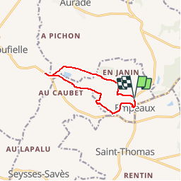
Tocht Stappen van 9,7 km beschikbaar op Occitanië, Haute-Garonne, Empeaux. Deze tocht wordt voorgesteld door pidjam.

Beschrijving

Balisé au tout début ce circuit reprend une partie de l'ancien "circuit des Arroques".Il passe près du superbe château d'Empeaux (clôturé).
Le passage près du circuit de cross est à trouver en contrebas.
Le moulin (non mis en valeur) de Larribaut est dans une propriété privée.
La balade est belle.(2015)

Hoogteprofiel

Plaatsbepaling

Land:
France
Regio :
Occitanië
Departement/Provincie :
Haute-Garonne
Gemeente :
Empeaux
Locatie:
Unknown
Vertrek:(Dec)
Vertrek:(UTM)
345457 ; 4821789 (31T) N.

Wandeltochten in de omgeving

Tocht Stappen Saiguède - Raide de Saiguède - Photo
Stappen
tracegps

Stappen

Moeilijk
(1)
Saiguède, Occitanië, Haute-Garonne, France
19 km | 23 km-effort
4h 0min
Ja
Tocht Stappen Sainte-Foy-de-Peyrolières - RANDO-Ste Foy Téléthon 2012 - Photo
Stappen
Polo-31

Stappen

Gemakkelijk
Sainte-Foy-de-Peyrolières, Occitanië, Haute-Garonne, France
8 km | 9,3 km-effort
2h 2min
Ja
Tocht Stappen Sainte-Foy-de-Peyrolières - Lac et bois autour de Sainte Foy de Peyrolières - Photo
Stappen
tracegps

Stappen

Gemakkelijk
Sainte-Foy-de-Peyrolières, Occitanië, Haute-Garonne, France
9 km | 11,2 km-effort
2h 30min
Ja
Tocht Stappen Sainte-Foy-de-Peyrolières - Ste Foy de Peyrolières 13 Avril 2020 - Photo
Stappen
daniel3157

Stappen

Gemakkelijk
Sainte-Foy-de-Peyrolières, Occitanië, Haute-Garonne, France
16,4 km | 21 km-effort
4h 58min
Ja
Tocht Lopen Saiguède - Raide de Saiguède - Photo
Lopen
tracegps

Lopen

Zeer moeilijk
Saiguède, Occitanië, Haute-Garonne, France
19 km | 23 km-effort
2h 0min
Ja
Tocht Stappen Sainte-Foy-de-Peyrolières - Randonnée Sainte Foy de Peyrolières  - Photo
Stappen
Fafou64

Stappen

Sainte-Foy-de-Peyrolières, Occitanië, Haute-Garonne, France
10,7 km | 12,9 km-effort
2h 39min
Ja
Tocht Stappen Saiguède - Saiguède belles vues - Photo
Stappen
pidjam

Stappen

Heel gemakkelijk
Saiguède, Occitanië, Haute-Garonne, France
8,3 km | 10,5 km-effort
2h 0min
Ja
Tocht Stappen Saint-Thomas - st thomas long - Photo
Stappen
pidjam

Stappen

Gemakkelijk
Saint-Thomas, Occitanië, Haute-Garonne, France
12,1 km | 15,8 km-effort
3h 22min
Ja
Tocht Mountainbike Sainte-Foy-de-Peyrolières - Le GR 86 de Sainte Foy de Peyrolières à Aurignac - Photo
Mountainbike
tracegps

Mountainbike

Zeer moeilijk
Sainte-Foy-de-Peyrolières, Occitanië, Haute-Garonne, France
74 km | 92 km-effort
7h 0min
Neen


Sluiten
Mijn abonnementen