![](/images/other/stat-length.png)
![Tocht Stappen Coupvray - Coupvray 19.5 km - Photo](https://media.geolcdn.com/t/1900/400/ext.pjpeg?maxdim=2&url=https%3A%2F%2Fstatic1.geolcdn.com%2Fsiteimages%2Fupload%2Ffiles%2F1553511878bg_sport_marche.png)
Coupvray 19.5 km
GOELERANDO2
Gebruiker
![Lengte](/images/other/stat-length.png)
Lengte
17,3 km
![Max. hoogte](https://static1.geolcdn.com/siteimages/upload/files/1508320355ic_sort_altitude_max_24dp.png)
Max. hoogte
85 m
![Positief hoogteverschil](https://static1.geolcdn.com/siteimages/upload/files/1508320355ic_sort_den_pos_24dp.png)
Positief hoogteverschil
163 m
![Km-Effort](/images/other/stat-length.png)
Km-Effort
19,5 km
![Min. hoogte](https://static1.geolcdn.com/siteimages/upload/files/1508320355ic_sort_altitude_min_24dp.png)
Min. hoogte
37 m
![Negatief hoogteverschil](https://static1.geolcdn.com/siteimages/upload/files/1508320355ic_sort_den_neg_24dp.png)
Negatief hoogteverschil
163 m
![Boucle](https://static1.geolcdn.com/siteimages/upload/files/16400158638029165_repeat_loop_refresh_sync_direction_icon.png)
Boucle
Ja
Datum van aanmaak :
2016-10-19 00:00:00.0
Laatste wijziging :
2016-10-19 00:00:00.0
![Stappen](https://static1.geolcdn.com/sitytour/trail-icons/101.png)
5h22
Moeilijkheid : Moeilijk
![Scan deze QR-code om de tocht te openen in de SityTrail-applicatie](https://capi.geolives.com/qq0zvz2zws4bq2lad0pu/sitytour/trails/645018/qr.png?size=200)
Gratisgps-wandelapplicatie
Over ons
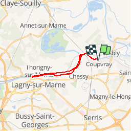
Tocht Stappen van 17,3 km beschikbaar op Île-de-France, Seine-et-Marne, Coupvray. Deze tocht wordt voorgesteld door GOELERANDO2.
Beschrijving
Parking rue de Lesches vers le musée Braille de Coupvray.
Départ au pied du pont sur le canal de Meaux.
Carte IGN 2414 ET
Long. 2°47.53,E
Lat. 48°53.73, N
A/R 54 km
Plaatsbepaling
Land:
France
Regio :
Île-de-France
Departement/Provincie :
Seine-et-Marne
Gemeente :
Coupvray
Locatie:
Unknown
Vertrek:(Dec)
Vertrek:(UTM)
484813 ; 5415754 (31U) N.
Opmerkingen
Wandeltochten in de omgeving
![Tocht Stappen Jablines - SM_JABLINES_7.4Km - Photo](https://media.geolcdn.com/t/375/260/c8961113-df44-42a9-8e26-efaf3b924948.jpg&format=jpg&maxdim=2)
![Stappen Stappen](https://static1.geolcdn.com/sitytour/trail-icons/101.png)
SM_JABLINES_7.4Km
Stappen
Medium
(8)
Jablines,
Île-de-France,
Seine-et-Marne,
France
![](/images/other/stat-length.png)
7,4 km | 8 km-effort
1h 49min
![](https://static1.geolcdn.com/siteimages/upload/files/16400158638029165_repeat_loop_refresh_sync_direction_icon.png)
Ja
![Tocht Stappen Coupvray - Boucle > 30 km Coupvray -Meaux - Photo](https://media.geolcdn.com/t/375/260/1a6eabe0-97f0-4d36-8738-577eed6cd854.jpg&format=jpg&maxdim=2)
![Stappen Stappen](https://static1.geolcdn.com/sitytour/trail-icons/101.png)
Boucle > 30 km Coupvray -Meaux
Stappen
Zeer moeilijk
(1)
Coupvray,
Île-de-France,
Seine-et-Marne,
France
![](/images/other/stat-length.png)
33 km | 37 km-effort
6h 28min
![](https://static1.geolcdn.com/siteimages/upload/files/16400158638029165_repeat_loop_refresh_sync_direction_icon.png)
Ja
![Tocht Stappen Dampmart - SM_DAMPMART-EST_8.1Km - Photo](https://media.geolcdn.com/t/375/260/6a085e8e-078f-48e9-8394-a9f3cb910770.jpg&format=jpg&maxdim=2)
![Stappen Stappen](https://static1.geolcdn.com/sitytour/trail-icons/101.png)
SM_DAMPMART-EST_8.1Km
Stappen
Medium
(3)
Dampmart,
Île-de-France,
Seine-et-Marne,
France
![](/images/other/stat-length.png)
8,1 km | 9,5 km-effort
2h 9min
![](https://static1.geolcdn.com/siteimages/upload/files/16400158638029165_repeat_loop_refresh_sync_direction_icon.png)
Ja
![Tocht Stappen Coupvray - SM_COUPVRAY_7.8Km - Photo](https://media.geolcdn.com/t/375/260/75105a38-25f4-4fb7-9ca5-8fbd77a01d44.jpg&format=jpg&maxdim=2)
![Stappen Stappen](https://static1.geolcdn.com/sitytour/trail-icons/101.png)
SM_COUPVRAY_7.8Km
Stappen
Medium
(1)
Coupvray,
Île-de-France,
Seine-et-Marne,
France
![](/images/other/stat-length.png)
7,8 km | 9,8 km-effort
2h 16min
![](https://static1.geolcdn.com/siteimages/upload/files/16400158638029165_repeat_loop_refresh_sync_direction_icon.png)
Ja
![Tocht Te voet Lesches - 16 km autour de la Sixtine de Seine et Marne - Photo](https://media.geolcdn.com/t/375/260/83a6e83b-e805-4672-a9c0-24c193746dd7.jpg&format=jpg&maxdim=2)
![Te voet Te voet](https://static1.geolcdn.com/sitytour/trail-icons/100.png)
16 km autour de la Sixtine de Seine et Marne
Te voet
Gemakkelijk
Lesches,
Île-de-France,
Seine-et-Marne,
France
![](/images/other/stat-length.png)
16,1 km | 18,2 km-effort
4h 8min
![](https://static1.geolcdn.com/siteimages/upload/files/16400158638029165_repeat_loop_refresh_sync_direction_icon.png)
Ja
![Tocht Stappen Coupvray - Boucle Coupvray - Meaux - Photo](https://media.geolcdn.com/t/375/260/99914e9a-87b8-42e9-a845-46cbd1aef9bb.jpg&format=jpg&maxdim=2)
![Stappen Stappen](https://static1.geolcdn.com/sitytour/trail-icons/101.png)
Boucle Coupvray - Meaux
Stappen
Zeer moeilijk
Coupvray,
Île-de-France,
Seine-et-Marne,
France
![](/images/other/stat-length.png)
30 km | 33 km-effort
6h 9min
![](https://static1.geolcdn.com/siteimages/upload/files/16400158638029165_repeat_loop_refresh_sync_direction_icon.png)
Ja
![Tocht Stappen Dampmart - ASAM Dampmart La Dhuys - Photo](https://media.geolcdn.com/t/375/260/ext.jpg?maxdim=2&url=https%3A%2F%2Fstatic1.geolcdn.com%2Fsiteimages%2Fupload%2Ffiles%2F1553511878bg_sport_marche.png)
![Stappen Stappen](https://static1.geolcdn.com/sitytour/trail-icons/101.png)
ASAM Dampmart La Dhuys
Stappen
Gemakkelijk
(1)
Dampmart,
Île-de-France,
Seine-et-Marne,
France
![](/images/other/stat-length.png)
4,5 km | 5,4 km-effort
1h 13min
![](https://static1.geolcdn.com/siteimages/upload/files/16400158638029165_repeat_loop_refresh_sync_direction_icon.png)
Ja
![Tocht Stappen Dampmart - Boucle 23 km Dampmart Annet sur Marne Base de Jabeline - Photo](https://media.geolcdn.com/t/375/260/b5b3d0bd-39cc-46d3-b0d4-bbe25a7dde4e.jpg&format=jpg&maxdim=2)
![Stappen Stappen](https://static1.geolcdn.com/sitytour/trail-icons/101.png)
Boucle 23 km Dampmart Annet sur Marne Base de Jabeline
Stappen
Medium
Dampmart,
Île-de-France,
Seine-et-Marne,
France
![](/images/other/stat-length.png)
23 km | 27 km-effort
5h 11min
![](https://static1.geolcdn.com/siteimages/upload/files/16400158638029165_repeat_loop_refresh_sync_direction_icon.png)
Ja
![Tocht Stappen Dampmart - Boucle autour de Dampmart - Photo](https://media.geolcdn.com/t/375/260/5feb6ded-9010-40ac-8591-20a068c0f9dc.jpg&format=jpg&maxdim=2)
![Stappen Stappen](https://static1.geolcdn.com/sitytour/trail-icons/101.png)
Boucle autour de Dampmart
Stappen
Medium
Dampmart,
Île-de-France,
Seine-et-Marne,
France
![](/images/other/stat-length.png)
22 km | 25 km-effort
6h 24min
![](https://static1.geolcdn.com/siteimages/upload/files/16400158638029165_repeat_loop_refresh_sync_direction_icon.png)
Ja