![](/images/other/stat-length.png)
![Tocht Stappen Neaufles-Saint-Martin - Neaufles Saint Martin, les étangs, La lévrière etc, 11,6 km - Photo](https://media.geolcdn.com/t/1900/400/ext.pjpeg?maxdim=2&url=https%3A%2F%2Fstatic1.geolcdn.com%2Fsiteimages%2Fupload%2Ffiles%2F1553511878bg_sport_marche.png)
Neaufles Saint Martin, les étangs, La lévrière etc, 11,6 km
Marie-Claire-mcp
Gebruiker
![Lengte](/images/other/stat-length.png)
Lengte
11,6 km
![Max. hoogte](https://static1.geolcdn.com/siteimages/upload/files/1508320355ic_sort_altitude_max_24dp.png)
Max. hoogte
90 m
![Positief hoogteverschil](https://static1.geolcdn.com/siteimages/upload/files/1508320355ic_sort_den_pos_24dp.png)
Positief hoogteverschil
133 m
![Km-Effort](/images/other/stat-length.png)
Km-Effort
13,4 km
![Min. hoogte](https://static1.geolcdn.com/siteimages/upload/files/1508320355ic_sort_altitude_min_24dp.png)
Min. hoogte
40 m
![Negatief hoogteverschil](https://static1.geolcdn.com/siteimages/upload/files/1508320355ic_sort_den_neg_24dp.png)
Negatief hoogteverschil
133 m
![Boucle](https://static1.geolcdn.com/siteimages/upload/files/16400158638029165_repeat_loop_refresh_sync_direction_icon.png)
Boucle
Ja
Datum van aanmaak :
2016-10-01 00:00:00.0
Laatste wijziging :
2016-10-01 00:00:00.0
![Stappen](https://static1.geolcdn.com/sitytour/trail-icons/101.png)
2h58
Moeilijkheid : Medium
![Scan deze QR-code om de tocht te openen in de SityTrail-applicatie](https://capi.geolives.com/qq0zvz2zws4bq2lad0pu/sitytour/trails/639113/qr.png?size=200)
Gratisgps-wandelapplicatie
Over ons
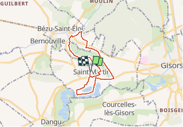
Tocht Stappen van 11,6 km beschikbaar op Normandië, Eure, Neaufles-Saint-Martin. Deze tocht wordt voorgesteld door Marie-Claire-mcp.
Beschrijving
Neaufles Saint Martin départ Mairie puis direction les Etangs puis Levrière, citée du vitrex, rue des bouillons, Bézu, Neaufle
Plaatsbepaling
Land:
France
Regio :
Normandië
Departement/Provincie :
Eure
Gemeente :
Neaufles-Saint-Martin
Locatie:
Unknown
Vertrek:(Dec)
Vertrek:(UTM)
407099 ; 5458893 (31U) N.
Opmerkingen
Wandeltochten in de omgeving
![Tocht Stappen Boury-en-Vexin - Boury en Vexin - Hérouval - Photo](https://media.geolcdn.com/t/375/260/ext.jpg?maxdim=2&url=https%3A%2F%2Fservices.sitytrail.com%2FGeolivesWS%2FDownloadMedia.ashx%3FTrailID%3D158258%26Media%3D70479d1b-26bd-4332-9afe-06d6c1ec1e96.jpg)
![Stappen Stappen](https://static1.geolcdn.com/sitytour/trail-icons/101.png)
Boury en Vexin - Hérouval
Stappen
Gemakkelijk
(3)
Boury-en-Vexin,
Hauts-de-France,
Oise,
France
![](/images/other/stat-length.png)
10,9 km | 12,9 km-effort
2h 49min
![](https://static1.geolcdn.com/siteimages/upload/files/16400158638029165_repeat_loop_refresh_sync_direction_icon.png)
Ja
![Tocht Stappen Vaudancourt - Vaudancourt - Breuil et Boury - Photo](https://media.geolcdn.com/t/375/260/ext.jpg?maxdim=2&url=https%3A%2F%2Fservices.sitytrail.com%2FGeolivesWS%2FDownloadMedia.ashx%3FTrailID%3D157619%26Media%3D1550d1cf-9f43-43fc-88a1-2fb31ebab517.jpg)
![Stappen Stappen](https://static1.geolcdn.com/sitytour/trail-icons/101.png)
Vaudancourt - Breuil et Boury
Stappen
Gemakkelijk
(1)
Vaudancourt,
Hauts-de-France,
Oise,
France
![](/images/other/stat-length.png)
11,8 km | 14,3 km-effort
3h 5min
![](https://static1.geolcdn.com/siteimages/upload/files/16400158638029165_repeat_loop_refresh_sync_direction_icon.png)
Ja
![Tocht Stappen Bézu-Saint-Éloi - Bézu Saint Eloi - Départ du parking route de Gisors (place St Eloi), puis Neaufles St martin - Photo](https://media.geolcdn.com/t/375/260/ext.jpg?maxdim=2&url=https%3A%2F%2Fstatic1.geolcdn.com%2Fsiteimages%2Fupload%2Ffiles%2F1553511878bg_sport_marche.png)
![Stappen Stappen](https://static1.geolcdn.com/sitytour/trail-icons/101.png)
Bézu Saint Eloi - Départ du parking route de Gisors (place St Eloi), puis Nea...
Stappen
Medium
(1)
Bézu-Saint-Éloi,
Normandië,
Eure,
France
![](/images/other/stat-length.png)
10,3 km | 12 km-effort
2h 43min
![](https://static1.geolcdn.com/siteimages/upload/files/16400158638029165_repeat_loop_refresh_sync_direction_icon.png)
Ja
![Tocht Stappen Noyers - Noyers - Vesly et ND du chêne - Photo](https://media.geolcdn.com/t/375/260/ext.jpg?maxdim=2&url=https%3A%2F%2Fstatic1.geolcdn.com%2Fsiteimages%2Fupload%2Ffiles%2F1553511878bg_sport_marche.png)
![Stappen Stappen](https://static1.geolcdn.com/sitytour/trail-icons/101.png)
Noyers - Vesly et ND du chêne
Stappen
Medium
(1)
Noyers,
Normandië,
Eure,
France
![](/images/other/stat-length.png)
13,6 km | 16,5 km-effort
2h 30min
![](https://static1.geolcdn.com/siteimages/upload/files/16400158638029165_repeat_loop_refresh_sync_direction_icon.png)
Ja
![Tocht Noords wandelen Bézu-Saint-Éloi - Marche Nordique 89 Bezu Saint Eloi - Photo](https://media.geolcdn.com/t/375/260/ext.jpg?maxdim=2&url=https%3A%2F%2Fstatic1.geolcdn.com%2Fsiteimages%2Fupload%2Ffiles%2F1545311037marcheuse_200dpi.jpg)
![Noords wandelen Noords wandelen](https://static1.geolcdn.com/sitytour/trail-icons/102.png)
Marche Nordique 89 Bezu Saint Eloi
Noords wandelen
Gemakkelijk
(1)
Bézu-Saint-Éloi,
Normandië,
Eure,
France
![](/images/other/stat-length.png)
8,6 km | 10 km-effort
1h 30min
![](https://static1.geolcdn.com/siteimages/upload/files/16400158638029165_repeat_loop_refresh_sync_direction_icon.png)
Ja
![Tocht Noords wandelen Boury-en-Vexin - Marche Nordique 75 Boury en Vexin - Photo](https://media.geolcdn.com/t/375/260/ext.jpg?maxdim=2&url=https%3A%2F%2Fstatic1.geolcdn.com%2Fsiteimages%2Fupload%2Ffiles%2F1545311037marcheuse_200dpi.jpg)
![Noords wandelen Noords wandelen](https://static1.geolcdn.com/sitytour/trail-icons/102.png)
Marche Nordique 75 Boury en Vexin
Noords wandelen
Gemakkelijk
(1)
Boury-en-Vexin,
Hauts-de-France,
Oise,
France
![](/images/other/stat-length.png)
10,3 km | 12,6 km-effort
1h 30min
![](https://static1.geolcdn.com/siteimages/upload/files/16400158638029165_repeat_loop_refresh_sync_direction_icon.png)
Ja
![Tocht Noords wandelen Courcelles-lès-Gisors - Marche Nordique 71 Courcelles les Gisors - Photo](https://media.geolcdn.com/t/375/260/ext.jpg?maxdim=2&url=https%3A%2F%2Fstatic1.geolcdn.com%2Fsiteimages%2Fupload%2Ffiles%2F1545311037marcheuse_200dpi.jpg)
![Noords wandelen Noords wandelen](https://static1.geolcdn.com/sitytour/trail-icons/102.png)
Marche Nordique 71 Courcelles les Gisors
Noords wandelen
Heel gemakkelijk
(2)
Courcelles-lès-Gisors,
Hauts-de-France,
Oise,
France
![](/images/other/stat-length.png)
9,2 km | 10,9 km-effort
1h 26min
![](https://static1.geolcdn.com/siteimages/upload/files/16400158638029165_repeat_loop_refresh_sync_direction_icon.png)
Ja
![Tocht Stappen Gisors - gisors champêtre et historique - Photo](https://media.geolcdn.com/t/375/260/578633a8-4c05-457b-921d-405112e7b824.jpg&format=jpg&maxdim=2)
![Stappen Stappen](https://static1.geolcdn.com/sitytour/trail-icons/101.png)
gisors champêtre et historique
Stappen
Moeilijk
Gisors,
Normandië,
Eure,
France
![](/images/other/stat-length.png)
12,1 km | 13,6 km-effort
2h 13min
![](https://static1.geolcdn.com/siteimages/upload/files/16400158638029165_repeat_loop_refresh_sync_direction_icon.png)
Ja
![Tocht Stappen Vesly - Vesly côte de Guerny Gisancourt et le chêne, ferme de Nainville - Photo](https://media.geolcdn.com/t/375/260/672dd815-f964-4745-bb5d-c86df75a6f84.jpg&format=jpg&maxdim=2)
![Stappen Stappen](https://static1.geolcdn.com/sitytour/trail-icons/101.png)
Vesly côte de Guerny Gisancourt et le chêne, ferme de Nainville
Stappen
Moeilijk
Vesly,
Normandië,
Eure,
France
![](/images/other/stat-length.png)
10,1 km | 12,5 km-effort
2h 25min
![](https://static1.geolcdn.com/siteimages/upload/files/16400158638029165_repeat_loop_refresh_sync_direction_icon.png)
Ja