![](/images/other/stat-length.png)
![Tocht Motor Boves - longueau circuit 1 eric - Photo](https://media.geolcdn.com/t/1900/400/ext.pjpeg?maxdim=2&url=https%3A%2F%2Fservices.sitytrail.com%2FGeolivesWS%2FDownloadMedia.ashx%3FTrailID%3D636243%26Media%3D48646eca-3e2c-4615-a6d1-72c3b6f6b849.jpg)
longueau circuit 1 eric
eric80330
Gebruiker
![Lengte](/images/other/stat-length.png)
Lengte
51 km
![Max. hoogte](https://static1.geolcdn.com/siteimages/upload/files/1508320355ic_sort_altitude_max_24dp.png)
Max. hoogte
131 m
![Positief hoogteverschil](https://static1.geolcdn.com/siteimages/upload/files/1508320355ic_sort_den_pos_24dp.png)
Positief hoogteverschil
753 m
![Km-Effort](/images/other/stat-length.png)
Km-Effort
61 km
![Min. hoogte](https://static1.geolcdn.com/siteimages/upload/files/1508320355ic_sort_altitude_min_24dp.png)
Min. hoogte
25 m
![Negatief hoogteverschil](https://static1.geolcdn.com/siteimages/upload/files/1508320355ic_sort_den_neg_24dp.png)
Negatief hoogteverschil
752 m
![Boucle](https://static1.geolcdn.com/siteimages/upload/files/16400158638029165_repeat_loop_refresh_sync_direction_icon.png)
Boucle
Ja
Datum van aanmaak :
2017-05-10 00:00:00.0
Laatste wijziging :
2017-05-10 00:00:00.0
![Motor](https://static1.geolcdn.com/sitytour/trail-icons/400.png)
3h00
Moeilijkheid : Medium
![Scan deze QR-code om de tocht te openen in de SityTrail-applicatie](https://capi.geolives.com/qq0zvz2zws4bq2lad0pu/sitytour/trails/636243/qr.png?size=200)
Gratisgps-wandelapplicatie
Over ons
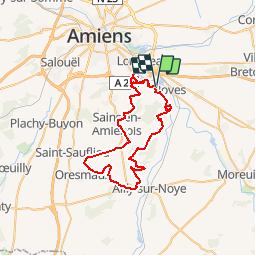
Tocht Motor van 51 km beschikbaar op Hauts-de-France, Somme, Boves. Deze tocht wordt voorgesteld door eric80330.
Beschrijving
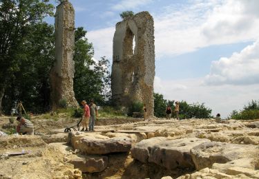
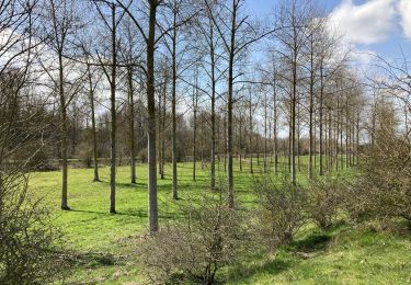
Ce parcours traverse le bois de Fau Timon,contourne le bois Magneux ;rando dans les plaine
tourne entre cottenchy ,fouenceant boves , retour cagny
Plaatsbepaling
Land:
France
Regio :
Hauts-de-France
Departement/Provincie :
Somme
Gemeente :
Boves
Locatie:
Unknown
Vertrek:(Dec)
Vertrek:(UTM)
454976 ; 5521964 (31U) N.
Opmerkingen
Wandeltochten in de omgeving
![Tocht Stappen Boves - 20190606-Boves - Photo](https://media.geolcdn.com/t/375/260/ext.jpg?maxdim=2&url=https%3A%2F%2Fstatic1.geolcdn.com%2Fsiteimages%2Fupload%2Ffiles%2F1553511878bg_sport_marche.png)
![Stappen Stappen](https://static1.geolcdn.com/sitytour/trail-icons/101.png)
20190606-Boves
Stappen
Medium
(1)
Boves,
Hauts-de-France,
Somme,
France
![](/images/other/stat-length.png)
24 km | 28 km-effort
6h 31min
![](https://static1.geolcdn.com/siteimages/upload/files/16400158638029165_repeat_loop_refresh_sync_direction_icon.png)
Ja
![Tocht Te voet Boves - Sainte-Ulphe - Photo](https://media.geolcdn.com/t/375/260/f794ff92-058a-48a4-aa54-dbc0fc355bd0.jpeg&format=jpg&maxdim=2)
![Te voet Te voet](https://static1.geolcdn.com/sitytour/trail-icons/100.png)
Sainte-Ulphe
Te voet
Gemakkelijk
Boves,
Hauts-de-France,
Somme,
France
![](/images/other/stat-length.png)
12,3 km | 14,2 km-effort
3h 13min
![](https://static1.geolcdn.com/siteimages/upload/files/16400158638029165_repeat_loop_refresh_sync_direction_icon.png)
Ja
![Tocht Stappen Fouencamps - Autour des trains 2 - Photo](https://media.geolcdn.com/t/375/260/ext.jpg?maxdim=2&url=https%3A%2F%2Fstatic1.geolcdn.com%2Fsiteimages%2Fupload%2Ffiles%2F1553511878bg_sport_marche.png)
![Stappen Stappen](https://static1.geolcdn.com/sitytour/trail-icons/101.png)
Autour des trains 2
Stappen
Medium
(2)
Fouencamps,
Hauts-de-France,
Somme,
France
![](/images/other/stat-length.png)
9,2 km | 10,7 km-effort
Onbekend
![](https://static1.geolcdn.com/siteimages/upload/files/16400158638029165_repeat_loop_refresh_sync_direction_icon.png)
Ja
![Tocht Stappen Sains-en-Amiénois - Circuit du Cambos - Sains-en-Amienois - Photo](https://media.geolcdn.com/t/375/260/ext.jpg?maxdim=2&url=https%3A%2F%2Fservices.sitytrail.com%2FGeolivesWS%2FDownloadMedia.ashx%3FTrailID%3D112076%26Media%3D9691_5.jpg)
![Stappen Stappen](https://static1.geolcdn.com/sitytour/trail-icons/101.png)
Circuit du Cambos - Sains-en-Amienois
Stappen
Zeer moeilijk
Sains-en-Amiénois,
Hauts-de-France,
Somme,
France
![](/images/other/stat-length.png)
16,8 km | 20 km-effort
4h 10min
![](https://static1.geolcdn.com/siteimages/upload/files/16400158638029165_repeat_loop_refresh_sync_direction_icon.png)
Ja
![Tocht Stappen Sains-en-Amiénois - Circuit de Rumigny - Sains-en-Amienois - Photo](https://media.geolcdn.com/t/375/260/ext.jpg?maxdim=2&url=https%3A%2F%2Fservices.sitytrail.com%2FGeolivesWS%2FDownloadMedia.ashx%3FTrailID%3D105809%26Media%3D9731_3.jpg)
![Stappen Stappen](https://static1.geolcdn.com/sitytour/trail-icons/101.png)
Circuit de Rumigny - Sains-en-Amienois
Stappen
Medium
Sains-en-Amiénois,
Hauts-de-France,
Somme,
France
![](/images/other/stat-length.png)
10,9 km | 12,7 km-effort
2h 15min
![](https://static1.geolcdn.com/siteimages/upload/files/16400158638029165_repeat_loop_refresh_sync_direction_icon.png)
Ja
![Tocht Mountainbike Longueau - Plaine et bois autour de Grattepanche - Longueau - Photo](https://media.geolcdn.com/t/375/260/ext.jpg?maxdim=2&url=https%3A%2F%2Fservices.sitytrail.com%2FGeolivesWS%2FDownloadMedia.ashx%3FTrailID%3D103832%26Media%3D6613_4.jpg)
![Mountainbike Mountainbike](https://static1.geolcdn.com/sitytour/trail-icons/202.png)
Plaine et bois autour de Grattepanche - Longueau
Mountainbike
Medium
Longueau,
Hauts-de-France,
Somme,
France
![](/images/other/stat-length.png)
44 km | 53 km-effort
2h 30min
![](https://static1.geolcdn.com/siteimages/upload/files/16400158638029165_repeat_loop_refresh_sync_direction_icon.png)
Neen
![Tocht Stappen Boves - BOVES - Photo](https://media.geolcdn.com/t/375/260/edcb816a-f065-4fb7-896e-e8e09b20486f.jpg&format=jpg&maxdim=2)
![Stappen Stappen](https://static1.geolcdn.com/sitytour/trail-icons/101.png)
![Tocht Stappen Camon - CAMON - Photo](https://media.geolcdn.com/t/375/260/1bf8ed16-1e55-413a-8d01-1b9bd69c3085.jpg&format=jpg&maxdim=2)
![Stappen Stappen](https://static1.geolcdn.com/sitytour/trail-icons/101.png)
![Tocht Stappen Camon - bords somme Camon - Photo](https://media.geolcdn.com/t/375/260/ext.jpg?maxdim=2&url=https%3A%2F%2Fservices.sitytrail.com%2FGeolivesWS%2FDownloadMedia.ashx%3FTrailID%3D146571%26Media%3D20120813145905.jpeg)
![Stappen Stappen](https://static1.geolcdn.com/sitytour/trail-icons/101.png)
bords somme Camon
Stappen
Heel gemakkelijk
Camon,
Hauts-de-France,
Somme,
France
![](/images/other/stat-length.png)
6,6 km | 7 km-effort
1h 35min
![](https://static1.geolcdn.com/siteimages/upload/files/16400158638029165_repeat_loop_refresh_sync_direction_icon.png)
Ja