Tocht Stappen Soulangis - Soulangis - Photo
 jlrayon
jlrayon

Gebruiker

© OpenStreetMap contributors
Lengte
Lengte
12,8 km
Max. hoogte
Max. hoogte
186 m
Positief hoogteverschil
81 m
Km-Effort
Km-Effort  
13,9 km
Min. hoogte
Min. hoogte
148 m
Negatief hoogteverschil
81 m
Boucle
Boucle
Ja
Datum van aanmaak :
2016-09-23 00:00:00.0
Laatste wijziging :
2016-09-23 00:00:00.0

(0 Bericht)

Stappen
Stappen
3h45
Moeilijkheid : Onbekend

Scan deze QR-code om de tocht te openen in de SityTrail-applicatie

Gratisgps-wandelapplicatie

Logo SityTrail SityTrail

IGN / Geografische instituten

SityTrail uit de App Store downloaden SityTrail uit Google Play downloaden

Logo SityTrail SityTrail World

De wereld gaat voor u open

SityTrail uit de App Store downloaden SityTrail uit Google Play downloaden SityTrail op Huawei AppGallery downloaden

Over ons

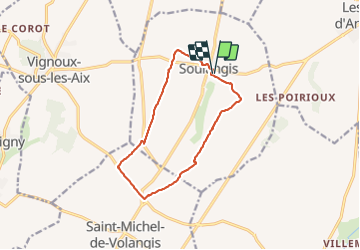
Tocht Stappen van 12,8 km beschikbaar op Centre-Val de Loire, Cher, Soulangis. Deze tocht wordt voorgesteld door jlrayon.

Beschrijving

Soulangis

Hoogteprofiel

Plaatsbepaling

Land:
France
Regio :
Centre-Val de Loire
Departement/Provincie :
Cher
Gemeente :
Soulangis
Locatie:
Unknown
Vertrek:(Dec)
Vertrek:(UTM)
463582 ; 5225885 (31T) N.

Wandeltochten in de omgeving

Tocht Andere activiteiten Menetou-Salon - gr31 - Photo
Andere activiteiten
stef18

Andere activiteiten

Heel gemakkelijk
Menetou-Salon, Centre-Val de Loire, Cher, France
9,4 km | 10,8 km-effort
57min
Neen
Tocht Mountainbike Les Aix-d'Angillon - Menetou - Sancerroise - 1ère édition Juillet 2010 - Photo
Mountainbike
tracegps

Mountainbike

Moeilijk
Les Aix-d'Angillon, Centre-Val de Loire, Cher, France
80 km | 100 km-effort
6h 30min
Ja
Tocht Stappen Soulangis - Soulangis - Photo
Stappen
jlrayon

Stappen

Gemakkelijk
Soulangis, Centre-Val de Loire, Cher, France
11,3 km | 12,3 km-effort
2h 27min
Ja
Tocht Fiets Les Aix-d'Angillon - Menetou Sancerroise 50km - Photo
Fiets
mokmok18

Fiets

Medium
Les Aix-d'Angillon, Centre-Val de Loire, Cher, France
50 km | 60 km-effort
3h 25min
Ja
Tocht Fiets Les Aix-d'Angillon - Menetou sancerroise - Photo
Fiets
mokmok18

Fiets

Zeer moeilijk
Les Aix-d'Angillon, Centre-Val de Loire, Cher, France
90 km | 115 km-effort
6h 40min
Ja
Tocht Mountainbike Les Aix-d'Angillon - Menetou sancerroise 70km - Photo
Mountainbike
mokmok18

Mountainbike

Moeilijk
Les Aix-d'Angillon, Centre-Val de Loire, Cher, France
71 km | 87 km-effort
5h 36min
Ja
Tocht Mountainbike Les Aix-d'Angillon - Coteaux de Morogues 2011 - Les Aix d'Angillon - Photo
Mountainbike
tracegps

Mountainbike

Moeilijk
Les Aix-d'Angillon, Centre-Val de Loire, Cher, France
40 km | 51 km-effort
3h 0min
Ja
Tocht Stappen Les Aix-d'Angillon - Coteaux de Morogues 2011 - Les Aix d'Angillon - Photo
Stappen
tracegps

Stappen

Moeilijk
Les Aix-d'Angillon, Centre-Val de Loire, Cher, France
40 km | 51 km-effort
8h 0min
Ja
Tocht Mountainbike Soulangis - soulangis 40km 550D+ - Photo
Mountainbike
gregvtt95

Mountainbike

Heel gemakkelijk
Soulangis, Centre-Val de Loire, Cher, France
39 km | 46 km-effort
2h 33min
Ja


Sluiten
Mijn abonnementen