![](/images/other/stat-length.png)
![Tocht Mountainbike Bussang - VTT de Bussang (8) - Photo](https://media.geolcdn.com/t/1900/400/ext.pjpeg?maxdim=2&url=https%3A%2F%2Fstatic1.geolcdn.com%2Fsiteimages%2Fupload%2Ffiles%2F1524743154velo.jpg)
VTT de Bussang (8)
pascalou73
Gebruiker GUIDE
![Lengte](/images/other/stat-length.png)
Lengte
25 km
![Max. hoogte](https://static1.geolcdn.com/siteimages/upload/files/1508320355ic_sort_altitude_max_24dp.png)
Max. hoogte
1014 m
![Positief hoogteverschil](https://static1.geolcdn.com/siteimages/upload/files/1508320355ic_sort_den_pos_24dp.png)
Positief hoogteverschil
697 m
![Km-Effort](/images/other/stat-length.png)
Km-Effort
34 km
![Min. hoogte](https://static1.geolcdn.com/siteimages/upload/files/1508320355ic_sort_altitude_min_24dp.png)
Min. hoogte
600 m
![Negatief hoogteverschil](https://static1.geolcdn.com/siteimages/upload/files/1508320355ic_sort_den_neg_24dp.png)
Negatief hoogteverschil
700 m
![Boucle](https://static1.geolcdn.com/siteimages/upload/files/16400158638029165_repeat_loop_refresh_sync_direction_icon.png)
Boucle
Neen
Datum van aanmaak :
2016-09-05 00:00:00.0
Laatste wijziging :
2016-09-05 00:00:00.0
![Mountainbike](https://static1.geolcdn.com/sitytour/trail-icons/202.png)
--
Moeilijkheid : Moeilijk
![Scan deze QR-code om de tocht te openen in de SityTrail-applicatie](https://capi.geolives.com/qq0zvz2zws4bq2lad0pu/sitytour/trails/626671/qr.png?size=200)
Gratisgps-wandelapplicatie
Over ons
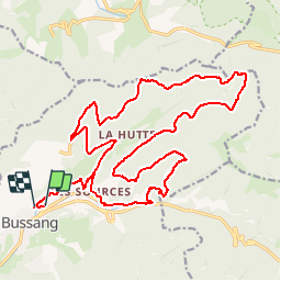
Tocht Mountainbike van 25 km beschikbaar op Grand Est, Vogezen, Bussang. Deze tocht wordt voorgesteld door pascalou73.
Beschrijving
Un VTT dans la région des hautes Vosges . Dans une belle forêt sur des sentiers de toute beautés au départ du village de Bussang.
Plaatsbepaling
Land:
France
Regio :
Grand Est
Departement/Provincie :
Vogezen
Gemeente :
Bussang
Locatie:
Unknown
Vertrek:(Dec)
Vertrek:(UTM)
340074 ; 5306210 (32T) N.
Opmerkingen
Wandeltochten in de omgeving
![Tocht Stappen Bussang - Col de Bussang - Rouge Gazon - Séchenat - Photo](https://media.geolcdn.com/t/375/260/ext.jpg?maxdim=2&url=https%3A%2F%2Fservices.sitytrail.com%2FGeolivesWS%2FDownloadMedia.ashx%3FTrailID%3D450013%26Media%3Dfix__20150715145430.jpg)
![Stappen Stappen](https://static1.geolcdn.com/sitytour/trail-icons/101.png)
Col de Bussang - Rouge Gazon - Séchenat
Stappen
Moeilijk
(1)
Bussang,
Grand Est,
Vogezen,
France
![](/images/other/stat-length.png)
15 km | 24 km-effort
6h 0min
![](https://static1.geolcdn.com/siteimages/upload/files/16400158638029165_repeat_loop_refresh_sync_direction_icon.png)
Neen
![Tocht Sneeuwschoenen Bussang - Circuit de raquette de Bussang - Photo](https://media.geolcdn.com/t/375/260/ext.jpg?maxdim=2&url=https%3A%2F%2Fservices.sitytrail.com%2FGeolivesWS%2FDownloadMedia.ashx%3FTrailID%3D111638%26Media%3D7873_6.jpg)
![Sneeuwschoenen Sneeuwschoenen](https://static1.geolcdn.com/sitytour/trail-icons/504.png)
Circuit de raquette de Bussang
Sneeuwschoenen
Moeilijk
(1)
Bussang,
Grand Est,
Vogezen,
France
![](/images/other/stat-length.png)
7,7 km | 11,2 km-effort
3h 0min
![](https://static1.geolcdn.com/siteimages/upload/files/16400158638029165_repeat_loop_refresh_sync_direction_icon.png)
Ja
![Tocht Stappen Storckensohn - lac des perches marchettes - Photo](https://media.geolcdn.com/t/375/260/ba8e93c4-c66a-48b1-88b8-cca79cc3effc.jpg&format=jpg&maxdim=2)
![Stappen Stappen](https://static1.geolcdn.com/sitytour/trail-icons/101.png)
lac des perches marchettes
Stappen
Medium
(1)
Storckensohn,
Grand Est,
Haut-Rhin,
France
![](/images/other/stat-length.png)
11,9 km | 20 km-effort
4h 8min
![](https://static1.geolcdn.com/siteimages/upload/files/16400158638029165_repeat_loop_refresh_sync_direction_icon.png)
Ja
![Tocht Stappen Fellering - Felsach _chapelle ST Nicolas_frenz - Photo](https://media.geolcdn.com/t/375/260/ext.jpg?maxdim=2&url=https%3A%2F%2Fstatic1.geolcdn.com%2Fsiteimages%2Fupload%2Ffiles%2F1553511878bg_sport_marche.png)
![Stappen Stappen](https://static1.geolcdn.com/sitytour/trail-icons/101.png)
Felsach _chapelle ST Nicolas_frenz
Stappen
Moeilijk
(3)
Fellering,
Grand Est,
Haut-Rhin,
France
![](/images/other/stat-length.png)
9,6 km | 16,5 km-effort
3h 45min
![](https://static1.geolcdn.com/siteimages/upload/files/16400158638029165_repeat_loop_refresh_sync_direction_icon.png)
Ja
![Mountainbike Mountainbike](https://static1.geolcdn.com/sitytour/trail-icons/202.png)
SityTrail - 3248441 - documentxix745004916x3256137
Mountainbike
Medium
Saint-Maurice-sur-Moselle,
Grand Est,
Vogezen,
France
![](/images/other/stat-length.png)
21 km | 30 km-effort
2h 3min
![](https://static1.geolcdn.com/siteimages/upload/files/16400158638029165_repeat_loop_refresh_sync_direction_icon.png)
Ja
![Mountainbike Mountainbike](https://static1.geolcdn.com/sitytour/trail-icons/202.png)
activity_9407679223
Mountainbike
Medium
Bussang,
Grand Est,
Vogezen,
France
![](/images/other/stat-length.png)
21 km | 30 km-effort
2h 2min
![](https://static1.geolcdn.com/siteimages/upload/files/16400158638029165_repeat_loop_refresh_sync_direction_icon.png)
Ja
![Tocht Stappen Storckensohn - 2022-07-16 Marche Auberge Gazon Vert Chapelle des Ves - Photo](https://media.geolcdn.com/t/375/260/7aac2105-88e6-44f1-a6d0-d41240d9f4c5.jpg&format=jpg&maxdim=2)
![Stappen Stappen](https://static1.geolcdn.com/sitytour/trail-icons/101.png)
2022-07-16 Marche Auberge Gazon Vert Chapelle des Ves
Stappen
Zeer moeilijk
Storckensohn,
Grand Est,
Haut-Rhin,
France
![](/images/other/stat-length.png)
21 km | 37 km-effort
6h 11min
![](https://static1.geolcdn.com/siteimages/upload/files/16400158638029165_repeat_loop_refresh_sync_direction_icon.png)
Neen
![Tocht Stappen Ventron - 2022-02-19 Marche Ventron Tête des Champs - Photo](https://media.geolcdn.com/t/375/260/06aadd17-f4b2-4026-a19b-5cf0f11fcd92.jpg&format=jpg&maxdim=2)
![Stappen Stappen](https://static1.geolcdn.com/sitytour/trail-icons/101.png)
2022-02-19 Marche Ventron Tête des Champs
Stappen
Zeer moeilijk
Ventron,
Grand Est,
Vogezen,
France
![](/images/other/stat-length.png)
22 km | 34 km-effort
5h 52min
![](https://static1.geolcdn.com/siteimages/upload/files/16400158638029165_repeat_loop_refresh_sync_direction_icon.png)
Ja
![Tocht Te voet Ventron - Circuit de la Croix de l’Hermite par Forgoutte - Photo](https://media.geolcdn.com/t/375/260/d9c2017f-89af-4e26-9799-43d15f74a50f.jpeg&format=jpg&maxdim=2)
![Te voet Te voet](https://static1.geolcdn.com/sitytour/trail-icons/100.png)
Circuit de la Croix de l’Hermite par Forgoutte
Te voet
Gemakkelijk
Ventron,
Grand Est,
Vogezen,
France
![](/images/other/stat-length.png)
4,3 km | 6,6 km-effort
1h 29min
![](https://static1.geolcdn.com/siteimages/upload/files/16400158638029165_repeat_loop_refresh_sync_direction_icon.png)
Neen