![](/images/other/stat-length.png)
![Tocht Stappen Etsaut - Boucle 5 jours vallée de l'aspe - Photo](https://media.geolcdn.com/t/1900/400/ext.pjpeg?maxdim=2&url=https%3A%2F%2Fstatic1.geolcdn.com%2Fsiteimages%2Fupload%2Ffiles%2F1553511878bg_sport_marche.png)
Boucle 5 jours vallée de l'aspe
Bzh56
Gebruiker
![Lengte](/images/other/stat-length.png)
Lengte
89 km
![Max. hoogte](https://static1.geolcdn.com/siteimages/upload/files/1508320355ic_sort_altitude_max_24dp.png)
Max. hoogte
2183 m
![Positief hoogteverschil](https://static1.geolcdn.com/siteimages/upload/files/1508320355ic_sort_den_pos_24dp.png)
Positief hoogteverschil
4977 m
![Km-Effort](/images/other/stat-length.png)
Km-Effort
155 km
![Min. hoogte](https://static1.geolcdn.com/siteimages/upload/files/1508320355ic_sort_altitude_min_24dp.png)
Min. hoogte
590 m
![Negatief hoogteverschil](https://static1.geolcdn.com/siteimages/upload/files/1508320355ic_sort_den_neg_24dp.png)
Negatief hoogteverschil
4975 m
![Boucle](https://static1.geolcdn.com/siteimages/upload/files/16400158638029165_repeat_loop_refresh_sync_direction_icon.png)
Boucle
Ja
Datum van aanmaak :
2016-08-24 00:00:00.0
Laatste wijziging :
2016-08-24 00:00:00.0
![Stappen](https://static1.geolcdn.com/sitytour/trail-icons/101.png)
26h29
Moeilijkheid : Medium
![Scan deze QR-code om de tocht te openen in de SityTrail-applicatie](https://capi.geolives.com/qq0zvz2zws4bq2lad0pu/sitytour/trails/620045/qr.png?size=200)
Gratisgps-wandelapplicatie
Over ons
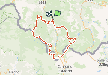
Tocht Stappen van 89 km beschikbaar op Nieuw-Aquitanië, Pyrénées-Atlantiques, Etsaut. Deze tocht wordt voorgesteld door Bzh56.
Beschrijving
Superbe randonnée en boucle de 5 jours au départ d'Etsaut.
Durée 27h30 sans les arrêts,89 km, Dénivelé 4200m
Nuits au gite du Lauzart (Lescun), Refuge d'Arlet, Auberge Ayga (col du somport) et refuge d'Ayous.
Plaatsbepaling
Land:
France
Regio :
Nieuw-Aquitanië
Departement/Provincie :
Pyrénées-Atlantiques
Gemeente :
Etsaut
Locatie:
Unknown
Vertrek:(Dec)
Vertrek:(UTM)
698347 ; 4754018 (30T) N.
Opmerkingen
Wandeltochten in de omgeving
![Tocht Sneeuwschoenen Borce - Refuge et lac d’Arlet - Photo](https://media.geolcdn.com/t/375/260/a5cc868f-a627-4b9d-939f-bef0d8443aec.jpg&format=jpg&maxdim=2)
![Sneeuwschoenen Sneeuwschoenen](https://static1.geolcdn.com/sitytour/trail-icons/504.png)
Refuge et lac d’Arlet
Sneeuwschoenen
Medium
(1)
Borce,
Nieuw-Aquitanië,
Pyrénées-Atlantiques,
France
![](/images/other/stat-length.png)
16,9 km | 30 km-effort
6h 49min
![](https://static1.geolcdn.com/siteimages/upload/files/16400158638029165_repeat_loop_refresh_sync_direction_icon.png)
Ja
![Tocht Stappen Etsaut - CHEMIN DE LA MATURE - Photo](https://media.geolcdn.com/t/375/260/ext.jpg?maxdim=2&url=https%3A%2F%2Fservices.sitytrail.com%2FGeolivesWS%2FDownloadMedia.ashx%3FTrailID%3D330343%26Media%3Dfix__20140727111121.jpg)
![Stappen Stappen](https://static1.geolcdn.com/sitytour/trail-icons/101.png)
CHEMIN DE LA MATURE
Stappen
Medium
(2)
Etsaut,
Nieuw-Aquitanië,
Pyrénées-Atlantiques,
France
![](/images/other/stat-length.png)
8,8 km | 18,6 km-effort
3h 25min
![](https://static1.geolcdn.com/siteimages/upload/files/16400158638029165_repeat_loop_refresh_sync_direction_icon.png)
Ja
![Tocht Stappen Etsaut - Chemin de la Mâture en vallée d'Aspe - Photo](https://media.geolcdn.com/t/375/260/ext.jpg?maxdim=2&url=https%3A%2F%2Fservices.sitytrail.com%2FGeolivesWS%2FDownloadMedia.ashx%3FTrailID%3D109346%26Media%3D3629_1.jpg)
![Stappen Stappen](https://static1.geolcdn.com/sitytour/trail-icons/101.png)
Chemin de la Mâture en vallée d'Aspe
Stappen
Moeilijk
(1)
Etsaut,
Nieuw-Aquitanië,
Pyrénées-Atlantiques,
France
![](/images/other/stat-length.png)
7,5 km | 16,8 km-effort
4h 0min
![](https://static1.geolcdn.com/siteimages/upload/files/16400158638029165_repeat_loop_refresh_sync_direction_icon.png)
Ja
![Tocht Te voet Cette-Eygun - Granges de Cette asp56 - Photo](https://media.geolcdn.com/t/375/260/45ec37bb-ebfa-4fac-a648-b2e50bb11731.jpeg&format=jpg&maxdim=2)
![Te voet Te voet](https://static1.geolcdn.com/sitytour/trail-icons/100.png)
Granges de Cette asp56
Te voet
Gemakkelijk
Cette-Eygun,
Nieuw-Aquitanië,
Pyrénées-Atlantiques,
France
![](/images/other/stat-length.png)
5,4 km | 10,2 km-effort
2h 18min
![](https://static1.geolcdn.com/siteimages/upload/files/16400158638029165_repeat_loop_refresh_sync_direction_icon.png)
Ja
![Tocht Te voet Cette-Eygun - Cabane de Lhèze asp116 - Photo](https://media.geolcdn.com/t/375/260/45ec37bb-ebfa-4fac-a648-b2e50bb11731.jpeg&format=jpg&maxdim=2)
![Te voet Te voet](https://static1.geolcdn.com/sitytour/trail-icons/100.png)
Cabane de Lhèze asp116
Te voet
Gemakkelijk
Cette-Eygun,
Nieuw-Aquitanië,
Pyrénées-Atlantiques,
France
![](/images/other/stat-length.png)
3,6 km | 9,7 km-effort
2h 11min
![](https://static1.geolcdn.com/siteimages/upload/files/16400158638029165_repeat_loop_refresh_sync_direction_icon.png)
Neen
![Tocht Te voet Cette-Eygun - Cabanes de Narbèze asp117 - Photo](https://media.geolcdn.com/t/375/260/45ec37bb-ebfa-4fac-a648-b2e50bb11731.jpeg&format=jpg&maxdim=2)
![Te voet Te voet](https://static1.geolcdn.com/sitytour/trail-icons/100.png)
Cabanes de Narbèze asp117
Te voet
Gemakkelijk
Cette-Eygun,
Nieuw-Aquitanië,
Pyrénées-Atlantiques,
France
![](/images/other/stat-length.png)
6,5 km | 16,6 km-effort
3h 45min
![](https://static1.geolcdn.com/siteimages/upload/files/16400158638029165_repeat_loop_refresh_sync_direction_icon.png)
Neen
![Tocht Te voet Urdos - Tour Urdos - Bérat asp66 - Photo](https://media.geolcdn.com/t/375/260/6386a7ee-b394-4eb6-89b9-f6e5520be03f.jpeg&format=jpg&maxdim=2)
![Te voet Te voet](https://static1.geolcdn.com/sitytour/trail-icons/100.png)
Tour Urdos - Bérat asp66
Te voet
Gemakkelijk
Urdos,
Nieuw-Aquitanië,
Pyrénées-Atlantiques,
France
![](/images/other/stat-length.png)
4,4 km | 6,8 km-effort
1h 32min
![](https://static1.geolcdn.com/siteimages/upload/files/16400158638029165_repeat_loop_refresh_sync_direction_icon.png)
Ja
![Tocht Te voet Cette-Eygun - Tour de Lasies asp115 - Photo](https://media.geolcdn.com/t/375/260/c7bf7b32-3f7c-4bff-b706-8b021e3df474.jpeg&format=jpg&maxdim=2)
![Te voet Te voet](https://static1.geolcdn.com/sitytour/trail-icons/100.png)
Tour de Lasies asp115
Te voet
Gemakkelijk
Cette-Eygun,
Nieuw-Aquitanië,
Pyrénées-Atlantiques,
France
![](/images/other/stat-length.png)
4,3 km | 8,7 km-effort
1h 59min
![](https://static1.geolcdn.com/siteimages/upload/files/16400158638029165_repeat_loop_refresh_sync_direction_icon.png)
Neen
![Tocht Te voet Etsaut - Chemin de Beloute asp118 - Photo](https://media.geolcdn.com/t/375/260/c8c5e68c-6418-4f8e-ac8d-ca44ee2eda0b.jpeg&format=jpg&maxdim=2)
![Te voet Te voet](https://static1.geolcdn.com/sitytour/trail-icons/100.png)
Chemin de Beloute asp118
Te voet
Gemakkelijk
Etsaut,
Nieuw-Aquitanië,
Pyrénées-Atlantiques,
France
![](/images/other/stat-length.png)
3,1 km | 8,3 km-effort
1h 53min
![](https://static1.geolcdn.com/siteimages/upload/files/16400158638029165_repeat_loop_refresh_sync_direction_icon.png)
Neen