![](/images/other/stat-length.png)
![Tocht Mountainbike Sarlat-la-Canéda - Sarlat / Aillac / Carsac - Photo](https://media.geolcdn.com/t/1900/400/ext.pjpeg?maxdim=2&url=https%3A%2F%2Fstatic1.geolcdn.com%2Fsiteimages%2Fupload%2Ffiles%2F1524743154velo.jpg)
Sarlat / Aillac / Carsac
Bora431
Gebruiker
![Lengte](/images/other/stat-length.png)
Lengte
23 km
![Max. hoogte](https://static1.geolcdn.com/siteimages/upload/files/1508320355ic_sort_altitude_max_24dp.png)
Max. hoogte
208 m
![Positief hoogteverschil](https://static1.geolcdn.com/siteimages/upload/files/1508320355ic_sort_den_pos_24dp.png)
Positief hoogteverschil
425 m
![Km-Effort](/images/other/stat-length.png)
Km-Effort
29 km
![Min. hoogte](https://static1.geolcdn.com/siteimages/upload/files/1508320355ic_sort_altitude_min_24dp.png)
Min. hoogte
73 m
![Negatief hoogteverschil](https://static1.geolcdn.com/siteimages/upload/files/1508320355ic_sort_den_neg_24dp.png)
Negatief hoogteverschil
424 m
![Boucle](https://static1.geolcdn.com/siteimages/upload/files/16400158638029165_repeat_loop_refresh_sync_direction_icon.png)
Boucle
Ja
Datum van aanmaak :
2016-08-20 00:00:00.0
Laatste wijziging :
2016-08-20 00:00:00.0
![Mountainbike](https://static1.geolcdn.com/sitytour/trail-icons/202.png)
1h30
Moeilijkheid : Medium
![Scan deze QR-code om de tocht te openen in de SityTrail-applicatie](https://capi.geolives.com/qq0zvz2zws4bq2lad0pu/sitytour/trails/617654/qr.png?size=200)
Gratisgps-wandelapplicatie
Over ons
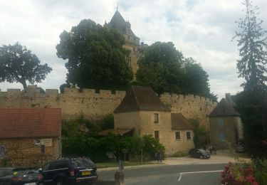
Tocht Mountainbike van 23 km beschikbaar op Nieuw-Aquitanië, Dordogne, Sarlat-la-Canéda. Deze tocht wordt voorgesteld door Bora431.
Beschrijving
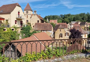
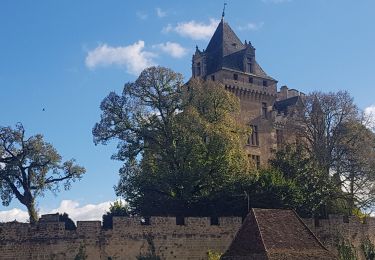
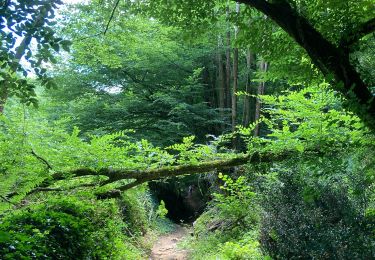
Très jolie ballade empruntant la piste cyclable puis bifurquant jusqu'au Bouyssou, Et ascension d'un Pech pour redescendre sur Aillac. Ensuite on suit la Dordogne jusqu'à Carsac et retour par la Piste cyclable. Location de vélos au parking.
Plaatsbepaling
Land:
France
Regio :
Nieuw-Aquitanië
Departement/Provincie :
Dordogne
Gemeente :
Sarlat-la-Canéda
Locatie:
Unknown
Vertrek:(Dec)
Vertrek:(UTM)
360314 ; 4970533 (31T) N.
Opmerkingen
Wandeltochten in de omgeving
![Tocht Stappen Sarlat-la-Canéda - La Sarladaise - Photo](https://media.geolcdn.com/t/375/260/2933f563-5f6e-403e-b8c7-e2f4704e7fbf.jpg&format=jpg&maxdim=2)
![Stappen Stappen](https://static1.geolcdn.com/sitytour/trail-icons/101.png)
La Sarladaise
Stappen
Moeilijk
(1)
Sarlat-la-Canéda,
Nieuw-Aquitanië,
Dordogne,
France
![](/images/other/stat-length.png)
13,7 km | 18,9 km-effort
3h 26min
![](https://static1.geolcdn.com/siteimages/upload/files/16400158638029165_repeat_loop_refresh_sync_direction_icon.png)
Ja
![Tocht sport Vitrac - 2022-09-11_00h25m31_SityTrail - 3339419 - vitrac-boucle-de-marobert - Photo](https://media.geolcdn.com/t/375/260/ext.jpg?maxdim=2&url=https%3A%2F%2Fsecurestorage.geolives.com%2Fsitytour%2Ftrail-bg%2Fdefault.jpg)
2022-09-11_00h25m31_SityTrail - 3339419 - vitrac-boucle-de-marobert
sport
Heel gemakkelijk
(1)
Vitrac,
Nieuw-Aquitanië,
Dordogne,
France
![](/images/other/stat-length.png)
7,2 km | 9,9 km-effort
Onbekend
![](https://static1.geolcdn.com/siteimages/upload/files/16400158638029165_repeat_loop_refresh_sync_direction_icon.png)
Ja
![Tocht Te voet Sarlat-la-Canéda - Chemin Harrison Barker (Vallée Dordogne) - Photo](https://media.geolcdn.com/t/375/260/27825bbe-4822-437a-a93e-b68df4103e60.jpeg&format=jpg&maxdim=2)
![Te voet Te voet](https://static1.geolcdn.com/sitytour/trail-icons/100.png)
Chemin Harrison Barker (Vallée Dordogne)
Te voet
Zeer moeilijk
Sarlat-la-Canéda,
Nieuw-Aquitanië,
Dordogne,
France
![](/images/other/stat-length.png)
56 km | 75 km-effort
16h 57min
![](https://static1.geolcdn.com/siteimages/upload/files/16400158638029165_repeat_loop_refresh_sync_direction_icon.png)
Neen
![Tocht Stappen Vitrac - Vitrac, Périgord, journée un - Photo](https://media.geolcdn.com/t/375/260/c7dfc74d-487d-45c4-8651-176e0274128f.jpg&format=jpg&maxdim=2)
![Stappen Stappen](https://static1.geolcdn.com/sitytour/trail-icons/101.png)
Vitrac, Périgord, journée un
Stappen
Gemakkelijk
Vitrac,
Nieuw-Aquitanië,
Dordogne,
France
![](/images/other/stat-length.png)
8,9 km | 11,6 km-effort
2h 20min
![](https://static1.geolcdn.com/siteimages/upload/files/16400158638029165_repeat_loop_refresh_sync_direction_icon.png)
Ja
![Tocht Hybride fiets Sarlat-la-Canéda - Sarlat - Cazoules (Dordogne) - Photo](https://media.geolcdn.com/t/375/260/f39591b6-cc2c-4edd-a916-67a42d0b39f4.jpg&format=jpg&maxdim=2)
![Hybride fiets Hybride fiets](https://static1.geolcdn.com/sitytour/trail-icons/203.png)
Sarlat - Cazoules (Dordogne)
Hybride fiets
Medium
Sarlat-la-Canéda,
Nieuw-Aquitanië,
Dordogne,
France
![](/images/other/stat-length.png)
49 km | 57 km-effort
3h 56min
![](https://static1.geolcdn.com/siteimages/upload/files/16400158638029165_repeat_loop_refresh_sync_direction_icon.png)
Ja
![Tocht Stappen Saint-Vincent-le-Paluel - Boucle du Paluel - Photo](https://media.geolcdn.com/t/375/260/ext.jpg?maxdim=2&url=https%3A%2F%2Fstatic1.geolcdn.com%2Fsiteimages%2Fupload%2Ffiles%2F1553511878bg_sport_marche.png)
![Stappen Stappen](https://static1.geolcdn.com/sitytour/trail-icons/101.png)
Boucle du Paluel
Stappen
Moeilijk
(1)
Saint-Vincent-le-Paluel,
Nieuw-Aquitanië,
Dordogne,
France
![](/images/other/stat-length.png)
10,7 km | 13,6 km-effort
3h 5min
![](https://static1.geolcdn.com/siteimages/upload/files/16400158638029165_repeat_loop_refresh_sync_direction_icon.png)
Ja
![Stappen Stappen](https://static1.geolcdn.com/sitytour/trail-icons/101.png)
Randonnée du 05/03/2023 à 14:47
Stappen
Zeer moeilijk
Vitrac,
Nieuw-Aquitanië,
Dordogne,
France
![](/images/other/stat-length.png)
13,2 km | 19,7 km-effort
4h 28min
![](https://static1.geolcdn.com/siteimages/upload/files/16400158638029165_repeat_loop_refresh_sync_direction_icon.png)
Ja
![Tocht Stappen Saint-Vincent-le-Paluel - Rando Dordogne jour 1 - Photo](https://media.geolcdn.com/t/375/260/cfec1289-9526-4294-b5f6-f93e54f813ee.jpg&format=jpg&maxdim=2)
![Stappen Stappen](https://static1.geolcdn.com/sitytour/trail-icons/101.png)
Rando Dordogne jour 1
Stappen
Medium
Saint-Vincent-le-Paluel,
Nieuw-Aquitanië,
Dordogne,
France
![](/images/other/stat-length.png)
17,2 km | 22 km-effort
5h 17min
![](https://static1.geolcdn.com/siteimages/upload/files/16400158638029165_repeat_loop_refresh_sync_direction_icon.png)
Neen
![Tocht Stappen Vitrac - Boucle de Marobert - Photo](https://media.geolcdn.com/t/375/260/0fd77c73-70f5-4d8a-a8c2-68179f69fb88.jpg&format=jpg&maxdim=2)
![Stappen Stappen](https://static1.geolcdn.com/sitytour/trail-icons/101.png)
Boucle de Marobert
Stappen
Medium
Vitrac,
Nieuw-Aquitanië,
Dordogne,
France
![](/images/other/stat-length.png)
7,8 km | 10,6 km-effort
2h 33min
![](https://static1.geolcdn.com/siteimages/upload/files/16400158638029165_repeat_loop_refresh_sync_direction_icon.png)
Ja