![](/images/other/stat-length.png)
![Tocht Stappen Le Valtin - Col de la Schlucht-Sentier des Roches - Photo](https://media.geolcdn.com/t/1900/400/ext.pjpeg?maxdim=2&url=https%3A%2F%2Fstatic1.geolcdn.com%2Fsiteimages%2Fupload%2Ffiles%2F1553511878bg_sport_marche.png)
Col de la Schlucht-Sentier des Roches
LaurentGILG
Gebruiker
![Lengte](/images/other/stat-length.png)
![Max. hoogte](https://static1.geolcdn.com/siteimages/upload/files/1508320355ic_sort_altitude_max_24dp.png)
![Positief hoogteverschil](https://static1.geolcdn.com/siteimages/upload/files/1508320355ic_sort_den_pos_24dp.png)
![Km-Effort](/images/other/stat-length.png)
![Min. hoogte](https://static1.geolcdn.com/siteimages/upload/files/1508320355ic_sort_altitude_min_24dp.png)
![Negatief hoogteverschil](https://static1.geolcdn.com/siteimages/upload/files/1508320355ic_sort_den_neg_24dp.png)
![Boucle](https://static1.geolcdn.com/siteimages/upload/files/16400158638029165_repeat_loop_refresh_sync_direction_icon.png)
![Stappen](https://static1.geolcdn.com/sitytour/trail-icons/101.png)
7h02
Moeilijkheid : Zeer moeilijk
![Scan deze QR-code om de tocht te openen in de SityTrail-applicatie](https://capi.geolives.com/qq0zvz2zws4bq2lad0pu/sitytour/trails/588748/qr.png?size=200)
Gratisgps-wandelapplicatie
Over ons
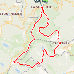
Tocht Stappen van 21 km beschikbaar op Grand Est, Vogezen, Le Valtin. Deze tocht wordt voorgesteld door LaurentGILG.
Beschrijving
Depart Col de la Schlucht.
Prendre sentier des Roches,rectangle bleu.
Puis direction Gacsney.
Puis Lac de Schiessrothried,tjrs rectangle bleu.
Puis lac du Fischboedle,rectangle rouge.
Puis Kerbholz, bleu.
Puis Kastelbergwasen,rectangle bleu.
Puis Ferschmuss,rectangle bleu.
Puis GR5,rectanle rouge et blanc,direction Le Hohneck.
Puis les 3 fours,rectangle rouge.
Puis col de la Schlucht,rectangle rouge.
POI's
Plaatsbepaling
Opmerkingen
Wandeltochten in de omgeving
![Tocht Stappen Le Valtin - Les Rochers des Hirschsteine - Lac Vert - Photo](https://media.geolcdn.com/t/375/260/4177d9e5-d8bc-4dac-ac45-c42f01ca30d3.jpg&format=jpg&maxdim=2)
![Stappen Stappen](https://static1.geolcdn.com/sitytour/trail-icons/101.png)
Stappen
![](/images/other/stat-length.png)
![](https://static1.geolcdn.com/siteimages/upload/files/16400158638029165_repeat_loop_refresh_sync_direction_icon.png)
![Tocht Stappen Le Valtin - Col de la Schlucht - Photo](https://media.geolcdn.com/t/375/260/5b598871-c43c-4378-92fe-f06bddb4af29.jpg&format=jpg&maxdim=2)
![Stappen Stappen](https://static1.geolcdn.com/sitytour/trail-icons/101.png)
Stappen
![](/images/other/stat-length.png)
![](https://static1.geolcdn.com/siteimages/upload/files/16400158638029165_repeat_loop_refresh_sync_direction_icon.png)
![Tocht Stappen Le Valtin - Le Sentier des Roches - Photo](https://media.geolcdn.com/t/375/260/f2737479-0e9e-43ec-9b66-c9706dc8ef91.jpg&format=jpg&maxdim=2)
![Stappen Stappen](https://static1.geolcdn.com/sitytour/trail-icons/101.png)
Stappen
![](/images/other/stat-length.png)
![](https://static1.geolcdn.com/siteimages/upload/files/16400158638029165_repeat_loop_refresh_sync_direction_icon.png)
![Tocht Stappen Stosswihr - Tour du belvedere avec le passage sur les crêtes - Photo](https://media.geolcdn.com/t/375/260/5b3c85c1-2643-45e9-9769-80e100e05dda.jpg&format=jpg&maxdim=2)
![Stappen Stappen](https://static1.geolcdn.com/sitytour/trail-icons/101.png)
Stappen
![](/images/other/stat-length.png)
![](https://static1.geolcdn.com/siteimages/upload/files/16400158638029165_repeat_loop_refresh_sync_direction_icon.png)
![Tocht Andere activiteiten Soultzeren - Totom 4 lacs - Photo](https://media.geolcdn.com/t/375/260/ext.jpg?maxdim=2&url=https%3A%2F%2Fservices.sitytrail.com%2FGeolivesWS%2FDownloadMedia.ashx%3FTrailID%3D789048%26Media%3D20170713134427.jpg)
![Andere activiteiten Andere activiteiten](https://static1.geolcdn.com/sitytour/trail-icons/900.png)
Andere activiteiten
![](/images/other/stat-length.png)
![](https://static1.geolcdn.com/siteimages/upload/files/16400158638029165_repeat_loop_refresh_sync_direction_icon.png)
![Stappen Stappen](https://static1.geolcdn.com/sitytour/trail-icons/101.png)
Stappen
![](/images/other/stat-length.png)
![](https://static1.geolcdn.com/siteimages/upload/files/16400158638029165_repeat_loop_refresh_sync_direction_icon.png)
![Tocht Stappen Le Valtin - Les Hirschsteine - Photo](https://media.geolcdn.com/t/375/260/ext.jpg?maxdim=2&url=https%3A%2F%2Fservices.sitytrail.com%2FGeolivesWS%2FDownloadMedia.ashx%3FTrailID%3D311037%26Media%3Dfix__20140608114301.jpg)
![Stappen Stappen](https://static1.geolcdn.com/sitytour/trail-icons/101.png)
Stappen
![](/images/other/stat-length.png)
![](https://static1.geolcdn.com/siteimages/upload/files/16400158638029165_repeat_loop_refresh_sync_direction_icon.png)
![Tocht Stappen La Bresse - Du Hohneck au Kastelberg par les Spietzkoepfe et le Sentier des Névées - Photo](https://media.geolcdn.com/t/375/260/ext.jpg?maxdim=2&url=https%3A%2F%2Fservices.sitytrail.com%2FGeolivesWS%2FDownloadMedia.ashx%3FTrailID%3D110319%26Media%3D5746_5.jpg)
![Stappen Stappen](https://static1.geolcdn.com/sitytour/trail-icons/101.png)
Stappen
![](/images/other/stat-length.png)
![](https://static1.geolcdn.com/siteimages/upload/files/16400158638029165_repeat_loop_refresh_sync_direction_icon.png)
![Tocht Stappen Soultzeren - Tanet-Gazon du faing par lac vert et retour sommet du Tanet - Photo](https://media.geolcdn.com/t/375/260/ed68be74-246f-440b-833e-a0b4a96a4c20.jpg&format=jpg&maxdim=2)
![Stappen Stappen](https://static1.geolcdn.com/sitytour/trail-icons/101.png)
Stappen
![](/images/other/stat-length.png)
![](https://static1.geolcdn.com/siteimages/upload/files/16400158638029165_repeat_loop_refresh_sync_direction_icon.png)