![](/images/other/stat-length.png)
![Tocht Stappen Simiane-la-Rotonde - Valsaintes: Le saut du moine - Photo](https://media.geolcdn.com/t/1900/400/ext.pjpeg?maxdim=2&url=https%3A%2F%2Fstatic1.geolcdn.com%2Fsiteimages%2Fupload%2Ffiles%2F1553511878bg_sport_marche.png)
Valsaintes: Le saut du moine
lviallet
Gebruiker
![Lengte](/images/other/stat-length.png)
![Max. hoogte](https://static1.geolcdn.com/siteimages/upload/files/1508320355ic_sort_altitude_max_24dp.png)
![Positief hoogteverschil](https://static1.geolcdn.com/siteimages/upload/files/1508320355ic_sort_den_pos_24dp.png)
![Km-Effort](/images/other/stat-length.png)
![Min. hoogte](https://static1.geolcdn.com/siteimages/upload/files/1508320355ic_sort_altitude_min_24dp.png)
![Negatief hoogteverschil](https://static1.geolcdn.com/siteimages/upload/files/1508320355ic_sort_den_neg_24dp.png)
![Boucle](https://static1.geolcdn.com/siteimages/upload/files/16400158638029165_repeat_loop_refresh_sync_direction_icon.png)
![Stappen](https://static1.geolcdn.com/sitytour/trail-icons/101.png)
2h57
Moeilijkheid : Gemakkelijk
![Scan deze QR-code om de tocht te openen in de SityTrail-applicatie](https://capi.geolives.com/qq0zvz2zws4bq2lad0pu/sitytour/trails/587385/qr.png?size=200)
Gratisgps-wandelapplicatie
Over ons
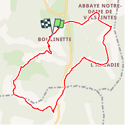
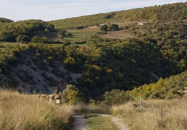
Tocht Stappen van 10,2 km beschikbaar op Provence-Alpes-Côte d'Azur, Alpes-de-Haute-Provence, Simiane-la-Rotonde. Deze tocht wordt voorgesteld door lviallet.
Beschrijving
Fait le 21/06/2016
Ballade tranquille et assez sympa.
Départ à 3Kms au nord
d'Oppedette.
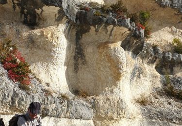
Passage à gué délicat au saut du moine après une période pluvieuse.
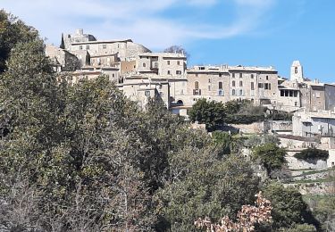
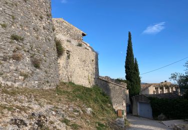
Abbaye de Valsaintes (Nommé maintenant Labadié)
L'abbaye fut transféré en 1668 au hameau de Boulinette et fermeture en l'an 1790.
Plaatsbepaling
Opmerkingen
Wandeltochten in de omgeving
![Tocht Stappen Oppedette - Gorges d'Oppedette(06-04-2015) - Photo](https://media.geolcdn.com/t/375/260/ext.jpg?maxdim=2&url=https%3A%2F%2Fservices.sitytrail.com%2FGeolivesWS%2FDownloadMedia.ashx%3FTrailID%3D404746%26Media%3Dfix__20150406152511.jpg)
![Stappen Stappen](https://static1.geolcdn.com/sitytour/trail-icons/101.png)
Stappen
![](/images/other/stat-length.png)
![](https://static1.geolcdn.com/siteimages/upload/files/16400158638029165_repeat_loop_refresh_sync_direction_icon.png)
![Tocht Stappen Oppedette - 2024-02-02 Oppedette Valsaintes Saut du moine - Photo](https://media.geolcdn.com/t/375/260/d37a3973-9a90-4474-879d-da972103a322.jpg&format=jpg&maxdim=2)
![Stappen Stappen](https://static1.geolcdn.com/sitytour/trail-icons/101.png)
Stappen
![](/images/other/stat-length.png)
![](https://static1.geolcdn.com/siteimages/upload/files/16400158638029165_repeat_loop_refresh_sync_direction_icon.png)
![Tocht Stappen Oppedette - LES Gorges d' oppedette - Photo](https://media.geolcdn.com/t/375/260/5856b46b-d295-4e7b-afe7-6b74836a07f2.jpg&format=jpg&maxdim=2)
![Stappen Stappen](https://static1.geolcdn.com/sitytour/trail-icons/101.png)
Stappen
![](/images/other/stat-length.png)
![](https://static1.geolcdn.com/siteimages/upload/files/16400158638029165_repeat_loop_refresh_sync_direction_icon.png)
![Tocht Stappen Simiane-la-Rotonde - 1Le Saut du Moine, parking pour les non marcheurs - Photo](https://media.geolcdn.com/t/375/260/7c4697a8-9110-4ec8-8589-e12efb361806.jpg&format=jpg&maxdim=2)
![Stappen Stappen](https://static1.geolcdn.com/sitytour/trail-icons/101.png)
Stappen
![](/images/other/stat-length.png)
![](https://static1.geolcdn.com/siteimages/upload/files/16400158638029165_repeat_loop_refresh_sync_direction_icon.png)
![Tocht Stappen Simiane-la-Rotonde - simiane - Photo](https://media.geolcdn.com/t/375/260/9b244400-871b-4623-b0a4-f5da5f8e3b49.jpg&format=jpg&maxdim=2)
![Stappen Stappen](https://static1.geolcdn.com/sitytour/trail-icons/101.png)
Stappen
![](/images/other/stat-length.png)
![](https://static1.geolcdn.com/siteimages/upload/files/16400158638029165_repeat_loop_refresh_sync_direction_icon.png)
![Tocht Stappen Gignac - RUSTREL Le Colorado provencal n - Photo](https://media.geolcdn.com/t/375/260/7afd17ae-ab89-4f75-88d4-c09ea3af773c.jpg&format=jpg&maxdim=2)
![Stappen Stappen](https://static1.geolcdn.com/sitytour/trail-icons/101.png)
Stappen
![](/images/other/stat-length.png)
![](https://static1.geolcdn.com/siteimages/upload/files/16400158638029165_repeat_loop_refresh_sync_direction_icon.png)
![Tocht Stappen Simiane-la-Rotonde - Simiane la Rotonde - Photo](https://media.geolcdn.com/t/375/260/dae667b8-3b14-4f9f-a2cd-cc4cb59c6ab1.jpg&format=jpg&maxdim=2)
![Stappen Stappen](https://static1.geolcdn.com/sitytour/trail-icons/101.png)
Stappen
![](/images/other/stat-length.png)
![](https://static1.geolcdn.com/siteimages/upload/files/16400158638029165_repeat_loop_refresh_sync_direction_icon.png)
![Tocht Stappen Vachères - Vachères 04 - Photo](https://media.geolcdn.com/t/375/260/1bace0c8-9770-455c-9be0-779a0a19465d.jpg&format=jpg&maxdim=2)
![Stappen Stappen](https://static1.geolcdn.com/sitytour/trail-icons/101.png)
Stappen
![](/images/other/stat-length.png)
![](https://static1.geolcdn.com/siteimages/upload/files/16400158638029165_repeat_loop_refresh_sync_direction_icon.png)
![Tocht Stappen Oppedette - PR- Gorges d'Oppedette - Photo](https://media.geolcdn.com/t/375/260/ext.jpg?maxdim=2&url=https%3A%2F%2Fstatic1.geolcdn.com%2Fsiteimages%2Fupload%2Ffiles%2F1553511878bg_sport_marche.png)
![Stappen Stappen](https://static1.geolcdn.com/sitytour/trail-icons/101.png)
Stappen
![](/images/other/stat-length.png)
![](https://static1.geolcdn.com/siteimages/upload/files/16400158638029165_repeat_loop_refresh_sync_direction_icon.png)