![](/images/other/stat-length.png)
![Tocht Fiets Bergheim - Slow Up Alsace - Photo](https://media.geolcdn.com/t/1900/400/ext.pjpeg?maxdim=2&url=https%3A%2F%2Fstatic1.geolcdn.com%2Fsiteimages%2Fupload%2Ffiles%2F1524743154velo.jpg)
Slow Up Alsace
Derrendinger
Gebruiker
![Lengte](/images/other/stat-length.png)
Lengte
33 km
![Max. hoogte](https://static1.geolcdn.com/siteimages/upload/files/1508320355ic_sort_altitude_max_24dp.png)
Max. hoogte
251 m
![Positief hoogteverschil](https://static1.geolcdn.com/siteimages/upload/files/1508320355ic_sort_den_pos_24dp.png)
Positief hoogteverschil
236 m
![Km-Effort](/images/other/stat-length.png)
Km-Effort
36 km
![Min. hoogte](https://static1.geolcdn.com/siteimages/upload/files/1508320355ic_sort_altitude_min_24dp.png)
Min. hoogte
170 m
![Negatief hoogteverschil](https://static1.geolcdn.com/siteimages/upload/files/1508320355ic_sort_den_neg_24dp.png)
Negatief hoogteverschil
248 m
![Boucle](https://static1.geolcdn.com/siteimages/upload/files/16400158638029165_repeat_loop_refresh_sync_direction_icon.png)
Boucle
Neen
Datum van aanmaak :
2017-03-31 00:00:00.0
Laatste wijziging :
2017-03-31 00:00:00.0
![Fiets](https://static1.geolcdn.com/sitytour/trail-icons/200.png)
2h10
Moeilijkheid : Gemakkelijk
![Scan deze QR-code om de tocht te openen in de SityTrail-applicatie](https://capi.geolives.com/qq0zvz2zws4bq2lad0pu/sitytour/trails/581706/qr.png?size=200)
Gratisgps-wandelapplicatie
Over ons
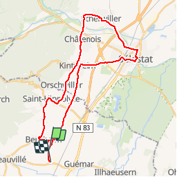
Tocht Fiets van 33 km beschikbaar op Grand Est, Haut-Rhin, Bergheim. Deze tocht wordt voorgesteld door Derrendinger.
Beschrijving
Ballade sympa à réaliser de préférence lors de la manifestation une fois par an en juin car les routes sont fermées aux voitures.
Plaatsbepaling
Land:
France
Regio :
Grand Est
Departement/Provincie :
Haut-Rhin
Gemeente :
Bergheim
Locatie:
Unknown
Vertrek:(Dec)
Vertrek:(UTM)
378714 ; 5339751 (32U) N.
Opmerkingen
Wandeltochten in de omgeving
![Tocht Mountainbike Ribeauvillé - Ribeauvillé Riquewihr - Photo](https://media.geolcdn.com/t/375/260/ext.jpg?maxdim=2&url=https%3A%2F%2Fservices.sitytrail.com%2FGeolivesWS%2FDownloadMedia.ashx%3FTrailID%3D101224%26Media%3D712_1.jpg)
![Mountainbike Mountainbike](https://static1.geolcdn.com/sitytour/trail-icons/202.png)
Ribeauvillé Riquewihr
Mountainbike
Medium
(1)
Ribeauvillé,
Grand Est,
Haut-Rhin,
France
![](/images/other/stat-length.png)
19,3 km | 24 km-effort
1h 30min
![](https://static1.geolcdn.com/siteimages/upload/files/16400158638029165_repeat_loop_refresh_sync_direction_icon.png)
Ja
![Tocht Stappen Hunawihr - Hunawihr - Riquewihr - Photo](https://media.geolcdn.com/t/375/260/ext.jpg?maxdim=2&url=https%3A%2F%2Fstatic1.geolcdn.com%2Fsiteimages%2Fupload%2Ffiles%2F1553511878bg_sport_marche.png)
![Stappen Stappen](https://static1.geolcdn.com/sitytour/trail-icons/101.png)
Hunawihr - Riquewihr
Stappen
Gemakkelijk
(1)
Hunawihr,
Grand Est,
Haut-Rhin,
France
![](/images/other/stat-length.png)
6,3 km | 9 km-effort
2h 15min
![](https://static1.geolcdn.com/siteimages/upload/files/16400158638029165_repeat_loop_refresh_sync_direction_icon.png)
Ja
![Tocht Stappen Riquewihr - Sentier des grands crus - Photo](https://media.geolcdn.com/t/375/260/ext.jpg?maxdim=2&url=https%3A%2F%2Fservices.sitytrail.com%2FGeolivesWS%2FDownloadMedia.ashx%3FTrailID%3D482185%26Media%3D8532cb29-bcf9-4719-bd1f-5f2e4165e237.jpg)
![Stappen Stappen](https://static1.geolcdn.com/sitytour/trail-icons/101.png)
Sentier des grands crus
Stappen
Medium
(2)
Riquewihr,
Grand Est,
Haut-Rhin,
France
![](/images/other/stat-length.png)
11,5 km | 14,4 km-effort
3h 7min
![](https://static1.geolcdn.com/siteimages/upload/files/16400158638029165_repeat_loop_refresh_sync_direction_icon.png)
Ja
![Tocht Stappen Saint-Hippolyte - St hippolyte ht koenigsbourg - Photo](https://media.geolcdn.com/t/375/260/ext.jpg?maxdim=2&url=https%3A%2F%2Fstatic1.geolcdn.com%2Fsiteimages%2Fupload%2Ffiles%2F1553511878bg_sport_marche.png)
![Stappen Stappen](https://static1.geolcdn.com/sitytour/trail-icons/101.png)
St hippolyte ht koenigsbourg
Stappen
Medium
(2)
Saint-Hippolyte,
Grand Est,
Haut-Rhin,
France
![](/images/other/stat-length.png)
12 km | 18,7 km-effort
3h 27min
![](https://static1.geolcdn.com/siteimages/upload/files/16400158638029165_repeat_loop_refresh_sync_direction_icon.png)
Ja
![Tocht Stappen Bergheim - Berghien - Photo](https://media.geolcdn.com/t/375/260/9521df30-806f-464d-a648-d6cec2b043b6.jpg&format=jpg&maxdim=2)
![Stappen Stappen](https://static1.geolcdn.com/sitytour/trail-icons/101.png)
Berghien
Stappen
Gemakkelijk
Bergheim,
Grand Est,
Haut-Rhin,
France
![](/images/other/stat-length.png)
12,1 km | 15,6 km-effort
3h 37min
![](https://static1.geolcdn.com/siteimages/upload/files/16400158638029165_repeat_loop_refresh_sync_direction_icon.png)
Ja
![Tocht Stappen Saint-Hippolyte - St-Hippolyte - Rorschwihr - Grasberg - Bergheim - Reichenberg - Rodern - Photo](https://media.geolcdn.com/t/375/260/44aae6a9-c2ff-44af-afea-23b4ed406441.jpg&format=jpg&maxdim=2)
![Stappen Stappen](https://static1.geolcdn.com/sitytour/trail-icons/101.png)
St-Hippolyte - Rorschwihr - Grasberg - Bergheim - Reichenberg - Rodern
Stappen
Medium
Saint-Hippolyte,
Grand Est,
Haut-Rhin,
France
![](/images/other/stat-length.png)
17,3 km | 22 km-effort
4h 28min
![](https://static1.geolcdn.com/siteimages/upload/files/16400158638029165_repeat_loop_refresh_sync_direction_icon.png)
Ja
![Tocht Mountainbike Bergheim - 1 ère sortie - Photo](https://media.geolcdn.com/t/375/260/57e3216c-710e-4acb-980c-a1a007f80923.jpg&format=jpg&maxdim=2)
![Mountainbike Mountainbike](https://static1.geolcdn.com/sitytour/trail-icons/202.png)
1 ère sortie
Mountainbike
Gemakkelijk
Bergheim,
Grand Est,
Haut-Rhin,
France
![](/images/other/stat-length.png)
12,6 km | 19,1 km-effort
1h 53min
![](https://static1.geolcdn.com/siteimages/upload/files/16400158638029165_repeat_loop_refresh_sync_direction_icon.png)
Ja
![Tocht Stappen Rorschwihr - rorschwihr ac3 - Photo](https://media.geolcdn.com/t/375/260/e1a4436c-3b58-4f87-aa1a-a05aec25fee3.jpg&format=jpg&maxdim=2)
![Stappen Stappen](https://static1.geolcdn.com/sitytour/trail-icons/101.png)
rorschwihr ac3
Stappen
Medium
Rorschwihr,
Grand Est,
Haut-Rhin,
France
![](/images/other/stat-length.png)
6,8 km | 9,2 km-effort
3h 54min
![](https://static1.geolcdn.com/siteimages/upload/files/16400158638029165_repeat_loop_refresh_sync_direction_icon.png)
Ja
![Tocht Stappen Thannenkirch - Taennchel par Thannenkirch - Photo](https://media.geolcdn.com/t/375/260/ext.jpg?maxdim=2&url=https%3A%2F%2Fstatic1.geolcdn.com%2Fsiteimages%2Fupload%2Ffiles%2F1553511878bg_sport_marche.png)
![Stappen Stappen](https://static1.geolcdn.com/sitytour/trail-icons/101.png)
Taennchel par Thannenkirch
Stappen
Medium
(2)
Thannenkirch,
Grand Est,
Haut-Rhin,
France
![](/images/other/stat-length.png)
15,5 km | 23 km-effort
5h 19min
![](https://static1.geolcdn.com/siteimages/upload/files/16400158638029165_repeat_loop_refresh_sync_direction_icon.png)
Ja