![](/images/other/stat-length.png)
![Tocht Stappen Saint-André-de-Lancize - Les Ayres - Col d'Uglas - Photo](https://media.geolcdn.com/t/1900/400/ext.pjpeg?maxdim=2&url=https%3A%2F%2Fstatic1.geolcdn.com%2Fsiteimages%2Fupload%2Ffiles%2F1553511878bg_sport_marche.png)
Les Ayres - Col d'Uglas
jeanluc.smets
Gebruiker
![Lengte](/images/other/stat-length.png)
Lengte
21 km
![Max. hoogte](https://static1.geolcdn.com/siteimages/upload/files/1508320355ic_sort_altitude_max_24dp.png)
Max. hoogte
957 m
![Positief hoogteverschil](https://static1.geolcdn.com/siteimages/upload/files/1508320355ic_sort_den_pos_24dp.png)
Positief hoogteverschil
781 m
![Km-Effort](/images/other/stat-length.png)
Km-Effort
32 km
![Min. hoogte](https://static1.geolcdn.com/siteimages/upload/files/1508320355ic_sort_altitude_min_24dp.png)
Min. hoogte
509 m
![Negatief hoogteverschil](https://static1.geolcdn.com/siteimages/upload/files/1508320355ic_sort_den_neg_24dp.png)
Negatief hoogteverschil
870 m
![Boucle](https://static1.geolcdn.com/siteimages/upload/files/16400158638029165_repeat_loop_refresh_sync_direction_icon.png)
Boucle
Neen
Datum van aanmaak :
2016-06-10 00:00:00.0
Laatste wijziging :
2020-02-13 10:49:56.055
![Stappen](https://static1.geolcdn.com/sitytour/trail-icons/101.png)
7h28
Moeilijkheid : Medium
![Scan deze QR-code om de tocht te openen in de SityTrail-applicatie](https://capi.geolives.com/qq0zvz2zws4bq2lad0pu/sitytour/trails/580471/qr.png?size=200)
Gratisgps-wandelapplicatie
Over ons
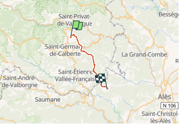
Tocht Stappen van 21 km beschikbaar op Occitanië, Lozère, Saint-André-de-Lancize. Deze tocht wordt voorgesteld door jeanluc.smets.
Beschrijving
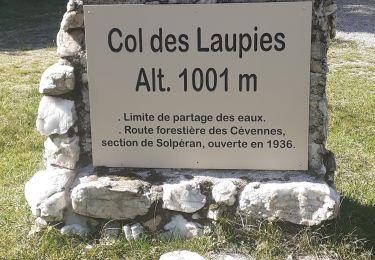
En réalité la randonnée commence au gîte de Valès, avec une belle montée de 1,3 km et 280m de dénivelé jusqu'aux Ayres. Elle se termine au gîte de Mazel à 1 km en desssous du col d'Uglas.
Plaatsbepaling
Land:
France
Regio :
Occitanië
Departement/Provincie :
Lozère
Gemeente :
Saint-André-de-Lancize
Locatie:
Unknown
Vertrek:(Dec)
Vertrek:(UTM)
565895 ; 4899379 (31T) N.
Opmerkingen
Wandeltochten in de omgeving
![Tocht Stappen Saint-Germain-de-Calberte - Stevenson Saint Germain de Calberte Saint Jean du Gard - Photo](https://media.geolcdn.com/t/375/260/ed1caeb9-efdf-4967-a644-947357098d2d.jpg&format=jpg&maxdim=2)
![Stappen Stappen](https://static1.geolcdn.com/sitytour/trail-icons/101.png)
Stevenson Saint Germain de Calberte Saint Jean du Gard
Stappen
Moeilijk
Saint-Germain-de-Calberte,
Occitanië,
Lozère,
France
![](/images/other/stat-length.png)
20 km | 28 km-effort
5h 53min
![](https://static1.geolcdn.com/siteimages/upload/files/16400158638029165_repeat_loop_refresh_sync_direction_icon.png)
Neen
![Tocht Te voet Saint-Germain-de-Calberte - Sentier des Rocs de Galta - Photo](https://media.geolcdn.com/t/375/260/7b519e0d-2e42-4eee-b739-79624893d467.jpeg&format=jpg&maxdim=2)
![Te voet Te voet](https://static1.geolcdn.com/sitytour/trail-icons/100.png)
Sentier des Rocs de Galta
Te voet
Gemakkelijk
Saint-Germain-de-Calberte,
Occitanië,
Lozère,
France
![](/images/other/stat-length.png)
5,4 km | 8 km-effort
1h 49min
![](https://static1.geolcdn.com/siteimages/upload/files/16400158638029165_repeat_loop_refresh_sync_direction_icon.png)
Ja
![Tocht Stappen Saint-Privat-de-Vallongue - 48 le pont de champermal le 06/02/25 - Photo](https://media.geolcdn.com/t/375/260/e61f9507-a772-4062-89e7-53c21ae774bc.jpg&format=jpg&maxdim=2)
![Stappen Stappen](https://static1.geolcdn.com/sitytour/trail-icons/101.png)
48 le pont de champermal le 06/02/25
Stappen
Zeer moeilijk
Saint-Privat-de-Vallongue,
Occitanië,
Lozère,
France
![](/images/other/stat-length.png)
13,9 km | 21 km-effort
6h 44min
![](https://static1.geolcdn.com/siteimages/upload/files/16400158638029165_repeat_loop_refresh_sync_direction_icon.png)
Ja
![Tocht Stappen Saint-Germain-de-Calberte - st germain de calberte - Photo](https://media.geolcdn.com/t/375/260/87eeb041-cc74-4ba2-9ba8-32045268c777.jpg&format=jpg&maxdim=2)
![Stappen Stappen](https://static1.geolcdn.com/sitytour/trail-icons/101.png)
st germain de calberte
Stappen
Zeer moeilijk
Saint-Germain-de-Calberte,
Occitanië,
Lozère,
France
![](/images/other/stat-length.png)
18,4 km | 28 km-effort
6h 25min
![](https://static1.geolcdn.com/siteimages/upload/files/16400158638029165_repeat_loop_refresh_sync_direction_icon.png)
Ja
![Tocht Te voet Saint-Germain-de-Calberte - La Flandonenque - Photo](https://media.geolcdn.com/t/375/260/a5cf2c6f-e67e-448b-83ec-9810d7980fa9.jpeg&format=jpg&maxdim=2)
![Te voet Te voet](https://static1.geolcdn.com/sitytour/trail-icons/100.png)
La Flandonenque
Te voet
Gemakkelijk
Saint-Germain-de-Calberte,
Occitanië,
Lozère,
France
![](/images/other/stat-length.png)
9,2 km | 13,1 km-effort
2h 57min
![](https://static1.geolcdn.com/siteimages/upload/files/16400158638029165_repeat_loop_refresh_sync_direction_icon.png)
Ja
![Tocht Mountainbike Saint-Germain-de-Calberte - St Germain de Calberte - St Jean du Gard - Photo](https://media.geolcdn.com/t/375/260/ext.jpg?maxdim=2&url=https%3A%2F%2Fstatic1.geolcdn.com%2Fsiteimages%2Fupload%2Ffiles%2F1524743154velo.jpg)
![Mountainbike Mountainbike](https://static1.geolcdn.com/sitytour/trail-icons/202.png)
St Germain de Calberte - St Jean du Gard
Mountainbike
Moeilijk
(1)
Saint-Germain-de-Calberte,
Occitanië,
Lozère,
France
![](/images/other/stat-length.png)
32 km | 44 km-effort
2h 46min
![](https://static1.geolcdn.com/siteimages/upload/files/16400158638029165_repeat_loop_refresh_sync_direction_icon.png)
Neen
![Tocht sport Saint-Germain-de-Calberte - Saint-Jean du Gard - Photo](https://media.geolcdn.com/t/375/260/4f2ac59f-3f26-44c5-bfe4-509a884973fb.jpg&format=jpg&maxdim=2)
Saint-Jean du Gard
sport
Heel gemakkelijk
Saint-Germain-de-Calberte,
Occitanië,
Lozère,
France
![](/images/other/stat-length.png)
23 km | 34 km-effort
Onbekend
![](https://static1.geolcdn.com/siteimages/upload/files/16400158638029165_repeat_loop_refresh_sync_direction_icon.png)
Neen
![Tocht Stappen Saint-André-de-Lancize - Signal de Ventavon - Photo](https://media.geolcdn.com/t/375/260/ce311126-1110-4f34-a143-1ff37abb84c2.jpg&format=jpg&maxdim=2)
![Stappen Stappen](https://static1.geolcdn.com/sitytour/trail-icons/101.png)
Signal de Ventavon
Stappen
Gemakkelijk
Saint-André-de-Lancize,
Occitanië,
Lozère,
France
![](/images/other/stat-length.png)
13,8 km | 21 km-effort
4h 2min
![](https://static1.geolcdn.com/siteimages/upload/files/16400158638029165_repeat_loop_refresh_sync_direction_icon.png)
Ja
![Tocht Stappen Saint-Germain-de-Calberte - Gard - Photo](https://media.geolcdn.com/t/375/260/b0debdc6-1e5e-442a-94ea-69fd4741f04e.jpg&format=jpg&maxdim=2)
![Stappen Stappen](https://static1.geolcdn.com/sitytour/trail-icons/101.png)
Gard
Stappen
Zeer moeilijk
Saint-Germain-de-Calberte,
Occitanië,
Lozère,
France
![](/images/other/stat-length.png)
22 km | 33 km-effort
6h 33min
![](https://static1.geolcdn.com/siteimages/upload/files/16400158638029165_repeat_loop_refresh_sync_direction_icon.png)
Neen