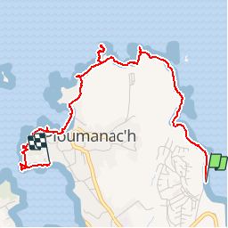
![](/images/other/stat-length.png)
![Tocht Stappen Perros-Guirec - Découverte de la Côte de Granit Rose - Photo](https://media.geolcdn.com/t/1900/400/ext.pjpeg?maxdim=2&url=https%3A%2F%2Fservices.sitytrail.com%2FGeolivesWS%2FDownloadMedia.ashx%3FTrailID%3D577570%26Media%3De60710c1-30c3-43c5-ac42-38fec2e92d3a.jpg)
Découverte de la Côte de Granit Rose
pascalou73
Gebruiker GUIDE
![Lengte](/images/other/stat-length.png)
![Max. hoogte](https://static1.geolcdn.com/siteimages/upload/files/1508320355ic_sort_altitude_max_24dp.png)
![Positief hoogteverschil](https://static1.geolcdn.com/siteimages/upload/files/1508320355ic_sort_den_pos_24dp.png)
![Km-Effort](/images/other/stat-length.png)
![Min. hoogte](https://static1.geolcdn.com/siteimages/upload/files/1508320355ic_sort_altitude_min_24dp.png)
![Negatief hoogteverschil](https://static1.geolcdn.com/siteimages/upload/files/1508320355ic_sort_den_neg_24dp.png)
![Boucle](https://static1.geolcdn.com/siteimages/upload/files/16400158638029165_repeat_loop_refresh_sync_direction_icon.png)
![Stappen](https://static1.geolcdn.com/sitytour/trail-icons/101.png)
1h01
Moeilijkheid : Gemakkelijk
![Scan deze QR-code om de tocht te openen in de SityTrail-applicatie](https://capi.geolives.com/qq0zvz2zws4bq2lad0pu/sitytour/trails/577570/qr.png?size=200)
Gratisgps-wandelapplicatie
Over ons
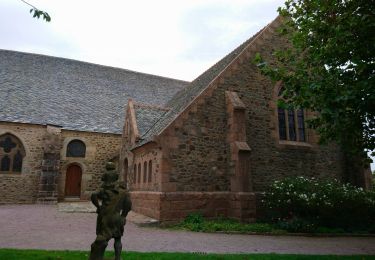
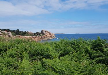
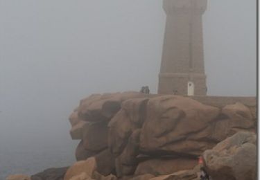
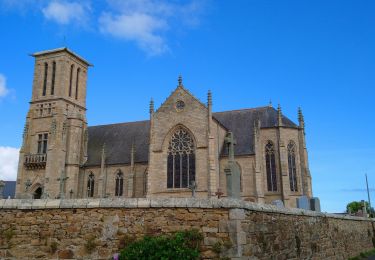
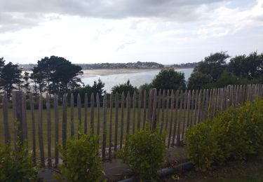
Tocht Stappen van 3,9 km beschikbaar op Bretagne, Côtes-d'Armor, Perros-Guirec. Deze tocht wordt voorgesteld door pascalou73.
Beschrijving
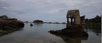
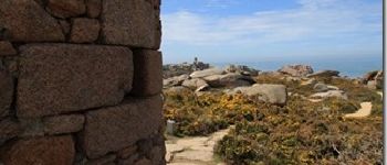
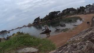
Au départ du camping le ranolien, vous pourrez vous admirer un magnifique décor de pierre de granit rose qui vous emmènera au village préféré 2015 des francais :Ploumanach où vous pourrez vous restaurer avec de bons produits régionaux. Belle découverte de la région.
Plaatsbepaling
Opmerkingen
Wandeltochten in de omgeving
![Tocht Stappen Perros-Guirec - Perros-Guirec - GR34 - 11.1km 185m 2h50 - 2023 09 08 - Photo](https://media.geolcdn.com/t/375/260/d1728063-b6c3-4241-bba7-0eab61cebb20.jpg&format=jpg&maxdim=2)
![Stappen Stappen](https://static1.geolcdn.com/sitytour/trail-icons/101.png)
Stappen
![](/images/other/stat-length.png)
![](https://static1.geolcdn.com/siteimages/upload/files/16400158638029165_repeat_loop_refresh_sync_direction_icon.png)
![Tocht Stappen Trégastel - Trégastel - GR34 Île Renote Moulin à marée Chapelle de Gorgon - 13.8km 100m 3h35 - 2023 09 07 - Photo](https://media.geolcdn.com/t/375/260/f7b585bc-cd92-4f03-b6f8-635e10f5e6be.jpg&format=jpg&maxdim=2)
![Stappen Stappen](https://static1.geolcdn.com/sitytour/trail-icons/101.png)
Stappen
![](/images/other/stat-length.png)
![](https://static1.geolcdn.com/siteimages/upload/files/16400158638029165_repeat_loop_refresh_sync_direction_icon.png)
![Tocht Stappen Perros-Guirec - la côte de granit rose à Ploumanach - Photo](https://media.geolcdn.com/t/375/260/64deb34e-d59c-4f9a-95ec-bcb98ff541ad.jpg&format=jpg&maxdim=2)
![Stappen Stappen](https://static1.geolcdn.com/sitytour/trail-icons/101.png)
Stappen
![](/images/other/stat-length.png)
![](https://static1.geolcdn.com/siteimages/upload/files/16400158638029165_repeat_loop_refresh_sync_direction_icon.png)
![Tocht Stappen Perros-Guirec - Les sentiers de Ploumanac'h - Photo](https://media.geolcdn.com/t/375/260/ext.jpg?maxdim=2&url=https%3A%2F%2Fservices.sitytrail.com%2FGeolivesWS%2FDownloadMedia.ashx%3FTrailID%3D317019%26Media%3D16161_1.jpg)
![Stappen Stappen](https://static1.geolcdn.com/sitytour/trail-icons/101.png)
Stappen
![](/images/other/stat-length.png)
![](https://static1.geolcdn.com/siteimages/upload/files/16400158638029165_repeat_loop_refresh_sync_direction_icon.png)
![Tocht Stappen Louannec - Louannec - GR34 PR - 11.5km 185m 3h00 (40mn) - 2023 09 14 - Photo](https://media.geolcdn.com/t/375/260/e980ede6-67ca-4aa3-94c9-619423761500.jpg&format=jpg&maxdim=2)
![Stappen Stappen](https://static1.geolcdn.com/sitytour/trail-icons/101.png)
Stappen
![](/images/other/stat-length.png)
![](https://static1.geolcdn.com/siteimages/upload/files/16400158638029165_repeat_loop_refresh_sync_direction_icon.png)
![Tocht Stappen Trégastel - Trégastel - GR34 Ploumanac'h Kasino de Perros-Guirec - 11.7km 200m 2h55 (50mn) - 2023 09 08 - Photo](https://media.geolcdn.com/t/375/260/3132b43e-4920-4682-bf35-15b1d429cbae.jpg&format=jpg&maxdim=2)
![Stappen Stappen](https://static1.geolcdn.com/sitytour/trail-icons/101.png)
Stappen
![](/images/other/stat-length.png)
![](https://static1.geolcdn.com/siteimages/upload/files/16400158638029165_repeat_loop_refresh_sync_direction_icon.png)
![Tocht Stappen Pleumeur-Bodou - Pleumeur-Bodou - GR34 Chapelle Saint-Samson - 7.7km 60m 1h55 - 2023 09 06 - Photo](https://media.geolcdn.com/t/375/260/5d74374c-67e8-400e-845c-98d92708147a.jpg&format=jpg&maxdim=2)
![Stappen Stappen](https://static1.geolcdn.com/sitytour/trail-icons/101.png)
Stappen
![](/images/other/stat-length.png)
![](https://static1.geolcdn.com/siteimages/upload/files/16400158638029165_repeat_loop_refresh_sync_direction_icon.png)
![Tocht Fietstoerisme Pleumeur-Bodou - Landrellec à kercoz - Photo](https://media.geolcdn.com/t/375/260/9edc18fe-d348-4dcd-a457-97cbb66b8768.jpg&format=jpg&maxdim=2)
![Fietstoerisme Fietstoerisme](https://static1.geolcdn.com/sitytour/trail-icons/204.png)
Fietstoerisme
![](/images/other/stat-length.png)
![](https://static1.geolcdn.com/siteimages/upload/files/16400158638029165_repeat_loop_refresh_sync_direction_icon.png)
![Tocht Stappen Trégastel - GR34-EtapeIII-J05 - Photo](https://media.geolcdn.com/t/375/260/ext.jpg?maxdim=2&url=https%3A%2F%2Fstatic1.geolcdn.com%2Fsiteimages%2Fupload%2Ffiles%2F1553511878bg_sport_marche.png)
![Stappen Stappen](https://static1.geolcdn.com/sitytour/trail-icons/101.png)
Stappen
![](/images/other/stat-length.png)
![](https://static1.geolcdn.com/siteimages/upload/files/16400158638029165_repeat_loop_refresh_sync_direction_icon.png)