![](/images/other/stat-length.png)
![Tocht Fiets Mangonville - mangonville2 - Photo](https://media.geolcdn.com/t/1900/400/ext.pjpeg?maxdim=2&url=https%3A%2F%2Fstatic1.geolcdn.com%2Fsiteimages%2Fupload%2Ffiles%2F1524743154velo.jpg)
mangonville2
zibane54
Gebruiker
![Lengte](/images/other/stat-length.png)
Lengte
43 km
![Max. hoogte](https://static1.geolcdn.com/siteimages/upload/files/1508320355ic_sort_altitude_max_24dp.png)
Max. hoogte
355 m
![Positief hoogteverschil](https://static1.geolcdn.com/siteimages/upload/files/1508320355ic_sort_den_pos_24dp.png)
Positief hoogteverschil
444 m
![Km-Effort](/images/other/stat-length.png)
Km-Effort
49 km
![Min. hoogte](https://static1.geolcdn.com/siteimages/upload/files/1508320355ic_sort_altitude_min_24dp.png)
Min. hoogte
248 m
![Negatief hoogteverschil](https://static1.geolcdn.com/siteimages/upload/files/1508320355ic_sort_den_neg_24dp.png)
Negatief hoogteverschil
445 m
![Boucle](https://static1.geolcdn.com/siteimages/upload/files/16400158638029165_repeat_loop_refresh_sync_direction_icon.png)
Boucle
Ja
Datum van aanmaak :
2016-05-15 00:00:00.0
Laatste wijziging :
2016-05-15 00:00:00.0
![Fiets](https://static1.geolcdn.com/sitytour/trail-icons/200.png)
2h00
Moeilijkheid : Medium
![Scan deze QR-code om de tocht te openen in de SityTrail-applicatie](https://capi.geolives.com/qq0zvz2zws4bq2lad0pu/sitytour/trails/569208/qr.png?size=200)
Gratisgps-wandelapplicatie
Over ons
Tocht Fiets van 43 km beschikbaar op Grand Est, Meurthe-et-Moselle, Mangonville. Deze tocht wordt voorgesteld door zibane54.
Beschrijving
une belle boucle dans la campagne bayonnaise. a Bainville au retour emprunter le halage a droite avant le canal
Plaatsbepaling
Land:
France
Regio :
Grand Est
Departement/Provincie :
Meurthe-et-Moselle
Gemeente :
Mangonville
Locatie:
Unknown
Vertrek:(Dec)
Vertrek:(UTM)
299601 ; 5370563 (32U) N.
Opmerkingen
Wandeltochten in de omgeving
![Tocht Fiets Mangonville - mangonville - Photo](https://media.geolcdn.com/t/375/260/ext.jpg?maxdim=2&url=https%3A%2F%2Fstatic1.geolcdn.com%2Fsiteimages%2Fupload%2Ffiles%2F1524743154velo.jpg)
![Fiets Fiets](https://static1.geolcdn.com/sitytour/trail-icons/200.png)
mangonville
Fiets
Gemakkelijk
(2)
Mangonville,
Grand Est,
Meurthe-et-Moselle,
France
![](/images/other/stat-length.png)
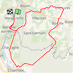
43 km | 50 km-effort
2h 52min
![](https://static1.geolcdn.com/siteimages/upload/files/16400158638029165_repeat_loop_refresh_sync_direction_icon.png)
Neen
![Tocht Stappen Bayon - Etang Bayon - Photo](https://media.geolcdn.com/t/375/260/ext.jpg?maxdim=2&url=https%3A%2F%2Fstatic1.geolcdn.com%2Fsiteimages%2Fupload%2Ffiles%2F1553511878bg_sport_marche.png)
![Stappen Stappen](https://static1.geolcdn.com/sitytour/trail-icons/101.png)
Etang Bayon
Stappen
Gemakkelijk
Bayon,
Grand Est,
Meurthe-et-Moselle,
France
![](/images/other/stat-length.png)
3,4 km | 3,6 km-effort
1h 14min
![](https://static1.geolcdn.com/siteimages/upload/files/16400158638029165_repeat_loop_refresh_sync_direction_icon.png)
Ja
![Tocht Elektrische fiets Bainville-aux-Miroirs - sortie vtt sion 04082022 - Photo](https://media.geolcdn.com/t/375/260/ext.jpg?maxdim=2&url=https%3A%2F%2Fstatic1.geolcdn.com%2Fsiteimages%2Fupload%2Ffiles%2F1524743154velo.jpg)
![Elektrische fiets Elektrische fiets](https://static1.geolcdn.com/sitytour/trail-icons/205.png)
sortie vtt sion 04082022
Elektrische fiets
Moeilijk
Bainville-aux-Miroirs,
Grand Est,
Meurthe-et-Moselle,
France
![](/images/other/stat-length.png)
51 km | 62 km-effort
3h 22min
![](https://static1.geolcdn.com/siteimages/upload/files/16400158638029165_repeat_loop_refresh_sync_direction_icon.png)
Ja
![Tocht Elektrische fiets Bainville-aux-Miroirs - sortie vtt 08052022 luca - Photo](https://media.geolcdn.com/t/375/260/ext.jpg?maxdim=2&url=https%3A%2F%2Fstatic1.geolcdn.com%2Fsiteimages%2Fupload%2Ffiles%2F1524743154velo.jpg)
![Elektrische fiets Elektrische fiets](https://static1.geolcdn.com/sitytour/trail-icons/205.png)
sortie vtt 08052022 luca
Elektrische fiets
Medium
Bainville-aux-Miroirs,
Grand Est,
Meurthe-et-Moselle,
France
![](/images/other/stat-length.png)
42 km | 50 km-effort
2h 36min
![](https://static1.geolcdn.com/siteimages/upload/files/16400158638029165_repeat_loop_refresh_sync_direction_icon.png)
Ja
![Tocht Paardrijden Froville - acpl chez Karine et Danielle froville - Photo](https://media.geolcdn.com/t/375/260/ext.jpg?maxdim=2&url=https%3A%2F%2Fstatic1.geolcdn.com%2Fsiteimages%2Fupload%2Ffiles%2F1524743154cheval.jpg)
![Paardrijden Paardrijden](https://static1.geolcdn.com/sitytour/trail-icons/301.png)
acpl chez Karine et Danielle froville
Paardrijden
Medium
Froville,
Grand Est,
Meurthe-et-Moselle,
France
![](/images/other/stat-length.png)
21 km | 24 km-effort
3h 11min
![](https://static1.geolcdn.com/siteimages/upload/files/16400158638029165_repeat_loop_refresh_sync_direction_icon.png)
Ja
![Tocht Stappen Mangonville - pipistrelle - Photo](https://media.geolcdn.com/t/375/260/ext.jpg?maxdim=2&url=https%3A%2F%2Fstatic1.geolcdn.com%2Fsiteimages%2Fupload%2Ffiles%2F1553511878bg_sport_marche.png)
![Stappen Stappen](https://static1.geolcdn.com/sitytour/trail-icons/101.png)
pipistrelle
Stappen
Mangonville,
Grand Est,
Meurthe-et-Moselle,
France
![](/images/other/stat-length.png)
9,9 km | 11,9 km-effort
2h 45min
![](https://static1.geolcdn.com/siteimages/upload/files/16400158638029165_repeat_loop_refresh_sync_direction_icon.png)
Ja
![Tocht Stappen Bayon - la saussaie Bayon 10km - Photo](https://media.geolcdn.com/t/375/260/4b873303-590d-4338-9afc-7d6de0f50bbd.jpg&format=jpg&maxdim=2)
![Stappen Stappen](https://static1.geolcdn.com/sitytour/trail-icons/101.png)
la saussaie Bayon 10km
Stappen
Medium
(1)
Bayon,
Grand Est,
Meurthe-et-Moselle,
France
![](/images/other/stat-length.png)
9,9 km | 11,1 km-effort
2h 36min
![](https://static1.geolcdn.com/siteimages/upload/files/16400158638029165_repeat_loop_refresh_sync_direction_icon.png)
Ja
![Tocht Stappen Virecourt - Bayon Charmes - Photo](https://media.geolcdn.com/t/375/260/ext.jpg?maxdim=2&url=https%3A%2F%2Fstatic1.geolcdn.com%2Fsiteimages%2Fupload%2Ffiles%2F1553511878bg_sport_marche.png)
![Stappen Stappen](https://static1.geolcdn.com/sitytour/trail-icons/101.png)
Bayon Charmes
Stappen
Medium
Virecourt,
Grand Est,
Meurthe-et-Moselle,
France
![](/images/other/stat-length.png)
22 km | 25 km-effort
4h 56min
![](https://static1.geolcdn.com/siteimages/upload/files/16400158638029165_repeat_loop_refresh_sync_direction_icon.png)
Neen
![Tocht Stappen Roville-devant-Bayon - Roville devant Bayon - Photo](https://media.geolcdn.com/t/375/260/ext.jpg?maxdim=2&url=https%3A%2F%2Fstatic1.geolcdn.com%2Fsiteimages%2Fupload%2Ffiles%2F1553511878bg_sport_marche.png)
![Stappen Stappen](https://static1.geolcdn.com/sitytour/trail-icons/101.png)
Roville devant Bayon
Stappen
Gemakkelijk
Roville-devant-Bayon,
Grand Est,
Meurthe-et-Moselle,
France
![](/images/other/stat-length.png)
12,9 km | 15,7 km-effort
3h 25min
![](https://static1.geolcdn.com/siteimages/upload/files/16400158638029165_repeat_loop_refresh_sync_direction_icon.png)
Ja