![](/images/other/stat-length.png)
![Tocht Stappen Saint-Georges-de-Reintembault - St-Georges de Reintembault - Photo](https://media.geolcdn.com/t/1900/400/ext.pjpeg?maxdim=2&url=https%3A%2F%2Fstatic1.geolcdn.com%2Fsiteimages%2Fupload%2Ffiles%2F1553511878bg_sport_marche.png)
St-Georges de Reintembault
neoroll44
Gebruiker
![Lengte](/images/other/stat-length.png)
![Max. hoogte](https://static1.geolcdn.com/siteimages/upload/files/1508320355ic_sort_altitude_max_24dp.png)
![Positief hoogteverschil](https://static1.geolcdn.com/siteimages/upload/files/1508320355ic_sort_den_pos_24dp.png)
![Km-Effort](/images/other/stat-length.png)
![Min. hoogte](https://static1.geolcdn.com/siteimages/upload/files/1508320355ic_sort_altitude_min_24dp.png)
![Negatief hoogteverschil](https://static1.geolcdn.com/siteimages/upload/files/1508320355ic_sort_den_neg_24dp.png)
![Boucle](https://static1.geolcdn.com/siteimages/upload/files/16400158638029165_repeat_loop_refresh_sync_direction_icon.png)
![Stappen](https://static1.geolcdn.com/sitytour/trail-icons/101.png)
2h20
Moeilijkheid : Medium
![Scan deze QR-code om de tocht te openen in de SityTrail-applicatie](https://capi.geolives.com/qq0zvz2zws4bq2lad0pu/sitytour/trails/558462/qr.png?size=200)
Gratisgps-wandelapplicatie
Over ons
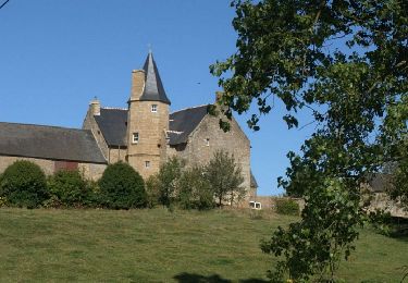
Tocht Stappen van 9,2 km beschikbaar op Bretagne, Ille-et-Vilaine, Saint-Georges-de-Reintembault. Deze tocht wordt voorgesteld door neoroll44.
Beschrijving
Circuit de la toile à l'agri-culture.
Départ parking du complexe des Ajoncs d’Or (rue de l’Épine).
Prendre une petite allée derrière le panneau du circuit.
Partir à droite en longeant la route sur une bande enherbée. Tourner à gauche dans un chemin creux.
Tourner à gauche sur la route, puis prendre le 1er chemin à droite.
Prendre à droite sur la D 16 puis à gauche un chemin qui mène au village de Moulanou. Prendre le sentier à droite.
Prendre à gauche au croisement et à droite pour arriver à La Giraudais.
Longer la dernière maison sur la droite. À l’intersection suivante,
prendre à gauche le circuit pour une boucle jusqu’à La Petite Giraudais. Revenir sur ses pas et continuer tout droit jusqu’au
Grand Couveloup.
Après le village tourner à droite.
Variante en jaune : poursuivre vers Le Champ Hec. Prendre à droite
puis à nouveau à droite un chemin en terre jusqu’à La Thiolais.
Traverser le village puis prendre à nouveau à droite. Après Les Hotellières prendre à gauche.
Retrouver la route communale, aller vers la gauche puis prendre le
chemin à droite.
Au niveau des Ardennes traverser la petite route pour poursuivre sur
le chemin se trouvant juste en face jusqu’à La Foire. Dans le village,
prendre sur la droite. Passer La Ville en Bois, redescendre sur la
droite par le terrain enherbé jusqu’au moulin de Colas et remonter au parking en empruntant l’allée du départ.
Plaatsbepaling
Opmerkingen
Wandeltochten in de omgeving
![Tocht Te voet Monthault - Paysages et couleurs - Photo](https://media.geolcdn.com/t/375/260/c798034c-7fdc-45d8-a884-df843ba3721e.jpeg&format=jpg&maxdim=2)
![Te voet Te voet](https://static1.geolcdn.com/sitytour/trail-icons/100.png)
Te voet
![](/images/other/stat-length.png)
![](https://static1.geolcdn.com/siteimages/upload/files/16400158638029165_repeat_loop_refresh_sync_direction_icon.png)
![Tocht Stappen Mellé - Sentier Pierre & Nature - Mellé - Photo](https://media.geolcdn.com/t/375/260/ext.jpg?maxdim=2&url=https%3A%2F%2Fservices.sitytrail.com%2FGeolivesWS%2FDownloadMedia.ashx%3FTrailID%3D317764%26Media%3D17076_6.jpg)
![Stappen Stappen](https://static1.geolcdn.com/sitytour/trail-icons/101.png)
Stappen
![](/images/other/stat-length.png)
![](https://static1.geolcdn.com/siteimages/upload/files/16400158638029165_repeat_loop_refresh_sync_direction_icon.png)
![Tocht Stappen Le Ferré - Le Ferré_Pors aux chouans - Photo](https://media.geolcdn.com/t/375/260/ext.jpg?maxdim=2&url=https%3A%2F%2Fservices.sitytrail.com%2FGeolivesWS%2FDownloadMedia.ashx%3FTrailID%3D557506%26Media%3Df5197baf-1246-4640-bd53-f30de85ed0db.jpg)
![Stappen Stappen](https://static1.geolcdn.com/sitytour/trail-icons/101.png)
Stappen
![](/images/other/stat-length.png)
![](https://static1.geolcdn.com/siteimages/upload/files/16400158638029165_repeat_loop_refresh_sync_direction_icon.png)
![Tocht Stappen Saint-Georges-de-Reintembault - De la toile à l'agriculture (10 kms) - Saint Georges de Reintembault - Photo](https://media.geolcdn.com/t/375/260/ext.jpg?maxdim=2&url=https%3A%2F%2Fservices.sitytrail.com%2FGeolivesWS%2FDownloadMedia.ashx%3FTrailID%3D112677%26Media%3D11459_1.jpg)
![Stappen Stappen](https://static1.geolcdn.com/sitytour/trail-icons/101.png)
Stappen
![](/images/other/stat-length.png)
![](https://static1.geolcdn.com/siteimages/upload/files/16400158638029165_repeat_loop_refresh_sync_direction_icon.png)
![Tocht Stappen Saint-Georges-de-Reintembault - De la toile à l'agriculture (7 kms) - Saint Georges de Reintembault - Photo](https://media.geolcdn.com/t/375/260/ext.jpg?maxdim=2&url=https%3A%2F%2Fservices.sitytrail.com%2FGeolivesWS%2FDownloadMedia.ashx%3FTrailID%3D112676%26Media%3D11458_1.jpg)
![Stappen Stappen](https://static1.geolcdn.com/sitytour/trail-icons/101.png)
Stappen
![](/images/other/stat-length.png)
![](https://static1.geolcdn.com/siteimages/upload/files/16400158638029165_repeat_loop_refresh_sync_direction_icon.png)
![Tocht Stappen Monthault - Monthault - Photo](https://media.geolcdn.com/t/375/260/ext.jpg?maxdim=2&url=https%3A%2F%2Fstatic1.geolcdn.com%2Fsiteimages%2Fupload%2Ffiles%2F1553511878bg_sport_marche.png)
![Stappen Stappen](https://static1.geolcdn.com/sitytour/trail-icons/101.png)
Stappen
![](/images/other/stat-length.png)
![](https://static1.geolcdn.com/siteimages/upload/files/16400158638029165_repeat_loop_refresh_sync_direction_icon.png)
![Tocht Stappen Mellé - Mellé - Photo](https://media.geolcdn.com/t/375/260/ext.jpg?maxdim=2&url=https%3A%2F%2Fservices.sitytrail.com%2FGeolivesWS%2FDownloadMedia.ashx%3FTrailID%3D558422%26Media%3D6c7bf722-306f-432a-a7a2-489322fb51f5.jpg)
![Stappen Stappen](https://static1.geolcdn.com/sitytour/trail-icons/101.png)
Stappen
![](/images/other/stat-length.png)
![](https://static1.geolcdn.com/siteimages/upload/files/16400158638029165_repeat_loop_refresh_sync_direction_icon.png)
![Tocht Stappen Mellé - 20200103_la roche au diable - Photo](https://media.geolcdn.com/t/375/260/d655741f-8e8e-4b5d-b556-c368deb30f05.jpg&format=jpg&maxdim=2)
![Stappen Stappen](https://static1.geolcdn.com/sitytour/trail-icons/101.png)
Stappen
![](/images/other/stat-length.png)
![](https://static1.geolcdn.com/siteimages/upload/files/16400158638029165_repeat_loop_refresh_sync_direction_icon.png)
![Tocht Stappen Poilley - Poilley - Photo](https://media.geolcdn.com/t/375/260/ext.jpg?maxdim=2&url=https%3A%2F%2Fstatic1.geolcdn.com%2Fsiteimages%2Fupload%2Ffiles%2F1553511878bg_sport_marche.png)
![Stappen Stappen](https://static1.geolcdn.com/sitytour/trail-icons/101.png)
Stappen
![](/images/other/stat-length.png)
![](https://static1.geolcdn.com/siteimages/upload/files/16400158638029165_repeat_loop_refresh_sync_direction_icon.png)