![](/images/other/stat-length.png)
Ruffec_Logis
neoroll44
Gebruiker
![Lengte](/images/other/stat-length.png)
Lengte
17,3 km
![Max. hoogte](https://static1.geolcdn.com/siteimages/upload/files/1508320355ic_sort_altitude_max_24dp.png)
Max. hoogte
147 m
![Positief hoogteverschil](https://static1.geolcdn.com/siteimages/upload/files/1508320355ic_sort_den_pos_24dp.png)
Positief hoogteverschil
176 m
![Km-Effort](/images/other/stat-length.png)
Km-Effort
19,7 km
![Min. hoogte](https://static1.geolcdn.com/siteimages/upload/files/1508320355ic_sort_altitude_min_24dp.png)
Min. hoogte
87 m
![Negatief hoogteverschil](https://static1.geolcdn.com/siteimages/upload/files/1508320355ic_sort_den_neg_24dp.png)
Negatief hoogteverschil
176 m
![Boucle](https://static1.geolcdn.com/siteimages/upload/files/16400158638029165_repeat_loop_refresh_sync_direction_icon.png)
Boucle
Ja
Datum van aanmaak :
2016-04-20 00:00:00.0
Laatste wijziging :
2016-04-20 00:00:00.0
![Stappen](https://static1.geolcdn.com/sitytour/trail-icons/101.png)
4h20
Moeilijkheid : Medium
![Scan deze QR-code om de tocht te openen in de SityTrail-applicatie](https://capi.geolives.com/qq0zvz2zws4bq2lad0pu/sitytour/trails/556592/qr.png?size=200)
Gratisgps-wandelapplicatie
Over ons
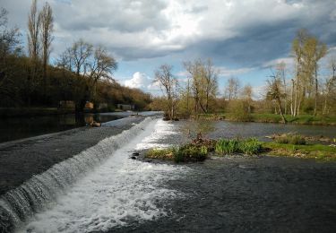
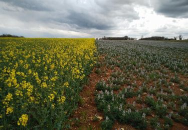
Tocht Stappen van 17,3 km beschikbaar op Nieuw-Aquitanië, Charente, Ruffec. Deze tocht wordt voorgesteld door neoroll44.
Beschrijving
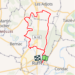
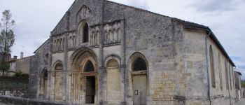
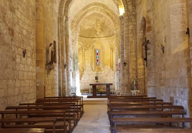
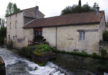
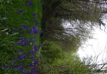
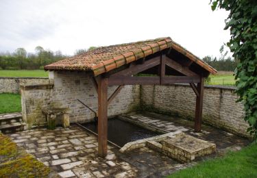
Circuit des logis (violet). Départ de l'église St-André, puis la forêt privée de Ruffec, le bois de vallons et les logis.
Plaatsbepaling
Land:
France
Regio :
Nieuw-Aquitanië
Departement/Provincie :
Charente
Gemeente :
Ruffec
Locatie:
Unknown
Vertrek:(Dec)
Vertrek:(UTM)
283497 ; 5100896 (31T) N.
Opmerkingen
Wandeltochten in de omgeving
![Tocht Hybride fiets Condac - rejellant chassane - Photo](https://media.geolcdn.com/t/375/260/f941dbf9-6f50-4e7d-8c40-12817a339d98.jpg&format=jpg&maxdim=2)
![Hybride fiets Hybride fiets](https://static1.geolcdn.com/sitytour/trail-icons/203.png)
rejellant chassane
Hybride fiets
Gemakkelijk
Condac,
Nieuw-Aquitanië,
Charente,
France
![](/images/other/stat-length.png)
17,5 km | 19,6 km-effort
5h 11min
![](https://static1.geolcdn.com/siteimages/upload/files/16400158638029165_repeat_loop_refresh_sync_direction_icon.png)
Neen
![Tocht Stappen Condac - Condac - Photo](https://media.geolcdn.com/t/375/260/ext.jpg?maxdim=2&url=https%3A%2F%2Fservices.sitytrail.com%2FGeolivesWS%2FDownloadMedia.ashx%3FTrailID%3D556317%26Media%3Ddcadb249-373c-4f07-b689-15b2cfca5ca5.JPG)
![Stappen Stappen](https://static1.geolcdn.com/sitytour/trail-icons/101.png)
![Tocht Stappen Ruffec - Ruffec_Forêt - Photo](https://media.geolcdn.com/t/375/260/ext.jpg?maxdim=2&url=https%3A%2F%2Fservices.sitytrail.com%2FGeolivesWS%2FDownloadMedia.ashx%3FTrailID%3D554305%26Media%3D4db66742-d552-44a5-85d9-ad956cf37102.JPG)
![Stappen Stappen](https://static1.geolcdn.com/sitytour/trail-icons/101.png)
Ruffec_Forêt
Stappen
Gemakkelijk
Ruffec,
Nieuw-Aquitanië,
Charente,
France
![](/images/other/stat-length.png)
8,5 km | 10 km-effort
2h 20min
![](https://static1.geolcdn.com/siteimages/upload/files/16400158638029165_repeat_loop_refresh_sync_direction_icon.png)
Ja
![Tocht Stappen Condac - Condac_Bioussac_Barro - Photo](https://media.geolcdn.com/t/375/260/ext.jpg?maxdim=2&url=https%3A%2F%2Fservices.sitytrail.com%2FGeolivesWS%2FDownloadMedia.ashx%3FTrailID%3D554281%26Media%3Dad2440e1-83f4-4ca4-9ca5-3c359047fce4.JPG)
![Stappen Stappen](https://static1.geolcdn.com/sitytour/trail-icons/101.png)
Condac_Bioussac_Barro
Stappen
Medium
Condac,
Nieuw-Aquitanië,
Charente,
France
![](/images/other/stat-length.png)
26 km | 31 km-effort
6h 40min
![](https://static1.geolcdn.com/siteimages/upload/files/16400158638029165_repeat_loop_refresh_sync_direction_icon.png)
Ja
![Tocht Stappen Ruffec - Ruffec_Jardins - Photo](https://media.geolcdn.com/t/375/260/ext.jpg?maxdim=2&url=https%3A%2F%2Fservices.sitytrail.com%2FGeolivesWS%2FDownloadMedia.ashx%3FTrailID%3D555645%26Media%3Da0f43bbb-0193-406e-8ccd-743115a33ead.jpg)
![Stappen Stappen](https://static1.geolcdn.com/sitytour/trail-icons/101.png)
Ruffec_Jardins
Stappen
Gemakkelijk
(2)
Ruffec,
Nieuw-Aquitanië,
Charente,
France
![](/images/other/stat-length.png)
5,4 km | 6,2 km-effort
1h 30min
![](https://static1.geolcdn.com/siteimages/upload/files/16400158638029165_repeat_loop_refresh_sync_direction_icon.png)
Ja
![Tocht Stappen Taizé-Aizie - Taizé-Aizie - Photo](https://media.geolcdn.com/t/375/260/ext.jpg?maxdim=2&url=https%3A%2F%2Fservices.sitytrail.com%2FGeolivesWS%2FDownloadMedia.ashx%3FTrailID%3D555629%26Media%3De6af0e7d-f7c4-404c-8887-86491915c595.jpg)
![Stappen Stappen](https://static1.geolcdn.com/sitytour/trail-icons/101.png)
Taizé-Aizie
Stappen
Medium
Taizé-Aizie,
Nieuw-Aquitanië,
Charente,
France
![](/images/other/stat-length.png)
14,7 km | 17 km-effort
4h 0min
![](https://static1.geolcdn.com/siteimages/upload/files/16400158638029165_repeat_loop_refresh_sync_direction_icon.png)
Ja
![Tocht Stappen Courcôme - Villegats - Photo](https://media.geolcdn.com/t/375/260/ext.jpg?maxdim=2&url=https%3A%2F%2Fstatic1.geolcdn.com%2Fsiteimages%2Fupload%2Ffiles%2F1553511878bg_sport_marche.png)
![Stappen Stappen](https://static1.geolcdn.com/sitytour/trail-icons/101.png)
Villegats
Stappen
Medium
Courcôme,
Nieuw-Aquitanië,
Charente,
France
![](/images/other/stat-length.png)
11,4 km | 13,6 km-effort
3h 0min
![](https://static1.geolcdn.com/siteimages/upload/files/16400158638029165_repeat_loop_refresh_sync_direction_icon.png)
Ja
![Tocht Stappen La Faye - La Faye - Photo](https://media.geolcdn.com/t/375/260/ext.jpg?maxdim=2&url=https%3A%2F%2Fstatic1.geolcdn.com%2Fsiteimages%2Fupload%2Ffiles%2F1553511878bg_sport_marche.png)
![Stappen Stappen](https://static1.geolcdn.com/sitytour/trail-icons/101.png)
La Faye
Stappen
Gemakkelijk
La Faye,
Nieuw-Aquitanië,
Charente,
France
![](/images/other/stat-length.png)
9 km | 10,1 km-effort
2h 20min
![](https://static1.geolcdn.com/siteimages/upload/files/16400158638029165_repeat_loop_refresh_sync_direction_icon.png)
Ja
![Tocht Stappen Bernac - Bernac - Photo](https://media.geolcdn.com/t/375/260/ext.jpg?maxdim=2&url=https%3A%2F%2Fstatic1.geolcdn.com%2Fsiteimages%2Fupload%2Ffiles%2F1553511878bg_sport_marche.png)
![Stappen Stappen](https://static1.geolcdn.com/sitytour/trail-icons/101.png)
Bernac
Stappen
Gemakkelijk
Bernac,
Nieuw-Aquitanië,
Charente,
France
![](/images/other/stat-length.png)
12,6 km | 14,6 km-effort
3h 20min
![](https://static1.geolcdn.com/siteimages/upload/files/16400158638029165_repeat_loop_refresh_sync_direction_icon.png)
Ja