Tocht Stappen Saint-Christophe - 20160415 Échelles circuit préhistorique  - Photo

20160415 Échelles circuit préhistorique

 TaxiMarne
TaxiMarne

Gebruiker

© OpenStreetMap contributors
Lengte
Lengte
5,4 km
Max. hoogte
Max. hoogte
595 m
Positief hoogteverschil
249 m
Km-Effort
Km-Effort  
8,7 km
Min. hoogte
Min. hoogte
422 m
Negatief hoogteverschil
249 m
Boucle
Boucle
Ja
Datum van aanmaak :
2016-04-16 00:00:00.0
Laatste wijziging :
2016-04-16 00:00:00.0

(0 Bericht)

Stappen
Stappen
1h58
Moeilijkheid : Heel gemakkelijk

Scan deze QR-code om de tocht te openen in de SityTrail-applicatie

Gratisgps-wandelapplicatie

Logo SityTrail SityTrail

IGN / Geografische instituten

SityTrail uit de App Store downloaden SityTrail uit Google Play downloaden

Logo SityTrail SityTrail World

De wereld gaat voor u open

SityTrail uit de App Store downloaden SityTrail uit Google Play downloaden SityTrail op Huawei AppGallery downloaden

Over ons

Tocht Stappen van 5,4 km beschikbaar op Auvergne-Rhône-Alpes, Savoie, Saint-Christophe. Deze tocht wordt voorgesteld door TaxiMarne.

Beschrijving

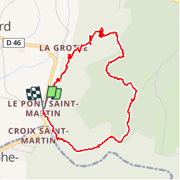
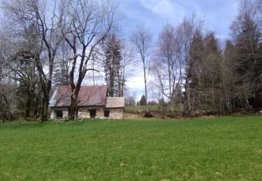
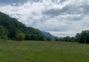
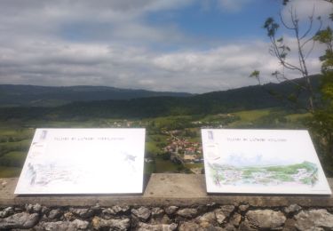
Départ du Pont Saint-Martin,Montée sur le plateau de la Ravoire, on domine les gorges de l'Echaillon. Puis on rejoint le nouveau site Préhistorique  de la Fru qui relie la route Sarde. Et pour finir on retourne au Pont Saint-martin par la route.

Hoogteprofiel

Plaatsbepaling

Land:
France
Regio :
Auvergne-Rhône-Alpes
Departement/Provincie :
Savoie
Gemeente :
Saint-Christophe
Locatie:
Unknown
Vertrek:(Dec)
Vertrek:(UTM)
717607 ; 5036019 (31T) N.

Wandeltochten in de omgeving

Tocht Sneeuwschoenen Saint-Christophe-sur-Guiers - Le Belvédère d'Arpison - Photo
Sneeuwschoenen
patjobou

Sneeuwschoenen

Medium
(1)
Saint-Christophe-sur-Guiers, Auvergne-Rhône-Alpes, Isère, France
11,1 km | 17,4 km-effort
4h 43min
Ja
Tocht Wegfiets Corbel - Entreront  - Photo
Wegfiets
Geneviève Robardey

Wegfiets

Zeer moeilijk
(1)
Corbel, Auvergne-Rhône-Alpes, Savoie, France
34 km | 49 km-effort
2h 53min
Ja
Tocht Stappen Saint-Christophe-sur-Guiers - 38 grand som par sente intermediaire - Photo
Stappen
GUIDE
randodyssée

Stappen

Medium
Saint-Christophe-sur-Guiers, Auvergne-Rhône-Alpes, Isère, France
14,5 km | 28 km-effort
7h 11min
Ja
Tocht Stappen Saint-Christophe - 38 st Christophe sur guiers grottes guiers vif - Photo
Stappen
GUIDE
randodyssée

Stappen

Medium
Saint-Christophe, Auvergne-Rhône-Alpes, Savoie, France
7,3 km | 12,7 km-effort
3h 24min
Ja
Tocht Stappen La Bauche - Ballade vers la Bauche - Photo
Stappen
GUIDE
nadd73

Stappen

Gemakkelijk
La Bauche, Auvergne-Rhône-Alpes, Savoie, France
11,7 km | 23 km-effort
6h 19min
Ja
Tocht Ski randonnée Saint-Christophe-sur-Guiers - Col de mauvernay, de Bovinant, du Frêt et Petit Som - Photo
Ski randonnée
GUIDE
nadd73

Ski randonnée

Medium
Saint-Christophe-sur-Guiers, Auvergne-Rhône-Alpes, Isère, France
12 km | 29 km-effort
6h 2min
Ja
Tocht Stappen Saint-Christophe-sur-Guiers - Petit Som par le Col de la Ruchère - Photo
Stappen
simon.paume

Stappen

Medium
(2)
Saint-Christophe-sur-Guiers, Auvergne-Rhône-Alpes, Isère, France
7,1 km | 15,2 km-effort
3h 5min
Ja
Tocht sport Saint-Christophe - La grotte - Photo
sport
Biquette73

sport

Heel gemakkelijk
Saint-Christophe, Auvergne-Rhône-Alpes, Savoie, France
8,9 km | 14,1 km-effort
Onbekend
Neen
Tocht Trail Saint-Christophe - au dessus de la grotte des échelles  - Photo
Trail
GUIDE
nadd73

Trail

Heel gemakkelijk
Saint-Christophe, Auvergne-Rhône-Alpes, Savoie, France
8 km | 11,8 km-effort
1h 11min
Ja


Sluiten
Mijn abonnementen