Tocht Sneeuwschoenen La Llagonne - Rte Bouillouse Pasquers Reials - Photo

Rte Bouillouse Pasquers Reials

 jpipacific
jpipacific

Gebruiker

© OpenStreetMap contributors
Lengte
Lengte
7 km
Max. hoogte
Max. hoogte
1831 m
Positief hoogteverschil
179 m
Km-Effort
Km-Effort  
9,4 km
Min. hoogte
Min. hoogte
1669 m
Negatief hoogteverschil
181 m
Boucle
Boucle
Ja
Datum van aanmaak :
2016-03-14 00:00:00.0
Laatste wijziging :
2016-03-14 00:00:00.0

(0 Bericht)

Sneeuwschoenen
Sneeuwschoenen
2h49
Moeilijkheid : Heel gemakkelijk

Scan deze QR-code om de tocht te openen in de SityTrail-applicatie

Gratisgps-wandelapplicatie

Logo SityTrail SityTrail

IGN / Geografische instituten

SityTrail uit de App Store downloaden SityTrail uit Google Play downloaden

Logo SityTrail SityTrail World

De wereld gaat voor u open

SityTrail uit de App Store downloaden SityTrail uit Google Play downloaden SityTrail op Huawei AppGallery downloaden

Over ons

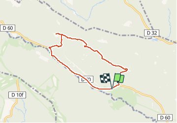
Tocht Sneeuwschoenen van 7 km beschikbaar op Occitanië, Pyrénées-Orientales, La Llagonne. Deze tocht wordt voorgesteld door jpipacific.

Beschrijving

Rando de sous bois sans vues. Le chemin de descente vers la route n'est pas très facile à trouver si il n'y a pas de trace dans la neige.  Bien par mauvais temps ou pour un début de séjour.

Hoogteprofiel

Foto's

Plaatsbepaling

Land:
France
Regio :
Occitanië
Departement/Provincie :
Pyrénées-Orientales
Gemeente :
La Llagonne
Locatie:
Unknown
Vertrek:(Dec)
Vertrek:(UTM)
424095 ; 4709220 (31T) N.

Wandeltochten in de omgeving

Tocht Stappen Font-Romeu-Odeillo-Via - Coll del Pam lac des  Bouillouses - Photo
Stappen
jcmartin

Stappen

Medium
(2)
Font-Romeu-Odeillo-Via, Occitanië, Pyrénées-Orientales, France
13,3 km | 19,3 km-effort
4h 10min
Ja
Tocht Sneeuwschoenen Font-Romeu-Odeillo-Via - pic dels moros - Photo
Sneeuwschoenen
jpipacific

Sneeuwschoenen

Medium
(1)
Font-Romeu-Odeillo-Via, Occitanië, Pyrénées-Orientales, France
12,6 km | 19,4 km-effort
4h 46min
Ja
Tocht Sneeuwschoenen Les Angles - Lac d Aude -Refuge Bernardi les Angles - Photo
Sneeuwschoenen
MarieFrancoise

Sneeuwschoenen

Medium
(1)
Les Angles, Occitanië, Pyrénées-Orientales, France
13,9 km | 19,1 km-effort
5h 44min
Ja
Tocht Stappen Font-Romeu-Odeillo-Via - Font Romeu Egat - Photo
Stappen
crijack

Stappen

Medium
(2)
Font-Romeu-Odeillo-Via, Occitanië, Pyrénées-Orientales, France
2,5 km | 3,4 km-effort
44min
Ja
Tocht Sneeuwschoenen Font-Romeu-Odeillo-Via - Pic dels Moros avec Pierre - Photo
Sneeuwschoenen
jpipacific

Sneeuwschoenen

Medium
(1)
Font-Romeu-Odeillo-Via, Occitanië, Pyrénées-Orientales, France
10,5 km | 15,9 km-effort
4h 4min
Ja
Tocht Stappen Égat - Egat  Puig  Moro - Photo
Stappen
ohelluin

Stappen

Medium
(1)
Égat, Occitanië, Pyrénées-Orientales, France
13,4 km | 19,3 km-effort
4h 51min
Ja
Tocht Stappen Égat - La croix d'Egat - Photo
Stappen
ochamley

Stappen

Gemakkelijk
(1)
Égat, Occitanië, Pyrénées-Orientales, France
7,1 km | 10,4 km-effort
2h 2min
Ja
Tocht Stappen Égat - Le Pic dels Moros - Photo
Stappen
tracegps

Stappen

Moeilijk
(2)
Égat, Occitanië, Pyrénées-Orientales, France
12,1 km | 18,8 km-effort
5h 30min
Ja
Tocht Mountainbike Font-Romeu-Odeillo-Via - Espace VTT FFC Pyrénées Catalanes - Circuit n° 6 - Forêt d'Egat - Photo
Mountainbike
tracegps

Mountainbike

Medium
(2)
Font-Romeu-Odeillo-Via, Occitanië, Pyrénées-Orientales, France
7,6 km | 10,1 km-effort
1h 0min
Ja


Sluiten
Mijn abonnementen