![](/images/other/stat-length.png)
![Tocht Noords wandelen Ablain-Saint-Nazaire - dore musis ablain-carency - Photo](https://media.geolcdn.com/t/1900/400/ext.pjpeg?maxdim=2&url=https%3A%2F%2Fstatic1.geolcdn.com%2Fsiteimages%2Fupload%2Ffiles%2F1545311037marcheuse_200dpi.jpg)
dore musis ablain-carency
dehemjacques
Gebruiker
![Lengte](/images/other/stat-length.png)
Lengte
11,9 km
![Max. hoogte](https://static1.geolcdn.com/siteimages/upload/files/1508320355ic_sort_altitude_max_24dp.png)
Max. hoogte
137 m
![Positief hoogteverschil](https://static1.geolcdn.com/siteimages/upload/files/1508320355ic_sort_den_pos_24dp.png)
Positief hoogteverschil
143 m
![Km-Effort](/images/other/stat-length.png)
Km-Effort
13,9 km
![Min. hoogte](https://static1.geolcdn.com/siteimages/upload/files/1508320355ic_sort_altitude_min_24dp.png)
Min. hoogte
75 m
![Negatief hoogteverschil](https://static1.geolcdn.com/siteimages/upload/files/1508320355ic_sort_den_neg_24dp.png)
Negatief hoogteverschil
143 m
![Boucle](https://static1.geolcdn.com/siteimages/upload/files/16400158638029165_repeat_loop_refresh_sync_direction_icon.png)
Boucle
Ja
Datum van aanmaak :
2016-03-09 00:00:00.0
Laatste wijziging :
2016-03-09 00:00:00.0
![Noords wandelen](https://static1.geolcdn.com/sitytour/trail-icons/102.png)
2h05
Moeilijkheid : Medium
![Scan deze QR-code om de tocht te openen in de SityTrail-applicatie](https://capi.geolives.com/qq0zvz2zws4bq2lad0pu/sitytour/trails/528357/qr.png?size=200)
Gratisgps-wandelapplicatie
Over ons
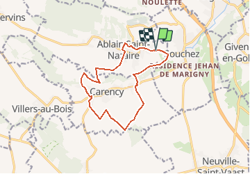
Tocht Noords wandelen van 11,9 km beschikbaar op Hauts-de-France, Pas-de-Calais, Ablain-Saint-Nazaire. Deze tocht wordt voorgesteld door dehemjacques.
Beschrijving
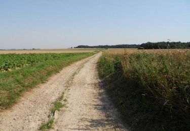
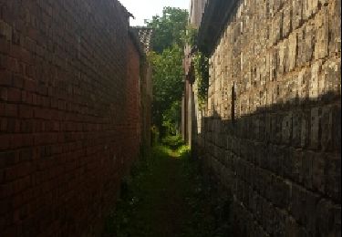
départ de la ferme de la molaine à Ablain saint Nazaire puis Carency par le GR 127, retour sur Ablain le long du st nazaire
Plaatsbepaling
Land:
France
Regio :
Hauts-de-France
Departement/Provincie :
Pas-de-Calais
Gemeente :
Ablain-Saint-Nazaire
Locatie:
Unknown
Vertrek:(Dec)
Vertrek:(UTM)
480678 ; 5582248 (31U) N.
Opmerkingen
Wandeltochten in de omgeving
![Tocht Stappen Mont-Saint-Éloi - Autour du Mont-Saint-Éloi - Photo](https://media.geolcdn.com/t/375/260/ext.jpg?maxdim=2&url=https%3A%2F%2Fservices.sitytrail.com%2FGeolivesWS%2FDownloadMedia.ashx%3FTrailID%3D215199%26Media%3D15804_6.jpg)
![Stappen Stappen](https://static1.geolcdn.com/sitytour/trail-icons/101.png)
Autour du Mont-Saint-Éloi
Stappen
Moeilijk
(3)
Mont-Saint-Éloi,
Hauts-de-France,
Pas-de-Calais,
France
![](/images/other/stat-length.png)
14,3 km | 16,7 km-effort
3h 34min
![](https://static1.geolcdn.com/siteimages/upload/files/16400158638029165_repeat_loop_refresh_sync_direction_icon.png)
Ja
![Tocht Stappen Liévin - 50 km Lievin en nocturne - Photo](https://media.geolcdn.com/t/375/260/ext.jpg?maxdim=2&url=https%3A%2F%2Fstatic1.geolcdn.com%2Fsiteimages%2Fupload%2Ffiles%2F1553511878bg_sport_marche.png)
![Stappen Stappen](https://static1.geolcdn.com/sitytour/trail-icons/101.png)
50 km Lievin en nocturne
Stappen
Zeer moeilijk
(1)
Liévin,
Hauts-de-France,
Pas-de-Calais,
France
![](/images/other/stat-length.png)
52 km | 61 km-effort
9h 0min
![](https://static1.geolcdn.com/siteimages/upload/files/16400158638029165_repeat_loop_refresh_sync_direction_icon.png)
Ja
![Tocht Noords wandelen Mont-Saint-Éloi - Les trois abbayes - Photo](https://media.geolcdn.com/t/375/260/a20b48c3-4fa6-4de3-bf52-85a257498803.jpeg&format=jpg&maxdim=2)
![Noords wandelen Noords wandelen](https://static1.geolcdn.com/sitytour/trail-icons/102.png)
Les trois abbayes
Noords wandelen
Gemakkelijk
Mont-Saint-Éloi,
Hauts-de-France,
Pas-de-Calais,
France
![](/images/other/stat-length.png)
16,2 km | 18,9 km-effort
3h 24min
![](https://static1.geolcdn.com/siteimages/upload/files/16400158638029165_repeat_loop_refresh_sync_direction_icon.png)
Ja
![Tocht Stappen Angres - randonnée pinchonvalles - Photo](https://media.geolcdn.com/t/375/260/b2891722-43d7-4acf-b8f9-14f5909069c3.jpg&format=jpg&maxdim=2)
![Stappen Stappen](https://static1.geolcdn.com/sitytour/trail-icons/101.png)
randonnée pinchonvalles
Stappen
Zeer moeilijk
Angres,
Hauts-de-France,
Pas-de-Calais,
France
![](/images/other/stat-length.png)
27 km | 0 m-effort
3h 24min
![](https://static1.geolcdn.com/siteimages/upload/files/16400158638029165_repeat_loop_refresh_sync_direction_icon.png)
Neen
![Tocht Andere activiteiten Liévin - boucle Liévin - Photo](https://media.geolcdn.com/t/375/260/ext.jpg?maxdim=2&url=https%3A%2F%2Fservices.sitytrail.com%2FGeolivesWS%2FDownloadMedia.ashx%3FTrailID%3D956017%26Media%3D20180429102202.jpg)
![Andere activiteiten Andere activiteiten](https://static1.geolcdn.com/sitytour/trail-icons/900.png)
boucle Liévin
Andere activiteiten
Heel gemakkelijk
Liévin,
Hauts-de-France,
Pas-de-Calais,
France
![](/images/other/stat-length.png)
11 km | 12,3 km-effort
2h 2min
![](https://static1.geolcdn.com/siteimages/upload/files/16400158638029165_repeat_loop_refresh_sync_direction_icon.png)
Ja
![Tocht Andere activiteiten Liévin - boucle Liévin - Photo](https://media.geolcdn.com/t/375/260/ext.jpg?maxdim=2&url=https%3A%2F%2Fservices.sitytrail.com%2FGeolivesWS%2FDownloadMedia.ashx%3FTrailID%3D953687%26Media%3D20180429102202.jpg)
![Andere activiteiten Andere activiteiten](https://static1.geolcdn.com/sitytour/trail-icons/900.png)
boucle Liévin
Andere activiteiten
Heel gemakkelijk
Liévin,
Hauts-de-France,
Pas-de-Calais,
France
![](/images/other/stat-length.png)
11 km | 12,3 km-effort
2h 2min
![](https://static1.geolcdn.com/siteimages/upload/files/16400158638029165_repeat_loop_refresh_sync_direction_icon.png)
Ja
![Tocht Lopen Aix-Noulette - aix noulette sity guide 25,3 km D530+ - Photo](https://media.geolcdn.com/t/375/260/ext.jpg?maxdim=2&url=https%3A%2F%2Fservices.sitytrail.com%2FGeolivesWS%2FDownloadMedia.ashx%3FTrailID%3D229340%26Media%3Dfix__20131027100347.jpg)
![Lopen Lopen](https://static1.geolcdn.com/sitytour/trail-icons/103.png)
aix noulette sity guide 25,3 km D530+
Lopen
Medium
Aix-Noulette,
Hauts-de-France,
Pas-de-Calais,
France
![](/images/other/stat-length.png)
23 km | 30 km-effort
2h 45min
![](https://static1.geolcdn.com/siteimages/upload/files/16400158638029165_repeat_loop_refresh_sync_direction_icon.png)
Ja
![Tocht Stappen Neuville-Saint-Vaast - tour Neuville p1 - Photo](https://media.geolcdn.com/t/375/260/ext.jpg?maxdim=2&url=https%3A%2F%2Fservices.sitytrail.com%2FGeolivesWS%2FDownloadMedia.ashx%3FTrailID%3D200820%26Media%3Dfix__20130627100400.jpg)
![Stappen Stappen](https://static1.geolcdn.com/sitytour/trail-icons/101.png)
tour Neuville p1
Stappen
Gemakkelijk
Neuville-Saint-Vaast,
Hauts-de-France,
Pas-de-Calais,
France
![](/images/other/stat-length.png)
4 km | 4,5 km-effort
1h 1min
![](https://static1.geolcdn.com/siteimages/upload/files/16400158638029165_repeat_loop_refresh_sync_direction_icon.png)
Neen
![Tocht Stappen Souchez - Souchez-Noulette-Lorette-Ablain - Photo](https://media.geolcdn.com/t/375/260/ext.jpg?maxdim=2&url=https%3A%2F%2Fservices.sitytrail.com%2FGeolivesWS%2FDownloadMedia.ashx%3FTrailID%3D173056%26Media%3D14580_6.jpg)
![Stappen Stappen](https://static1.geolcdn.com/sitytour/trail-icons/101.png)
Souchez-Noulette-Lorette-Ablain
Stappen
Gemakkelijk
Souchez,
Hauts-de-France,
Pas-de-Calais,
France
![](/images/other/stat-length.png)
6,7 km | 8,4 km-effort
1h 45min
![](https://static1.geolcdn.com/siteimages/upload/files/16400158638029165_repeat_loop_refresh_sync_direction_icon.png)
Ja