![](/images/other/stat-length.png)
![Tocht Stappen Palavas-les-Flots - De Palavas à Maguelone - Photo](https://media.geolcdn.com/t/1900/400/ext.pjpeg?maxdim=2&url=https%3A%2F%2Fstatic1.geolcdn.com%2Fsiteimages%2Fupload%2Ffiles%2F1553511878bg_sport_marche.png)
De Palavas à Maguelone
randotines
Gebruiker GUIDE
![Lengte](/images/other/stat-length.png)
Lengte
11,8 km
![Max. hoogte](https://static1.geolcdn.com/siteimages/upload/files/1508320355ic_sort_altitude_max_24dp.png)
Max. hoogte
13 m
![Positief hoogteverschil](https://static1.geolcdn.com/siteimages/upload/files/1508320355ic_sort_den_pos_24dp.png)
Positief hoogteverschil
49 m
![Km-Effort](/images/other/stat-length.png)
Km-Effort
12,5 km
![Min. hoogte](https://static1.geolcdn.com/siteimages/upload/files/1508320355ic_sort_altitude_min_24dp.png)
Min. hoogte
-2 m
![Negatief hoogteverschil](https://static1.geolcdn.com/siteimages/upload/files/1508320355ic_sort_den_neg_24dp.png)
Negatief hoogteverschil
49 m
![Boucle](https://static1.geolcdn.com/siteimages/upload/files/16400158638029165_repeat_loop_refresh_sync_direction_icon.png)
Boucle
Ja
Datum van aanmaak :
2016-01-10 00:00:00.0
Laatste wijziging :
2016-01-10 00:00:00.0
![Stappen](https://static1.geolcdn.com/sitytour/trail-icons/101.png)
2h47
Moeilijkheid : Gemakkelijk
![Scan deze QR-code om de tocht te openen in de SityTrail-applicatie](https://capi.geolives.com/qq0zvz2zws4bq2lad0pu/sitytour/trails/511243/qr.png?size=200)
Gratisgps-wandelapplicatie
Over ons
Tocht Stappen van 11,8 km beschikbaar op Occitanië, Hérault, Palavas-les-Flots. Deze tocht wordt voorgesteld door randotines.
Beschrijving
Départ du parking sous la voie rapide Montpellier - Palavas au lieu dit " les quatre canaux " ( quelques places ) mais on peut aussi se garer aux Arènes, c'est plus facile....
Plaatsbepaling
Land:
France
Regio :
Occitanië
Departement/Provincie :
Hérault
Gemeente :
Palavas-les-Flots
Locatie:
Unknown
Vertrek:(Dec)
Vertrek:(UTM)
574118 ; 4820477 (31T) N.
Opmerkingen
Wandeltochten in de omgeving
![Tocht Hybride fiets Villeneuve-lès-Maguelone - Via Rhona Palavas/ Frontignan - Photo](https://media.geolcdn.com/t/375/260/ext.jpg?maxdim=2&url=https%3A%2F%2Fmedia.geolcdn.com%2Ff%2F8141a6e5-ab57-4fc0-b394-76b65ec69abf.jpg)
![Hybride fiets Hybride fiets](https://static1.geolcdn.com/sitytour/trail-icons/203.png)
Via Rhona Palavas/ Frontignan
Hybride fiets
Medium
Villeneuve-lès-Maguelone,
Occitanië,
Hérault,
France
![](/images/other/stat-length.png)
55 km | 59 km-effort
4h 25min
![](https://static1.geolcdn.com/siteimages/upload/files/16400158638029165_repeat_loop_refresh_sync_direction_icon.png)
Ja
![Tocht Stappen Pérols - Perols - Photo](https://media.geolcdn.com/t/375/260/ext.jpg?maxdim=2&url=https%3A%2F%2Fstatic1.geolcdn.com%2Fsiteimages%2Fupload%2Ffiles%2F1553511878bg_sport_marche.png)
![Stappen Stappen](https://static1.geolcdn.com/sitytour/trail-icons/101.png)
Perols
Stappen
Heel gemakkelijk
(1)
Pérols,
Occitanië,
Hérault,
France
![](/images/other/stat-length.png)
9,3 km | 9,8 km-effort
2h 48min
![](https://static1.geolcdn.com/siteimages/upload/files/16400158638029165_repeat_loop_refresh_sync_direction_icon.png)
Ja
![Tocht Stappen Villeneuve-lès-Maguelone - cathédrale de Maguelone - Photo](https://media.geolcdn.com/t/375/260/ext.jpg?maxdim=2&url=https%3A%2F%2Fmedia.geolcdn.com%2Ff%2F2dde4578-4db3-4940-9c4c-39e3d3cbcdc0.jpg)
![Stappen Stappen](https://static1.geolcdn.com/sitytour/trail-icons/101.png)
cathédrale de Maguelone
Stappen
Heel gemakkelijk
Villeneuve-lès-Maguelone,
Occitanië,
Hérault,
France
![](/images/other/stat-length.png)
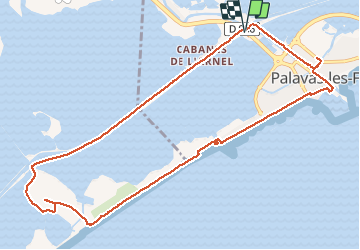
3,9 km | 4,3 km-effort
1h 31min
![](https://static1.geolcdn.com/siteimages/upload/files/16400158638029165_repeat_loop_refresh_sync_direction_icon.png)
Ja
![Tocht Te voet Lattes - Sentier des tamaris - Photo](https://media.geolcdn.com/t/375/260/ext.jpg?maxdim=2&url=https%3A%2F%2Fmedia.geolcdn.com%2Ff%2F8b457c06-ac91-47bf-8ded-e7e0aa23b32b.jpeg)
![Te voet Te voet](https://static1.geolcdn.com/sitytour/trail-icons/100.png)
Sentier des tamaris
Te voet
Gemakkelijk
Lattes,
Occitanië,
Hérault,
France
![](/images/other/stat-length.png)
3,1 km | 3,1 km-effort
42min
![](https://static1.geolcdn.com/siteimages/upload/files/16400158638029165_repeat_loop_refresh_sync_direction_icon.png)
Neen
![Tocht Stappen Palavas-les-Flots - Palavas-les-flots à Cathédrale St Pierre Maguelone et retour - Photo](https://media.geolcdn.com/t/375/260/ext.jpg?maxdim=2&url=https%3A%2F%2Fmedia.geolcdn.com%2Ff%2Ff07b9995-09f7-433d-af0b-3b97c66d9c56.JPG)
![Stappen Stappen](https://static1.geolcdn.com/sitytour/trail-icons/101.png)
Palavas-les-flots à Cathédrale St Pierre Maguelone et retour
Stappen
Heel gemakkelijk
Palavas-les-Flots,
Occitanië,
Hérault,
France
![](/images/other/stat-length.png)
7,4 km | 7,8 km-effort
1h 40min
![](https://static1.geolcdn.com/siteimages/upload/files/16400158638029165_repeat_loop_refresh_sync_direction_icon.png)
Ja
![Tocht Stappen Lattes - tour étang du Méjean Lattes - Photo](https://media.geolcdn.com/t/375/260/ext.jpg?maxdim=2&url=https%3A%2F%2Fmedia.geolcdn.com%2Ff%2F0a0b365e-4ca7-4652-9060-635f4197cb0d.jpg)
![Stappen Stappen](https://static1.geolcdn.com/sitytour/trail-icons/101.png)
tour étang du Méjean Lattes
Stappen
Heel gemakkelijk
Lattes,
Occitanië,
Hérault,
France
![](/images/other/stat-length.png)
6,3 km | 6,6 km-effort
1h 12min
![](https://static1.geolcdn.com/siteimages/upload/files/16400158638029165_repeat_loop_refresh_sync_direction_icon.png)
Ja
![Tocht Hybride fiets Palavas-les-Flots - Palavas vélo - Photo](https://media.geolcdn.com/t/375/260/ext.jpg?maxdim=2&url=https%3A%2F%2Fstatic1.geolcdn.com%2Fsiteimages%2Fupload%2Ffiles%2F1524743154velo.jpg)
![Hybride fiets Hybride fiets](https://static1.geolcdn.com/sitytour/trail-icons/203.png)
Palavas vélo
Hybride fiets
Heel gemakkelijk
(1)
Palavas-les-Flots,
Occitanië,
Hérault,
France
![](/images/other/stat-length.png)
19,6 km | 21 km-effort
Onbekend
![](https://static1.geolcdn.com/siteimages/upload/files/16400158638029165_repeat_loop_refresh_sync_direction_icon.png)
Ja
![Tocht Stappen Lattes - Etang du mejean - Photo](https://media.geolcdn.com/t/375/260/ext.jpg?maxdim=2&url=https%3A%2F%2Fservices.sitytrail.com%2FGeolivesWS%2FDownloadMedia.ashx%3FTrailID%3D946276%26Media%3Dfix__20180418162506.jpg)
![Stappen Stappen](https://static1.geolcdn.com/sitytour/trail-icons/101.png)
Etang du mejean
Stappen
Gemakkelijk
Lattes,
Occitanië,
Hérault,
France
![](/images/other/stat-length.png)
11,2 km | 11,6 km-effort
2h 36min
![](https://static1.geolcdn.com/siteimages/upload/files/16400158638029165_repeat_loop_refresh_sync_direction_icon.png)
Ja
![Tocht Stappen Villeneuve-lès-Maguelone - salins Villeneuve les maguelone - Photo](https://media.geolcdn.com/t/375/260/ext.jpg?maxdim=2&url=https%3A%2F%2Fstatic1.geolcdn.com%2Fsiteimages%2Fupload%2Ffiles%2F1553511878bg_sport_marche.png)
![Stappen Stappen](https://static1.geolcdn.com/sitytour/trail-icons/101.png)
salins Villeneuve les maguelone
Stappen
Medium
(1)
Villeneuve-lès-Maguelone,
Occitanië,
Hérault,
France
![](/images/other/stat-length.png)
14,4 km | 15,4 km-effort
3h 26min
![](https://static1.geolcdn.com/siteimages/upload/files/16400158638029165_repeat_loop_refresh_sync_direction_icon.png)
Ja