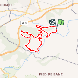
![](/images/other/stat-length.png)
![Tocht Stappen Les Arcs-sur-Argens - Les Arcs - les Apiés 2 reco - Photo](https://media.geolcdn.com/t/1900/400/ext.pjpeg?maxdim=2&url=https%3A%2F%2Fstatic1.geolcdn.com%2Fsiteimages%2Fupload%2Ffiles%2F1553511878bg_sport_marche.png)
Les Arcs - les Apiés 2 reco
Sugg
Gebruiker
![Lengte](/images/other/stat-length.png)
![Max. hoogte](https://static1.geolcdn.com/siteimages/upload/files/1508320355ic_sort_altitude_max_24dp.png)
![Positief hoogteverschil](https://static1.geolcdn.com/siteimages/upload/files/1508320355ic_sort_den_pos_24dp.png)
![Km-Effort](/images/other/stat-length.png)
![Min. hoogte](https://static1.geolcdn.com/siteimages/upload/files/1508320355ic_sort_altitude_min_24dp.png)
![Negatief hoogteverschil](https://static1.geolcdn.com/siteimages/upload/files/1508320355ic_sort_den_neg_24dp.png)
![Boucle](https://static1.geolcdn.com/siteimages/upload/files/16400158638029165_repeat_loop_refresh_sync_direction_icon.png)
![Stappen](https://static1.geolcdn.com/sitytour/trail-icons/101.png)
4h59
Moeilijkheid : Medium
![Scan deze QR-code om de tocht te openen in de SityTrail-applicatie](https://capi.geolives.com/qq0zvz2zws4bq2lad0pu/sitytour/trails/502965/qr.png?size=200)
Gratisgps-wandelapplicatie
Over ons
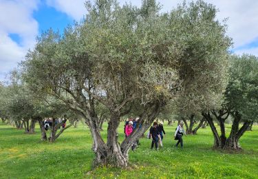
Tocht Stappen van 17,1 km beschikbaar op Provence-Alpes-Côte d'Azur, Var, Les Arcs-sur-Argens. Deze tocht wordt voorgesteld door Sugg.
Beschrijving
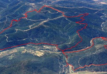
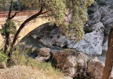
14-12-15, reco avec Pierre de la rando du 16-12-15.
La boucle de Caillandres est intéressante ainsi que la descente sur l'Aille sous l'Apié de Raybaud qui est d'ailleurs aménagée.
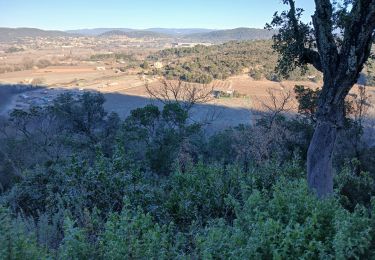
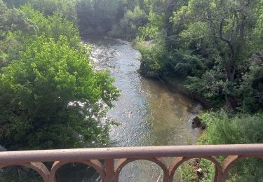
Le retour au pont de l'Aille est super sympa.
Le groupe appréciera certainement.
Plaatsbepaling
Opmerkingen
Wandeltochten in de omgeving
![Tocht Stappen Les Arcs-sur-Argens - Trace_Les_Arcs - Photo](https://media.geolcdn.com/t/375/260/da020f46-e58f-416a-9a61-5f98a0302baf.jpg&format=jpg&maxdim=2)
![Stappen Stappen](https://static1.geolcdn.com/sitytour/trail-icons/101.png)
Stappen
![](/images/other/stat-length.png)
![](https://static1.geolcdn.com/siteimages/upload/files/16400158638029165_repeat_loop_refresh_sync_direction_icon.png)
![Tocht Stappen Les Arcs-sur-Argens - LES ARC SUR ARGENS-Fond du Loup-LA bergerie -DRI - Photo](https://media.geolcdn.com/t/375/260/ext.jpg?maxdim=2&url=https%3A%2F%2Fstatic1.geolcdn.com%2Fsiteimages%2Fupload%2Ffiles%2F1553511878bg_sport_marche.png)
![Stappen Stappen](https://static1.geolcdn.com/sitytour/trail-icons/101.png)
Stappen
![](/images/other/stat-length.png)
![](https://static1.geolcdn.com/siteimages/upload/files/16400158638029165_repeat_loop_refresh_sync_direction_icon.png)
![Tocht Stappen Vidauban - vidauban l'Aille - Photo](https://media.geolcdn.com/t/375/260/ext.jpg?maxdim=2&url=https%3A%2F%2Fstatic1.geolcdn.com%2Fsiteimages%2Fupload%2Ffiles%2F1553511878bg_sport_marche.png)
![Stappen Stappen](https://static1.geolcdn.com/sitytour/trail-icons/101.png)
Stappen
![](/images/other/stat-length.png)
![](https://static1.geolcdn.com/siteimages/upload/files/16400158638029165_repeat_loop_refresh_sync_direction_icon.png)
![Tocht Stappen Les Arcs-sur-Argens - La colline de Cabredor les Arcs sur Argens, 17-01-2025 - Photo](https://media.geolcdn.com/t/375/260/3f2f9c21-31ed-48da-929f-286bae1564fc.jpg&format=jpg&maxdim=2)
![Stappen Stappen](https://static1.geolcdn.com/sitytour/trail-icons/101.png)
Stappen
![](/images/other/stat-length.png)
![](https://static1.geolcdn.com/siteimages/upload/files/16400158638029165_repeat_loop_refresh_sync_direction_icon.png)
![Tocht Stappen Le Muy - Rocher de Roquebrune, Les 2 frères - Photo](https://media.geolcdn.com/t/375/260/4c3abf35-bd0e-4562-9d28-88f605def60c.jpg&format=jpg&maxdim=2)
![Stappen Stappen](https://static1.geolcdn.com/sitytour/trail-icons/101.png)
Stappen
![](/images/other/stat-length.png)
![](https://static1.geolcdn.com/siteimages/upload/files/16400158638029165_repeat_loop_refresh_sync_direction_icon.png)
![Tocht Stappen Les Arcs-sur-Argens - Les Arcs Menhirs et Dolmen - Photo](https://media.geolcdn.com/t/375/260/5cd1c0e7-b5dd-4488-ac15-1c89d37aafb6.jpg&format=jpg&maxdim=2)
![Stappen Stappen](https://static1.geolcdn.com/sitytour/trail-icons/101.png)
Stappen
![](/images/other/stat-length.png)
![](https://static1.geolcdn.com/siteimages/upload/files/16400158638029165_repeat_loop_refresh_sync_direction_icon.png)
![Tocht Stappen Les Arcs-sur-Argens - Les Arcs Menhirs et Dolmen - Photo](https://media.geolcdn.com/t/375/260/file:///storage/5427-3A6F/Android/data/com.geolives.apps.sitytrail.beta/files/ressources/captured_photos/20180713111205.jpg&format=jpg&maxdim=2)
![Stappen Stappen](https://static1.geolcdn.com/sitytour/trail-icons/101.png)
Stappen
![](/images/other/stat-length.png)
![](https://static1.geolcdn.com/siteimages/upload/files/16400158638029165_repeat_loop_refresh_sync_direction_icon.png)
![Tocht Stappen Les Arcs-sur-Argens - LES ARCS - LE MUY - LA MOTTE - SAINTE ROSELINE ET VALBOURGES - Photo](https://media.geolcdn.com/t/375/260/24a596bd-8063-44a1-bfa4-688d03d8c334.jpg&format=jpg&maxdim=2)
![Stappen Stappen](https://static1.geolcdn.com/sitytour/trail-icons/101.png)
Stappen
![](/images/other/stat-length.png)
![](https://static1.geolcdn.com/siteimages/upload/files/16400158638029165_repeat_loop_refresh_sync_direction_icon.png)
![Tocht Stappen Les Arcs-sur-Argens - sommet des Terriers, les Arcs sur Argens, 15-11-23 - Photo](https://media.geolcdn.com/t/375/260/6cb55497-4df5-448d-b641-e902de3da9ba.jpg&format=jpg&maxdim=2)
![Stappen Stappen](https://static1.geolcdn.com/sitytour/trail-icons/101.png)
Stappen
![](/images/other/stat-length.png)
![](https://static1.geolcdn.com/siteimages/upload/files/16400158638029165_repeat_loop_refresh_sync_direction_icon.png)