![](/images/other/stat-length.png)
![Tocht Stappen Les Arcs-sur-Argens - Les Arcs-Sommet des Terriers 0 - Photo](https://media.geolcdn.com/t/1900/400/ext.pjpeg?maxdim=2&url=https%3A%2F%2Fstatic1.geolcdn.com%2Fsiteimages%2Fupload%2Ffiles%2F1553511878bg_sport_marche.png)
Les Arcs-Sommet des Terriers 0
Sugg
Gebruiker
![Lengte](/images/other/stat-length.png)
![Max. hoogte](https://static1.geolcdn.com/siteimages/upload/files/1508320355ic_sort_altitude_max_24dp.png)
![Positief hoogteverschil](https://static1.geolcdn.com/siteimages/upload/files/1508320355ic_sort_den_pos_24dp.png)
![Km-Effort](/images/other/stat-length.png)
![Min. hoogte](https://static1.geolcdn.com/siteimages/upload/files/1508320355ic_sort_altitude_min_24dp.png)
![Negatief hoogteverschil](https://static1.geolcdn.com/siteimages/upload/files/1508320355ic_sort_den_neg_24dp.png)
![Boucle](https://static1.geolcdn.com/siteimages/upload/files/16400158638029165_repeat_loop_refresh_sync_direction_icon.png)
![Stappen](https://static1.geolcdn.com/sitytour/trail-icons/101.png)
5h36
Moeilijkheid : Moeilijk
![Scan deze QR-code om de tocht te openen in de SityTrail-applicatie](https://capi.geolives.com/qq0zvz2zws4bq2lad0pu/sitytour/trails/499375/qr.png?size=200)
Gratisgps-wandelapplicatie
Over ons
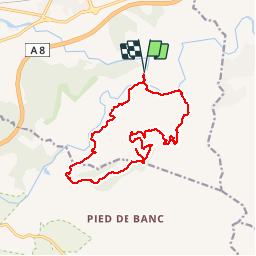
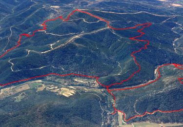
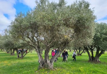
Tocht Stappen van 17,2 km beschikbaar op Provence-Alpes-Côte d'Azur, Var, Les Arcs-sur-Argens. Deze tocht wordt voorgesteld door Sugg.
Beschrijving
Rando réelle du 02-12-15 avec RF.
Quelques difficultés, en particulier au Sud-Ouest, la remontée en 123 ( citerne ) est particulièrement raide ( pour des seniors ).
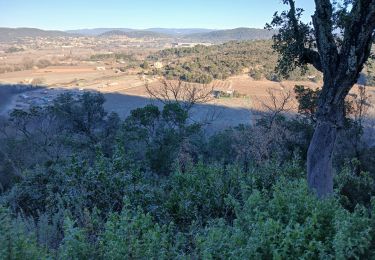
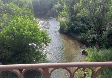
Très beau et riche parcours, voir ici : http://www.mairie-les-arcs-sur-argens.fr/associations-culture/tourisme/patrimoine.html
Ce parcours sera a nouveau effectué mais dans une version plus simple.
Plaatsbepaling
Opmerkingen
Wandeltochten in de omgeving
![Tocht Stappen Les Arcs-sur-Argens - Trace_Les_Arcs - Photo](https://media.geolcdn.com/t/375/260/da020f46-e58f-416a-9a61-5f98a0302baf.jpg&format=jpg&maxdim=2)
![Stappen Stappen](https://static1.geolcdn.com/sitytour/trail-icons/101.png)
Stappen
![](/images/other/stat-length.png)
![](https://static1.geolcdn.com/siteimages/upload/files/16400158638029165_repeat_loop_refresh_sync_direction_icon.png)
![Tocht Stappen Les Arcs-sur-Argens - LES ARC SUR ARGENS-Fond du Loup-LA bergerie -DRI - Photo](https://media.geolcdn.com/t/375/260/ext.jpg?maxdim=2&url=https%3A%2F%2Fstatic1.geolcdn.com%2Fsiteimages%2Fupload%2Ffiles%2F1553511878bg_sport_marche.png)
![Stappen Stappen](https://static1.geolcdn.com/sitytour/trail-icons/101.png)
Stappen
![](/images/other/stat-length.png)
![](https://static1.geolcdn.com/siteimages/upload/files/16400158638029165_repeat_loop_refresh_sync_direction_icon.png)
![Tocht Stappen Vidauban - vidauban l'Aille - Photo](https://media.geolcdn.com/t/375/260/ext.jpg?maxdim=2&url=https%3A%2F%2Fstatic1.geolcdn.com%2Fsiteimages%2Fupload%2Ffiles%2F1553511878bg_sport_marche.png)
![Stappen Stappen](https://static1.geolcdn.com/sitytour/trail-icons/101.png)
Stappen
![](/images/other/stat-length.png)
![](https://static1.geolcdn.com/siteimages/upload/files/16400158638029165_repeat_loop_refresh_sync_direction_icon.png)
![Tocht Stappen Les Arcs-sur-Argens - La colline de Cabredor les Arcs sur Argens, 17-01-2025 - Photo](https://media.geolcdn.com/t/375/260/3f2f9c21-31ed-48da-929f-286bae1564fc.jpg&format=jpg&maxdim=2)
![Stappen Stappen](https://static1.geolcdn.com/sitytour/trail-icons/101.png)
Stappen
![](/images/other/stat-length.png)
![](https://static1.geolcdn.com/siteimages/upload/files/16400158638029165_repeat_loop_refresh_sync_direction_icon.png)
![Tocht Stappen Le Muy - Rocher de Roquebrune, Les 2 frères - Photo](https://media.geolcdn.com/t/375/260/4c3abf35-bd0e-4562-9d28-88f605def60c.jpg&format=jpg&maxdim=2)
![Stappen Stappen](https://static1.geolcdn.com/sitytour/trail-icons/101.png)
Stappen
![](/images/other/stat-length.png)
![](https://static1.geolcdn.com/siteimages/upload/files/16400158638029165_repeat_loop_refresh_sync_direction_icon.png)
![Tocht Stappen Les Arcs-sur-Argens - Les Arcs Menhirs et Dolmen - Photo](https://media.geolcdn.com/t/375/260/5cd1c0e7-b5dd-4488-ac15-1c89d37aafb6.jpg&format=jpg&maxdim=2)
![Stappen Stappen](https://static1.geolcdn.com/sitytour/trail-icons/101.png)
Stappen
![](/images/other/stat-length.png)
![](https://static1.geolcdn.com/siteimages/upload/files/16400158638029165_repeat_loop_refresh_sync_direction_icon.png)
![Tocht Stappen Les Arcs-sur-Argens - Les Arcs Menhirs et Dolmen - Photo](https://media.geolcdn.com/t/375/260/file:///storage/5427-3A6F/Android/data/com.geolives.apps.sitytrail.beta/files/ressources/captured_photos/20180713111205.jpg&format=jpg&maxdim=2)
![Stappen Stappen](https://static1.geolcdn.com/sitytour/trail-icons/101.png)
Stappen
![](/images/other/stat-length.png)
![](https://static1.geolcdn.com/siteimages/upload/files/16400158638029165_repeat_loop_refresh_sync_direction_icon.png)
![Tocht Stappen Les Arcs-sur-Argens - LES ARCS - LE MUY - LA MOTTE - SAINTE ROSELINE ET VALBOURGES - Photo](https://media.geolcdn.com/t/375/260/24a596bd-8063-44a1-bfa4-688d03d8c334.jpg&format=jpg&maxdim=2)
![Stappen Stappen](https://static1.geolcdn.com/sitytour/trail-icons/101.png)
Stappen
![](/images/other/stat-length.png)
![](https://static1.geolcdn.com/siteimages/upload/files/16400158638029165_repeat_loop_refresh_sync_direction_icon.png)
![Tocht Stappen Les Arcs-sur-Argens - sommet des Terriers, les Arcs sur Argens, 15-11-23 - Photo](https://media.geolcdn.com/t/375/260/6cb55497-4df5-448d-b641-e902de3da9ba.jpg&format=jpg&maxdim=2)
![Stappen Stappen](https://static1.geolcdn.com/sitytour/trail-icons/101.png)
Stappen
![](/images/other/stat-length.png)
![](https://static1.geolcdn.com/siteimages/upload/files/16400158638029165_repeat_loop_refresh_sync_direction_icon.png)