![](/images/other/stat-length.png)
![Tocht Stappen Hondouville - Hondouville-Noyon-Canappeville par Arboretum (Circuit2)_11.5Km - Photo](https://media.geolcdn.com/t/1900/400/ext.pjpeg?maxdim=2&url=https%3A%2F%2Fstatic1.geolcdn.com%2Fsiteimages%2Fupload%2Ffiles%2F1553511878bg_sport_marche.png)
Hondouville-Noyon-Canappeville par Arboretum (Circuit2)_11.5Km
douneto
Gebruiker
![Lengte](/images/other/stat-length.png)
Lengte
11,4 km
![Max. hoogte](https://static1.geolcdn.com/siteimages/upload/files/1508320355ic_sort_altitude_max_24dp.png)
Max. hoogte
153 m
![Positief hoogteverschil](https://static1.geolcdn.com/siteimages/upload/files/1508320355ic_sort_den_pos_24dp.png)
Positief hoogteverschil
212 m
![Km-Effort](/images/other/stat-length.png)
Km-Effort
14,2 km
![Min. hoogte](https://static1.geolcdn.com/siteimages/upload/files/1508320355ic_sort_altitude_min_24dp.png)
Min. hoogte
35 m
![Negatief hoogteverschil](https://static1.geolcdn.com/siteimages/upload/files/1508320355ic_sort_den_neg_24dp.png)
Negatief hoogteverschil
212 m
![Boucle](https://static1.geolcdn.com/siteimages/upload/files/16400158638029165_repeat_loop_refresh_sync_direction_icon.png)
Boucle
Ja
Datum van aanmaak :
2019-04-30 14:32:48.868
Laatste wijziging :
2019-04-30 14:32:48.902
![Stappen](https://static1.geolcdn.com/sitytour/trail-icons/101.png)
3h00
Moeilijkheid : Gemakkelijk
![Scan deze QR-code om de tocht te openen in de SityTrail-applicatie](https://capi.geolives.com/qq0zvz2zws4bq2lad0pu/sitytour/trails/492835/qr.png?size=200)
Gratisgps-wandelapplicatie
Over ons
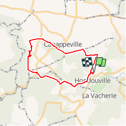
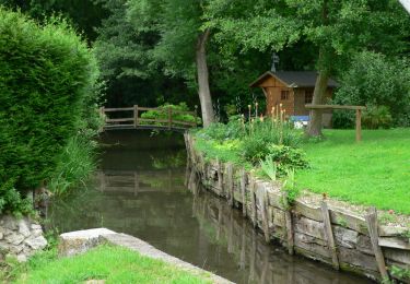
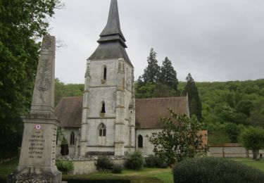
Tocht Stappen van 11,4 km beschikbaar op Normandië, Eure, Hondouville. Deze tocht wordt voorgesteld door douneto.
Beschrijving
Rando Novembre 2015
Départ du parking du cimetière Hondouville.
Attention en période de chasse fermeture possible de certains passages en forêt.
Plaatsbepaling
Land:
France
Regio :
Normandië
Departement/Provincie :
Eure
Gemeente :
Hondouville
Locatie:
Unknown
Vertrek:(Dec)
Vertrek:(UTM)
362834 ; 5444916 (31U) N.
Opmerkingen
Wandeltochten in de omgeving
![Stappen Stappen](https://static1.geolcdn.com/sitytour/trail-icons/101.png)
20231012-Amfreville sur Iton
Stappen
Medium
(1)
Amfreville-sur-Iton,
Normandië,
Eure,
France
![](/images/other/stat-length.png)
11,6 km | 14,4 km-effort
3h 17min
![](https://static1.geolcdn.com/siteimages/upload/files/16400158638029165_repeat_loop_refresh_sync_direction_icon.png)
Ja
![Tocht Stappen Amfreville-sur-Iton - rando amfreville sur iton - Photo](https://media.geolcdn.com/t/375/260/1ae1478e-8362-45f5-95df-868478733425.jpg&format=jpg&maxdim=2)
![Stappen Stappen](https://static1.geolcdn.com/sitytour/trail-icons/101.png)
rando amfreville sur iton
Stappen
Medium
Amfreville-sur-Iton,
Normandië,
Eure,
France
![](/images/other/stat-length.png)
12,5 km | 15,4 km-effort
3h 18min
![](https://static1.geolcdn.com/siteimages/upload/files/16400158638029165_repeat_loop_refresh_sync_direction_icon.png)
Ja
![Stappen Stappen](https://static1.geolcdn.com/sitytour/trail-icons/101.png)
20220628-Heudreville le Jardin de René
Stappen
Medium
Heudreville-sur-Eure,
Normandië,
Eure,
France
![](/images/other/stat-length.png)
12 km | 14,1 km-effort
3h 37min
![](https://static1.geolcdn.com/siteimages/upload/files/16400158638029165_repeat_loop_refresh_sync_direction_icon.png)
Ja
![Stappen Stappen](https://static1.geolcdn.com/sitytour/trail-icons/101.png)
20220129-Amfreville sur Iton
Stappen
Medium
Amfreville-sur-Iton,
Normandië,
Eure,
France
![](/images/other/stat-length.png)
11,4 km | 14,2 km-effort
3h 5min
![](https://static1.geolcdn.com/siteimages/upload/files/16400158638029165_repeat_loop_refresh_sync_direction_icon.png)
Ja
![Tocht Wegfiets Acquigny - Acquis y rando vélo - Photo](https://media.geolcdn.com/t/375/260/ef4ceab2-1345-4b6b-a40a-ecfa46ab375d.jpg&format=jpg&maxdim=2)
![Wegfiets Wegfiets](https://static1.geolcdn.com/sitytour/trail-icons/201.png)
![Tocht Stappen Acquigny - Acquigny -Vers le Becdal par la mare Hermier - Photo](https://media.geolcdn.com/t/375/260/ef76d62e-c014-482a-b5da-dbf90d427cbf.jpg&format=jpg&maxdim=2)
![Stappen Stappen](https://static1.geolcdn.com/sitytour/trail-icons/101.png)
Acquigny -Vers le Becdal par la mare Hermier
Stappen
Medium
Acquigny,
Normandië,
Eure,
France
![](/images/other/stat-length.png)
13,3 km | 16 km-effort
3h 41min
![](https://static1.geolcdn.com/siteimages/upload/files/16400158638029165_repeat_loop_refresh_sync_direction_icon.png)
Ja
![Tocht Stappen Venon - Venon par le circuit de l'arboretum - Photo](https://media.geolcdn.com/t/375/260/ext.jpg?maxdim=2&url=https%3A%2F%2Fservices.sitytrail.com%2FGeolivesWS%2FDownloadMedia.ashx%3FTrailID%3D1004720%26Media%3Dfix__20180715104036.jpg)
![Stappen Stappen](https://static1.geolcdn.com/sitytour/trail-icons/101.png)
Venon par le circuit de l'arboretum
Stappen
Medium
Venon,
Normandië,
Eure,
France
![](/images/other/stat-length.png)
17,2 km | 19,8 km-effort
4h 7min
![](https://static1.geolcdn.com/siteimages/upload/files/16400158638029165_repeat_loop_refresh_sync_direction_icon.png)
Ja
![Tocht Mountainbike Brosville - Autour de Brosville - Photo](https://media.geolcdn.com/t/375/260/ext.jpg?maxdim=2&url=https%3A%2F%2Fservices.sitytrail.com%2FGeolivesWS%2FDownloadMedia.ashx%3FTrailID%3D102591%26Media%3D3502_6.jpg)
![Mountainbike Mountainbike](https://static1.geolcdn.com/sitytour/trail-icons/202.png)
Autour de Brosville
Mountainbike
Moeilijk
Brosville,
Normandië,
Eure,
France
![](/images/other/stat-length.png)
32 km | 39 km-effort
3h 0min
![](https://static1.geolcdn.com/siteimages/upload/files/16400158638029165_repeat_loop_refresh_sync_direction_icon.png)
Ja
![Stappen Stappen](https://static1.geolcdn.com/sitytour/trail-icons/101.png)
20240430-amfreville sur iton
Stappen
Medium
Acquigny,
Normandië,
Eure,
France
![](/images/other/stat-length.png)
9,2 km | 11,5 km-effort
2h 38min
![](https://static1.geolcdn.com/siteimages/upload/files/16400158638029165_repeat_loop_refresh_sync_direction_icon.png)
Neen