![](/images/other/stat-length.png)
![Tocht Stappen Gordes - les trois termes par la senancole - Photo](https://media.geolcdn.com/t/1900/400/ext.pjpeg?maxdim=2&url=https%3A%2F%2Fstatic1.geolcdn.com%2Fsiteimages%2Fupload%2Ffiles%2F1553511878bg_sport_marche.png)
les trois termes par la senancole
chrifor
Gebruiker
![Lengte](/images/other/stat-length.png)
Lengte
15,7 km
![Max. hoogte](https://static1.geolcdn.com/siteimages/upload/files/1508320355ic_sort_altitude_max_24dp.png)
Max. hoogte
595 m
![Positief hoogteverschil](https://static1.geolcdn.com/siteimages/upload/files/1508320355ic_sort_den_pos_24dp.png)
Positief hoogteverschil
457 m
![Km-Effort](/images/other/stat-length.png)
Km-Effort
22 km
![Min. hoogte](https://static1.geolcdn.com/siteimages/upload/files/1508320355ic_sort_altitude_min_24dp.png)
Min. hoogte
258 m
![Negatief hoogteverschil](https://static1.geolcdn.com/siteimages/upload/files/1508320355ic_sort_den_neg_24dp.png)
Negatief hoogteverschil
453 m
![Boucle](https://static1.geolcdn.com/siteimages/upload/files/16400158638029165_repeat_loop_refresh_sync_direction_icon.png)
Boucle
Ja
Datum van aanmaak :
2019-04-09 09:53:02.875
Laatste wijziging :
2019-04-09 09:53:02.916
![Stappen](https://static1.geolcdn.com/sitytour/trail-icons/101.png)
4h40
Moeilijkheid : Medium
![Scan deze QR-code om de tocht te openen in de SityTrail-applicatie](https://capi.geolives.com/qq0zvz2zws4bq2lad0pu/sitytour/trails/476709/qr.png?size=200)
Gratisgps-wandelapplicatie
Over ons
Tocht Stappen van 15,7 km beschikbaar op Provence-Alpes-Côte d'Azur, Vaucluse, Gordes. Deze tocht wordt voorgesteld door chrifor.
Beschrijving
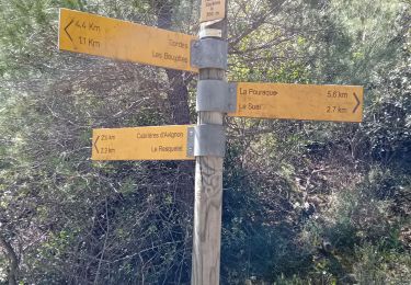
Départ croisement D2/D15(parking)
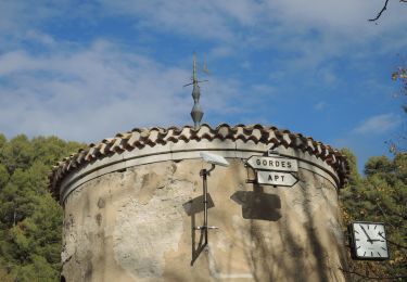
Le village des bories, abbaye de Sénanque, Gordes...merveilles du Liberon.
Plaatsbepaling
Land:
France
Regio :
Provence-Alpes-Côte d'Azur
Departement/Provincie :
Vaucluse
Gemeente :
Gordes
Locatie:
Unknown
Vertrek:(Dec)
Vertrek:(UTM)
676210 ; 4863291 (31T) N.
Opmerkingen
Wandeltochten in de omgeving
![Tocht Te voet Gordes - les gorges de la Véroncle - Photo](https://media.geolcdn.com/t/375/260/33601979-ee35-45ad-9f22-bd9d0e7a52b1.jpg&format=jpg&maxdim=2)
![Te voet Te voet](https://static1.geolcdn.com/sitytour/trail-icons/100.png)
les gorges de la Véroncle
Te voet
Medium
Gordes,
Provence-Alpes-Côte d'Azur,
Vaucluse,
France
![](/images/other/stat-length.png)
13 km | 17,6 km-effort
3h 59min
![](https://static1.geolcdn.com/siteimages/upload/files/16400158638029165_repeat_loop_refresh_sync_direction_icon.png)
Ja
![Mountainbike Mountainbike](https://static1.geolcdn.com/sitytour/trail-icons/202.png)
activity_9127223965
Mountainbike
Zeer moeilijk
Gordes,
Provence-Alpes-Côte d'Azur,
Vaucluse,
France
![](/images/other/stat-length.png)
35 km | 49 km-effort
3h 22min
![](https://static1.geolcdn.com/siteimages/upload/files/16400158638029165_repeat_loop_refresh_sync_direction_icon.png)
Ja
![Tocht Mountainbike Beaumettes - vttpll_47_LES_BEAUMETTES_Du_Calavon_au_col_de_Gordes - Photo](https://media.geolcdn.com/t/375/260/ext.jpg?maxdim=2&url=https%3A%2F%2Fstatic1.geolcdn.com%2Fsiteimages%2Fupload%2Ffiles%2F1524743154velo.jpg)
![Mountainbike Mountainbike](https://static1.geolcdn.com/sitytour/trail-icons/202.png)
vttpll_47_LES_BEAUMETTES_Du_Calavon_au_col_de_Gordes
Mountainbike
Gemakkelijk
(1)
Beaumettes,
Provence-Alpes-Côte d'Azur,
Vaucluse,
France
![](/images/other/stat-length.png)
13,1 km | 16,6 km-effort
1h 8min
![](https://static1.geolcdn.com/siteimages/upload/files/16400158638029165_repeat_loop_refresh_sync_direction_icon.png)
Ja
![Mountainbike Mountainbike](https://static1.geolcdn.com/sitytour/trail-icons/202.png)
Gordes_20210913_100058
Mountainbike
Heel gemakkelijk
Gordes,
Provence-Alpes-Côte d'Azur,
Vaucluse,
France
![](/images/other/stat-length.png)
20 km | 27 km-effort
Onbekend
![](https://static1.geolcdn.com/siteimages/upload/files/16400158638029165_repeat_loop_refresh_sync_direction_icon.png)
Ja
![Tocht Stappen Gordes - Gorges de Veroncle au départ de Gordes - Photo](https://media.geolcdn.com/t/375/260/cbfe0509-464e-4f5c-8aea-f3fe9fda94dc.jpg&format=jpg&maxdim=2)
![Stappen Stappen](https://static1.geolcdn.com/sitytour/trail-icons/101.png)
Gorges de Veroncle au départ de Gordes
Stappen
Moeilijk
Gordes,
Provence-Alpes-Côte d'Azur,
Vaucluse,
France
![](/images/other/stat-length.png)
19,3 km | 26 km-effort
5h 58min
![](https://static1.geolcdn.com/siteimages/upload/files/16400158638029165_repeat_loop_refresh_sync_direction_icon.png)
Ja
![Te voet Te voet](https://static1.geolcdn.com/sitytour/trail-icons/100.png)
Gordes 10 km
Te voet
Moeilijk
Gordes,
Provence-Alpes-Côte d'Azur,
Vaucluse,
France
![](/images/other/stat-length.png)
9,2 km | 13 km-effort
Onbekend
![](https://static1.geolcdn.com/siteimages/upload/files/16400158638029165_repeat_loop_refresh_sync_direction_icon.png)
Neen
![Stappen Stappen](https://static1.geolcdn.com/sitytour/trail-icons/101.png)
PF-Beaumettes - La Virginière
Stappen
Gemakkelijk
Beaumettes,
Provence-Alpes-Côte d'Azur,
Vaucluse,
France
![](/images/other/stat-length.png)
6,4 km | 7,5 km-effort
1h 45min
![](https://static1.geolcdn.com/siteimages/upload/files/16400158638029165_repeat_loop_refresh_sync_direction_icon.png)
Ja
![Tocht Stappen Gordes - Balcon des gorges de la Sénancole - Photo](https://media.geolcdn.com/t/375/260/ext.jpg?maxdim=2&url=https%3A%2F%2Fstatic1.geolcdn.com%2Fsiteimages%2Fupload%2Ffiles%2F1553511878bg_sport_marche.png)
![Stappen Stappen](https://static1.geolcdn.com/sitytour/trail-icons/101.png)
Balcon des gorges de la Sénancole
Stappen
Gemakkelijk
(3)
Gordes,
Provence-Alpes-Côte d'Azur,
Vaucluse,
France
![](/images/other/stat-length.png)
8,9 km | 11,9 km-effort
2h 37min
![](https://static1.geolcdn.com/siteimages/upload/files/16400158638029165_repeat_loop_refresh_sync_direction_icon.png)
Ja
![Tocht Stappen Cabrières-d'Avignon - Cabrieres les Boujolles - Photo](https://media.geolcdn.com/t/375/260/df96fd5d-a483-47bc-b98c-5989c41c96cb.jpg&format=jpg&maxdim=2)
![Stappen Stappen](https://static1.geolcdn.com/sitytour/trail-icons/101.png)
Cabrieres les Boujolles
Stappen
Moeilijk
Cabrières-d'Avignon,
Provence-Alpes-Côte d'Azur,
Vaucluse,
France
![](/images/other/stat-length.png)
12,9 km | 17,4 km-effort
6h 27min
![](https://static1.geolcdn.com/siteimages/upload/files/16400158638029165_repeat_loop_refresh_sync_direction_icon.png)
Neen