![](/images/other/stat-length.png)
![Tocht Stappen Dolceacqua - Convento de Dolceacqua - Photo](https://media.geolcdn.com/t/1900/400/ext.pjpeg?maxdim=2&url=https%3A%2F%2Fservices.sitytrail.com%2FGeolivesWS%2FDownloadMedia.ashx%3FTrailID%3D471497%26Media%3Dfix__20150913135938.jpg)
Convento de Dolceacqua
jeanclaude12
Gebruiker
![Lengte](/images/other/stat-length.png)
Lengte
5,4 km
![Max. hoogte](https://static1.geolcdn.com/siteimages/upload/files/1508320355ic_sort_altitude_max_24dp.png)
Max. hoogte
263 m
![Positief hoogteverschil](https://static1.geolcdn.com/siteimages/upload/files/1508320355ic_sort_den_pos_24dp.png)
Positief hoogteverschil
194 m
![Km-Effort](/images/other/stat-length.png)
Km-Effort
8,1 km
![Min. hoogte](https://static1.geolcdn.com/siteimages/upload/files/1508320355ic_sort_altitude_min_24dp.png)
Min. hoogte
63 m
![Negatief hoogteverschil](https://static1.geolcdn.com/siteimages/upload/files/1508320355ic_sort_den_neg_24dp.png)
Negatief hoogteverschil
230 m
![Boucle](https://static1.geolcdn.com/siteimages/upload/files/16400158638029165_repeat_loop_refresh_sync_direction_icon.png)
Boucle
Neen
Datum van aanmaak :
2015-09-13 00:00:00.0
Laatste wijziging :
2015-09-13 00:00:00.0
![Stappen](https://static1.geolcdn.com/sitytour/trail-icons/101.png)
2h25
Moeilijkheid : Gemakkelijk
![Scan deze QR-code om de tocht te openen in de SityTrail-applicatie](https://capi.geolives.com/qq0zvz2zws4bq2lad0pu/sitytour/trails/471497/qr.png?size=200)
Gratisgps-wandelapplicatie
Over ons
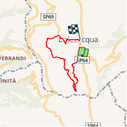
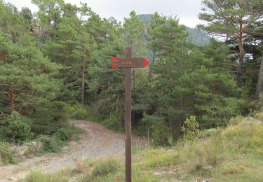
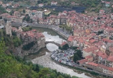
Tocht Stappen van 5,4 km beschikbaar op Ligurië, Imperia, Dolceacqua. Deze tocht wordt voorgesteld door jeanclaude12.
Beschrijving
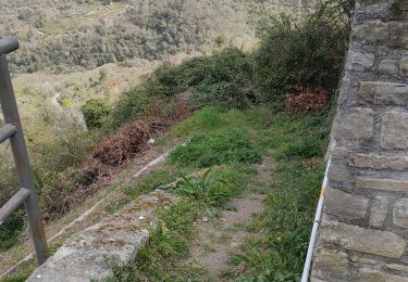
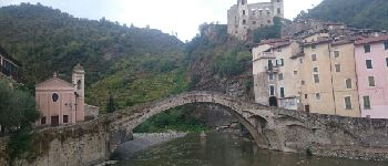
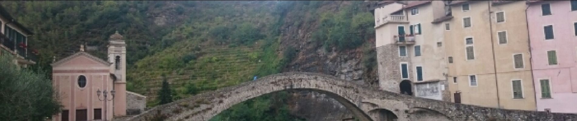
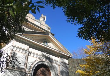
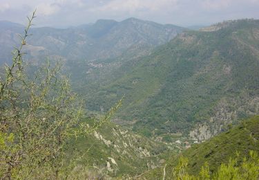
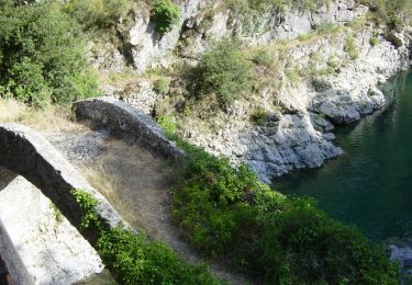
Circuit Convento sous la Cima d'Aurin pour une balade panoramique face et au-dessus du pittoresque village de Dolceacqua, situé sur la Nervia et uni au bourg par un pont médiéval, défini par Monet comme "un bijou de légèreté".
Plaatsbepaling
Land:
Italy
Regio :
Ligurië
Departement/Provincie :
Imperia
Gemeente :
Dolceacqua
Locatie:
Unknown
Vertrek:(Dec)
Vertrek:(UTM)
389233 ; 4855660 (32T) N.
Opmerkingen
Wandeltochten in de omgeving
![Tocht Te voet Airole - Anello del Gramondo - Photo](https://media.geolcdn.com/t/375/260/a83852fd-a46b-4921-bf67-5c05a5b0232d.jpeg&format=jpg&maxdim=2)
![Te voet Te voet](https://static1.geolcdn.com/sitytour/trail-icons/100.png)
Anello del Gramondo
Te voet
Gemakkelijk
Airole,
Ligurië,
Imperia,
Italy
![](/images/other/stat-length.png)
5 km | 7,9 km-effort
1h 47min
![](https://static1.geolcdn.com/siteimages/upload/files/16400158638029165_repeat_loop_refresh_sync_direction_icon.png)
Neen
![Tocht Te voet Airole - Anello del Gramondo - Photo](https://media.geolcdn.com/t/375/260/9fe7e0b5-8198-4662-8b3c-f48a75f07d69.jpeg&format=jpg&maxdim=2)
![Te voet Te voet](https://static1.geolcdn.com/sitytour/trail-icons/100.png)
Anello del Gramondo
Te voet
Moeilijk
Airole,
Ligurië,
Imperia,
Italy
![](/images/other/stat-length.png)
22 km | 40 km-effort
8h 59min
![](https://static1.geolcdn.com/siteimages/upload/files/16400158638029165_repeat_loop_refresh_sync_direction_icon.png)
Neen
![Tocht Te voet Airole - Anello del Colombin - Photo](https://media.geolcdn.com/t/375/260/16914238-78f2-4214-b920-a884aa69e150.jpeg&format=jpg&maxdim=2)
![Te voet Te voet](https://static1.geolcdn.com/sitytour/trail-icons/100.png)
Anello del Colombin
Te voet
Gemakkelijk
Airole,
Ligurië,
Imperia,
Italy
![](/images/other/stat-length.png)
6,4 km | 9,8 km-effort
2h 13min
![](https://static1.geolcdn.com/siteimages/upload/files/16400158638029165_repeat_loop_refresh_sync_direction_icon.png)
Neen
![Tocht Te voet Airole - Sentiero Balcone Mediterraneo T2 - Photo](https://media.geolcdn.com/t/375/260/16914238-78f2-4214-b920-a884aa69e150.jpeg&format=jpg&maxdim=2)
![Te voet Te voet](https://static1.geolcdn.com/sitytour/trail-icons/100.png)
Sentiero Balcone Mediterraneo T2
Te voet
Medium
Airole,
Ligurië,
Imperia,
Italy
![](/images/other/stat-length.png)
14,7 km | 26 km-effort
5h 49min
![](https://static1.geolcdn.com/siteimages/upload/files/16400158638029165_repeat_loop_refresh_sync_direction_icon.png)
Neen
![Tocht Te voet Dolceacqua - La Colla - Colla Sgora - Photo](https://media.geolcdn.com/t/375/260/b72f9800-410f-467b-95db-69956a32b123.jpeg&format=jpg&maxdim=2)
![Te voet Te voet](https://static1.geolcdn.com/sitytour/trail-icons/100.png)
La Colla - Colla Sgora
Te voet
Gemakkelijk
Dolceacqua,
Ligurië,
Imperia,
Italy
![](/images/other/stat-length.png)
9,5 km | 16,3 km-effort
3h 42min
![](https://static1.geolcdn.com/siteimages/upload/files/16400158638029165_repeat_loop_refresh_sync_direction_icon.png)
Neen
![Tocht Stappen Isolabona - Les Quatre Villages Perchés de la Nervia - Photo](https://media.geolcdn.com/t/375/260/ext.jpg?maxdim=2&url=https%3A%2F%2Fservices.sitytrail.com%2FGeolivesWS%2FDownloadMedia.ashx%3FTrailID%3D472082%26Media%3Dfix__20150915164631.jpg)
![Stappen Stappen](https://static1.geolcdn.com/sitytour/trail-icons/101.png)
Les Quatre Villages Perchés de la Nervia
Stappen
Medium
Isolabona,
Ligurië,
Imperia,
Italy
![](/images/other/stat-length.png)
14 km | 24 km-effort
6h 23min
![](https://static1.geolcdn.com/siteimages/upload/files/16400158638029165_repeat_loop_refresh_sync_direction_icon.png)
Neen
![Tocht Stappen Rocchetta Nervina - Du Logo Bin à Rocchetta Nervina - Photo](https://media.geolcdn.com/t/375/260/ext.jpg?maxdim=2&url=https%3A%2F%2Fservices.sitytrail.com%2FGeolivesWS%2FDownloadMedia.ashx%3FTrailID%3D471223%26Media%3Dfix__20150912182819.jpg)
![Stappen Stappen](https://static1.geolcdn.com/sitytour/trail-icons/101.png)
Du Logo Bin à Rocchetta Nervina
Stappen
Heel gemakkelijk
(1)
Rocchetta Nervina,
Ligurië,
Imperia,
Italy
![](/images/other/stat-length.png)
3,9 km | 5,4 km-effort
1h 33min
![](https://static1.geolcdn.com/siteimages/upload/files/16400158638029165_repeat_loop_refresh_sync_direction_icon.png)
Ja
![Tocht Stappen Dolceacqua - Dolceacqua - Photo](https://media.geolcdn.com/t/375/260/ext.jpg?maxdim=2&url=https%3A%2F%2Fstatic1.geolcdn.com%2Fsiteimages%2Fupload%2Ffiles%2F1553511878bg_sport_marche.png)
![Stappen Stappen](https://static1.geolcdn.com/sitytour/trail-icons/101.png)
![Tocht Stappen Perinaldo - apricale - Photo](https://media.geolcdn.com/t/375/260/38344c15-0851-4a86-9b60-9db057dcd64b.jpg&format=jpg&maxdim=2)
![Stappen Stappen](https://static1.geolcdn.com/sitytour/trail-icons/101.png)