Tocht Stappen Lourenzá - camino del norte   etapa 27   lourenza   gontan - Photo

camino del norte etapa 27 lourenza gontan

Randonnées de l'Institut National Géographique

© OpenStreetMap contributors
Lengte
Lengte
24 km
Max. hoogte
Max. hoogte
562 m
Positief hoogteverschil
899 m
Km-Effort
Km-Effort  
35 km
Min. hoogte
Min. hoogte
55 m
Negatief hoogteverschil
469 m
Boucle
Boucle
Neen
Datum van aanmaak :
2015-09-01 00:00:00.0
Laatste wijziging :
2015-09-01 00:00:00.0

(0 Bericht)

Stappen
Stappen
--
Moeilijkheid : Onbekend

Scan deze QR-code om de tocht te openen in de SityTrail-applicatie

Gratisgps-wandelapplicatie

Logo SityTrail SityTrail

IGN / Geografische instituten

SityTrail uit de App Store downloaden SityTrail uit Google Play downloaden

Logo SityTrail SityTrail World

De wereld gaat voor u open

SityTrail uit de App Store downloaden SityTrail uit Google Play downloaden SityTrail op Huawei AppGallery downloaden

Over ons

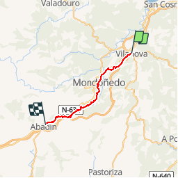
Tocht Stappen van 24 km beschikbaar op Galicië, Lugo, Lourenzá. Deze tocht wordt voorgesteld door Institut Géographique National.

Hoogteprofiel

Plaatsbepaling

Land:
Spain
Regio :
Galicië
Departement/Provincie :
Lugo
Gemeente :
Lourenzá
Locatie:
Unknown
Vertrek:(Dec)
Vertrek:(UTM)
637596 ; 4814480 (29T) N.

Wandeltochten in de omgeving

Tocht Stappen Lourenzá - 06-03 - Photo
Stappen
Rosko65

Stappen

Moeilijk
Lourenzá, Galicië, Lugo, Spain
27 km | 38 km-effort
7h 14min
Neen
Tocht Stappen Lourenzá - Vilanova Lourenza - Abadin - Photo
Stappen
JackyCouturier

Stappen

Medium
(1)
Lourenzá, Galicië, Lugo, Spain
25 km | 35 km-effort
2h 15min
Neen


Sluiten
Mijn abonnementen