Tocht Stappen Savignies - Savignies le détroit - Photo

Savignies le détroit

© OpenStreetMap contributors
Lengte
Lengte
10,2 km
Max. hoogte
Max. hoogte
221 m
Positief hoogteverschil
182 m
Km-Effort
Km-Effort  
12,6 km
Min. hoogte
Min. hoogte
144 m
Negatief hoogteverschil
181 m
Boucle
Boucle
Ja
Datum van aanmaak :
2015-09-01 00:00:00.0
Laatste wijziging :
2015-09-01 00:00:00.0

(1 Bericht)

Stappen
Stappen
2h45
Moeilijkheid : Medium

Scan deze QR-code om de tocht te openen in de SityTrail-applicatie

Gratisgps-wandelapplicatie

Logo SityTrail SityTrail

IGN / Geografische instituten

SityTrail uit de App Store downloaden SityTrail uit Google Play downloaden

Logo SityTrail SityTrail World

De wereld gaat voor u open

SityTrail uit de App Store downloaden SityTrail uit Google Play downloaden SityTrail op Huawei AppGallery downloaden

Over ons

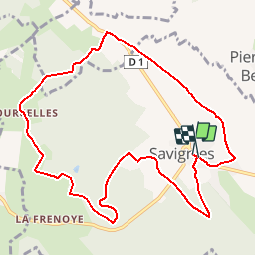
Tocht Stappen van 10,2 km beschikbaar op Hauts-de-France, Oise, Savignies. Deze tocht wordt voorgesteld door Marie-Claire-mcp.

Beschrijving

savignies , Beauvaisis, terre de potiers

Hoogteprofiel

Plaatsbepaling

Land:
France
Regio :
Hauts-de-France
Departement/Provincie :
Oise
Gemeente :
Savignies
Locatie:
Unknown
Vertrek:(Dec)
Vertrek:(UTM)
425023 ; 5479644 (31U) N.

Opmerkingen

Gelieve in te loggen om een commentaar of een beoordeling achter te laten


non


Wandeltochten in de omgeving

Tocht Mountainbike Lachapelle-aux-Pots - ACTIVE LOG 003 - Photo
Mountainbike
sebcar

Mountainbike

Medium
(1)
Lachapelle-aux-Pots, Hauts-de-France, Oise, France
19,1 km | 24 km-effort
1h 39min
Ja
Tocht Mountainbike Pierrefitte-en-Beauvaisis - Grand tour - Photo
Mountainbike
jjeletufe

Mountainbike

(1)
Pierrefitte-en-Beauvaisis, Hauts-de-France, Oise, France
30 km | 35 km-effort
1h 44min
Ja
Tocht Stappen Savignies - savignies - Photo
Stappen
Novomarquiens

Stappen

Gemakkelijk
Savignies, Hauts-de-France, Oise, France
9,3 km | 12 km-effort
3h 0min
Ja
Tocht Stappen Lachapelle-aux-Pots - Lachapelle-aux-pots - Héricourt - La Frénoye - Armentières - Photo
Stappen
Marie-Claire-mcp

Stappen

Moeilijk
Lachapelle-aux-Pots, Hauts-de-France, Oise, France
10,7 km | 13,7 km-effort
3h 6min
Ja
Tocht Stappen Lachapelle-aux-Pots - Lachapelle aux pots - Armentières 11 km - Photo
Stappen
Marie-Claire-mcp

Stappen

Moeilijk
Lachapelle-aux-Pots, Hauts-de-France, Oise, France
10,6 km | 13,5 km-effort
3h 4min
Ja
Tocht Stappen Lachapelle-aux-Pots - Lachapelle aux Pots - Rando santé 1 - Photo
Stappen
marcel.F

Stappen

Medium
Lachapelle-aux-Pots, Hauts-de-France, Oise, France
5,6 km | 6,4 km-effort
1h 24min
Ja
Tocht Stappen Lachapelle-aux-Pots - Lachapelle-aux-Pots - autour de la Crapaudière vers 2 - Photo
Stappen
marcel.F

Stappen

Gemakkelijk
Lachapelle-aux-Pots, Hauts-de-France, Oise, France
9,9 km | 11,5 km-effort
2h 32min
Ja
Tocht Stappen Lachapelle-aux-Pots - Lachapelle-aux-Pots - autour de la Crapaudière - Photo
Stappen
marcel.F

Stappen

Gemakkelijk
Lachapelle-aux-Pots, Hauts-de-France, Oise, France
9,4 km | 10,9 km-effort
2h 25min
Ja
Tocht Stappen Lachapelle-aux-Pots - Lachapelle aux pots Gare - Photo
Stappen
Marie-Claire-mcp

Stappen

Medium
Lachapelle-aux-Pots, Hauts-de-France, Oise, France
10,6 km | 12,4 km-effort
2h 37min
Ja


Sluiten
Mijn abonnementen