Tocht Stappen Saint-Germain-de-la-Coudre - Tour des Collines du Perche 8 - Photo

Tour des Collines du Perche 8

 togolo28
togolo28

Gebruiker

© OpenStreetMap contributors
Lengte
Lengte
28 km
Max. hoogte
Max. hoogte
210 m
Positief hoogteverschil
556 m
Km-Effort
Km-Effort  
35 km
Min. hoogte
Min. hoogte
91 m
Negatief hoogteverschil
542 m
Boucle
Boucle
Neen
Datum van aanmaak :
2016-10-18 00:00:00.0
Laatste wijziging :
2020-09-17 10:16:27.348

(0 Bericht)

Stappen
Stappen
7h30
Moeilijkheid : Medium

Scan deze QR-code om de tocht te openen in de SityTrail-applicatie

Gratisgps-wandelapplicatie

Logo SityTrail SityTrail

IGN / Geografische instituten

SityTrail uit de App Store downloaden SityTrail uit Google Play downloaden

Logo SityTrail SityTrail World

De wereld gaat voor u open

SityTrail uit de App Store downloaden SityTrail uit Google Play downloaden SityTrail op Huawei AppGallery downloaden

Over ons

Tocht Stappen van 28 km beschikbaar op Normandië, Orne, Saint-Germain-de-la-Coudre. Deze tocht wordt voorgesteld door togolo28.

Beschrijving

Le Tour des Collines du Perche à été réalisé par l'association « Itinéraires Ruraux » de Pervenchères (orne).
Vous pouvez consulter leur site internet :
http://itinerairesduperche.org

Hoogteprofiel

Plaatsbepaling

Land:
France
Regio :
Normandië
Departement/Provincie :
Orne
Gemeente :
Saint-Germain-de-la-Coudre
Locatie:
Unknown
Vertrek:(Dec)
Vertrek:(UTM)
322228 ; 5350304 (31U) N.

Wandeltochten in de omgeving

Tocht Stappen La Chapelle-Souëf - La Chapelle Souef - Les Feugerets 12 Km - Photo
Stappen
ODDAD78

Stappen

Medium
(1)
La Chapelle-Souëf, Normandië, Orne, France
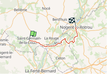
12 km | 14,1 km-effort
3h 6min
Ja
Tocht Stappen Bellou-le-Trichard - Bellou le Trichard - Photo
Stappen
darkpapa

Stappen

Moeilijk
Bellou-le-Trichard, Normandië, Orne, France
10 km | 12,5 km-effort
2h 49min
Ja
Tocht Stappen Saint-Cyr-la-Rosière - Au fil de la Rosière 7,1 Km - Photo
Stappen
ODDAD78

Stappen

Medium
Saint-Cyr-la-Rosière, Normandië, Orne, France
7,1 km | 8,7 km-effort
1h 57min
Ja
Tocht Stappen Val-au-Perche - Gémages - Igé 15 km - Photo
Stappen

Stappen

Gemakkelijk
Val-au-Perche, Normandië, Orne, France
14,7 km | 17,5 km-effort
7h 2min
Neen
Tocht Stappen Val-au-Perche - Gémages - Igé via Appenai-sous-Bellême 17 km - Photo
Stappen

Stappen

Gemakkelijk
Val-au-Perche, Normandië, Orne, France
16,7 km | 19,4 km-effort
55min
Neen
Tocht Stappen Val-au-Perche - Gémages - Saint-Cyr-la-Rosière 11 km - Photo
Stappen

Stappen

Gemakkelijk
Val-au-Perche, Normandië, Orne, France
11,2 km | 13,8 km-effort
2h 37min
Neen
Tocht Stappen Val-au-Perche - Gémages - Le-Theil-sur-Huisne (Val-au-Perche) 9,3 km - Photo
Stappen

Stappen

Gemakkelijk
Val-au-Perche, Normandië, Orne, France
9,3 km | 12,3 km-effort
2h 19min
Neen
Tocht Stappen Saint-Cyr-la-Rosière - Prieuré de Sainte-Gauburge - Saint-Aubin-des-Grois 5,7 km - Photo
Stappen

Stappen

Gemakkelijk
Saint-Cyr-la-Rosière, Normandië, Orne, France
5,7 km | 6,6 km-effort
1h 17min
Neen
Tocht Stappen Saint-Germain-de-la-Coudre - St Germain de la Coudre 18 - Photo
Stappen
togolo28

Stappen

Medium
(1)
Saint-Germain-de-la-Coudre, Normandië, Orne, France
18 km | 22 km-effort
4h 42min
Ja


Sluiten
Mijn abonnementen