![](/images/other/stat-length.png)
![Tocht Stappen Arboussols - 66 VINCA - MARCEVOL - GR36 - Sentier ancestral entre roches et murets - Photo](https://media.geolcdn.com/t/1900/400/ext.pjpeg?maxdim=2&url=https%3A%2F%2Fservices.sitytrail.com%2FGeolivesWS%2FDownloadMedia.ashx%3FTrailID%3D466314%26Media%3D20150831133810.jpg)
66 VINCA - MARCEVOL - GR36 - Sentier ancestral entre roches et murets
jeff66
Gebruiker
![Lengte](/images/other/stat-length.png)
![Max. hoogte](https://static1.geolcdn.com/siteimages/upload/files/1508320355ic_sort_altitude_max_24dp.png)
![Positief hoogteverschil](https://static1.geolcdn.com/siteimages/upload/files/1508320355ic_sort_den_pos_24dp.png)
![Km-Effort](/images/other/stat-length.png)
![Min. hoogte](https://static1.geolcdn.com/siteimages/upload/files/1508320355ic_sort_altitude_min_24dp.png)
![Negatief hoogteverschil](https://static1.geolcdn.com/siteimages/upload/files/1508320355ic_sort_den_neg_24dp.png)
![Boucle](https://static1.geolcdn.com/siteimages/upload/files/16400158638029165_repeat_loop_refresh_sync_direction_icon.png)
![Stappen](https://static1.geolcdn.com/sitytour/trail-icons/101.png)
1h55
Moeilijkheid : Moeilijk
![Scan deze QR-code om de tocht te openen in de SityTrail-applicatie](https://capi.geolives.com/qq0zvz2zws4bq2lad0pu/sitytour/trails/466314/qr.png?size=200)
Gratisgps-wandelapplicatie
Over ons
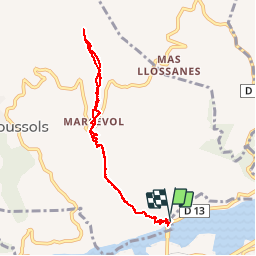
Tocht Stappen van 8,6 km beschikbaar op Occitanië, Pyrénées-Orientales, Arboussols. Deze tocht wordt voorgesteld door jeff66.
Beschrijving
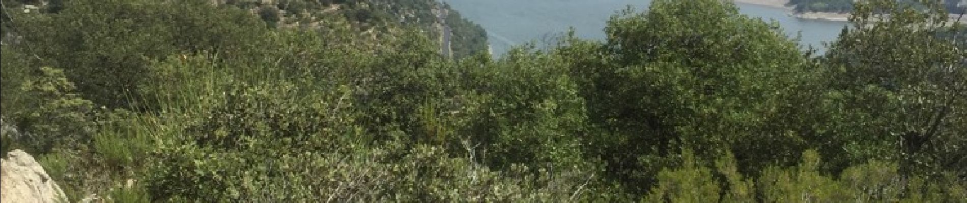
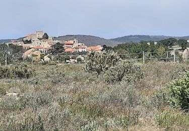
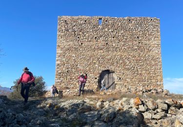
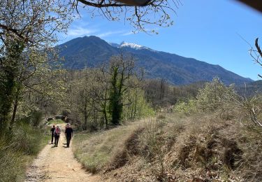
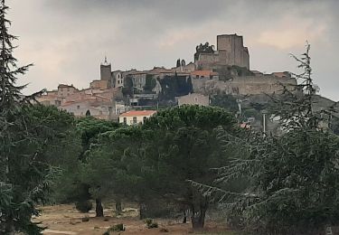
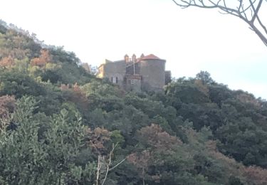
66 VINCA - MARCEVOL - par le GR36 - Sentier ancestral entre roches, pierres, pavages grossiers, murets, cistes, genévriers et chênes verts - parking près le pont sur le barrage de la têt - panorama sur la retenue, la vallée, VINCA,
Le Canigou - Roc d'en Coima - la Devesa - monastère : prieuré de MARCEVOL - le village - panorama sur Arboussols, le Canigou - PUIG Socarrat - piste DFCI F142 - route de Tarerach
Plaatsbepaling
Opmerkingen
Wandeltochten in de omgeving
![Tocht Mountainbike Vinça - parcours ronde de Sahorle 2013 - Photo](https://media.geolcdn.com/t/375/260/ext.jpg?maxdim=2&url=https%3A%2F%2Fstatic1.geolcdn.com%2Fsiteimages%2Fupload%2Ffiles%2F1524743154velo.jpg)
![Mountainbike Mountainbike](https://static1.geolcdn.com/sitytour/trail-icons/202.png)
Mountainbike
![](/images/other/stat-length.png)
![](https://static1.geolcdn.com/siteimages/upload/files/16400158638029165_repeat_loop_refresh_sync_direction_icon.png)
![Tocht sport Finestret - 20250109 petite boucle depuis Finestret - Photo](https://media.geolcdn.com/t/375/260/e154baa2-7741-43ff-8fd2-a9135305a5c2.jpg&format=jpg&maxdim=2)
sport
![](/images/other/stat-length.png)
![](https://static1.geolcdn.com/siteimages/upload/files/16400158638029165_repeat_loop_refresh_sync_direction_icon.png)
![Tocht Stappen Marquixanes - marquixanes - Photo](https://media.geolcdn.com/t/375/260/9f15ae53-8545-42f8-abb5-8d004f9aced2.jpg&format=jpg&maxdim=2)
![Stappen Stappen](https://static1.geolcdn.com/sitytour/trail-icons/101.png)
Stappen
![](/images/other/stat-length.png)
![](https://static1.geolcdn.com/siteimages/upload/files/16400158638029165_repeat_loop_refresh_sync_direction_icon.png)
![Tocht Stappen Montalba-le-Château - Montauban le château corral grandes or - Photo](https://media.geolcdn.com/t/375/260/4e0c3970-675f-4ac8-9536-c3e289d07d9a.jpg&format=jpg&maxdim=2)
![Stappen Stappen](https://static1.geolcdn.com/sitytour/trail-icons/101.png)
Stappen
![](/images/other/stat-length.png)
![](https://static1.geolcdn.com/siteimages/upload/files/16400158638029165_repeat_loop_refresh_sync_direction_icon.png)
![Tocht Stappen Arboussols - Marcevol - Photo](https://media.geolcdn.com/t/375/260/c36f51d8-a44d-419f-a023-7a6ff9003ad5.jpg&format=jpg&maxdim=2)
![Stappen Stappen](https://static1.geolcdn.com/sitytour/trail-icons/101.png)
Stappen
![](/images/other/stat-length.png)
![](https://static1.geolcdn.com/siteimages/upload/files/16400158638029165_repeat_loop_refresh_sync_direction_icon.png)
![Tocht Stappen Tarerach - Tarerach - Photo](https://media.geolcdn.com/t/375/260/ac55caa1-a948-4bf7-87aa-6f2d79de33ca.jpg&format=jpg&maxdim=2)
![Stappen Stappen](https://static1.geolcdn.com/sitytour/trail-icons/101.png)
Stappen
![](/images/other/stat-length.png)
![](https://static1.geolcdn.com/siteimages/upload/files/16400158638029165_repeat_loop_refresh_sync_direction_icon.png)
![Tocht Stappen Los Masos - Los Masos Lionat - Photo](https://media.geolcdn.com/t/375/260/125a95df-244e-4de4-8ca5-3e656269ddeb.jpg&format=jpg&maxdim=2)
![Stappen Stappen](https://static1.geolcdn.com/sitytour/trail-icons/101.png)
Stappen
![](/images/other/stat-length.png)
![](https://static1.geolcdn.com/siteimages/upload/files/16400158638029165_repeat_loop_refresh_sync_direction_icon.png)
![Tocht Stappen Montalba-le-Château - montant a - Photo](https://media.geolcdn.com/t/375/260/bab4a258-ec8b-477d-a8cf-388a6f2cb82a.jpg&format=jpg&maxdim=2)
![Stappen Stappen](https://static1.geolcdn.com/sitytour/trail-icons/101.png)
Stappen
![](/images/other/stat-length.png)
![](https://static1.geolcdn.com/siteimages/upload/files/16400158638029165_repeat_loop_refresh_sync_direction_icon.png)
![Tocht Stappen Rodès - 20221222 Rodés - Domanova…. Boucle - Photo](https://media.geolcdn.com/t/375/260/a3e631e7-3bf6-4340-8786-449d4c4dba31.jpg&format=jpg&maxdim=2)
![Stappen Stappen](https://static1.geolcdn.com/sitytour/trail-icons/101.png)
Stappen
![](/images/other/stat-length.png)
![](https://static1.geolcdn.com/siteimages/upload/files/16400158638029165_repeat_loop_refresh_sync_direction_icon.png)