Tocht Stappen Font-Romeu-Odeillo-Via - Pic dels Moros - Photo
 gberger
gberger

Gebruiker

© OpenStreetMap contributors
Lengte
Lengte
12,1 km
Max. hoogte
Max. hoogte
2135 m
Positief hoogteverschil
321 m
Km-Effort
Km-Effort  
16,4 km
Min. hoogte
Min. hoogte
1991 m
Negatief hoogteverschil
322 m
Boucle
Boucle
Ja
Datum van aanmaak :
2015-09-20 00:00:00.0
Laatste wijziging :
2015-09-20 00:00:00.0

(0 Bericht)

Stappen
Stappen
3h41
Moeilijkheid : Heel gemakkelijk

Scan deze QR-code om de tocht te openen in de SityTrail-applicatie

Gratisgps-wandelapplicatie

Logo SityTrail SityTrail

IGN / Geografische instituten

SityTrail uit de App Store downloaden SityTrail uit Google Play downloaden

Logo SityTrail SityTrail World

De wereld gaat voor u open

SityTrail uit de App Store downloaden SityTrail uit Google Play downloaden SityTrail op Huawei AppGallery downloaden

Over ons

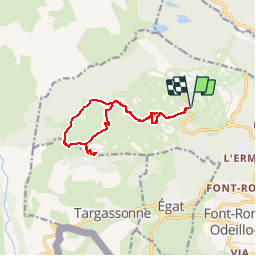
Tocht Stappen van 12,1 km beschikbaar op Occitanië, Pyrénées-Orientales, Font-Romeu-Odeillo-Via. Deze tocht wordt voorgesteld door gberger.

Beschrijving

Pettite randonnée facile dans les prairies.  Belle vue depuis le pic dels Moros.

Hoogteprofiel

Foto's

POI's

POI Font-Romeu-Odeillo-Via - Abri de berger - Photo
gberger
FONT-ROMEU-ODEILLO-VIA 
POI Font-Romeu-Odeillo-Via - Refuge de la Calme - Photo
gberger
FONT-ROMEU-ODEILLO-VIA 
POI Font-Romeu-Odeillo-Via - Massif du Carlit - Photo
gberger
FONT-ROMEU-ODEILLO-VIA 
POI Font-Romeu-Odeillo-Via - Pic dels Moros - Photo
gberger
FONT-ROMEU-ODEILLO-VIA 

Plaatsbepaling

Land:
France
Regio :
Occitanië
Departement/Provincie :
Pyrénées-Orientales
Gemeente :
Font-Romeu-Odeillo-Via
Locatie:
Unknown
Vertrek:(Dec)
Vertrek:(UTM)
419808 ; 4708554 (31T) N.

Wandeltochten in de omgeving

Tocht Stappen Font-Romeu-Odeillo-Via - Coll del Pam lac des  Bouillouses - Photo
Stappen
jcmartin

Stappen

Medium
(2)
Font-Romeu-Odeillo-Via, Occitanië, Pyrénées-Orientales, France
13,3 km | 19,3 km-effort
4h 10min
Ja
Tocht Sneeuwschoenen Font-Romeu-Odeillo-Via - pic dels moros - Photo
Sneeuwschoenen
jpipacific

Sneeuwschoenen

Medium
(1)
Font-Romeu-Odeillo-Via, Occitanië, Pyrénées-Orientales, France
12,6 km | 19,4 km-effort
4h 46min
Ja
Tocht Sneeuwschoenen Les Angles - Lac d Aude -Refuge Bernardi les Angles - Photo
Sneeuwschoenen
MarieFrancoise

Sneeuwschoenen

Medium
(1)
Les Angles, Occitanië, Pyrénées-Orientales, France
13,9 km | 19,1 km-effort
5h 44min
Ja
Tocht Stappen Les Angles - le tour des lacs de carli - Photo
Stappen
mouss65

Stappen

Medium
(2)
Les Angles, Occitanië, Pyrénées-Orientales, France
11,4 km | 16,6 km-effort
3h 51min
Neen
Tocht Stappen Les Angles - Rando des 12 lacs - Photo
Stappen
stp130678

Stappen

Gemakkelijk
(1)
Les Angles, Occitanië, Pyrénées-Orientales, France
14,1 km | 20 km-effort
6h 30min
Ja
Tocht Stappen Font-Romeu-Odeillo-Via - Font Romeu Egat - Photo
Stappen
crijack

Stappen

Medium
(2)
Font-Romeu-Odeillo-Via, Occitanië, Pyrénées-Orientales, France
2,5 km | 3,4 km-effort
44min
Ja
Tocht Sneeuwschoenen Font-Romeu-Odeillo-Via - Pic dels Moros avec Pierre - Photo
Sneeuwschoenen
jpipacific

Sneeuwschoenen

Medium
(1)
Font-Romeu-Odeillo-Via, Occitanië, Pyrénées-Orientales, France
10,5 km | 15,9 km-effort
4h 4min
Ja
Tocht Stappen Égat - Egat  Puig  Moro - Photo
Stappen
ohelluin

Stappen

Medium
(1)
Égat, Occitanië, Pyrénées-Orientales, France
13,4 km | 19,3 km-effort
4h 51min
Ja
Tocht Stappen Égat - La croix d'Egat - Photo
Stappen
ochamley

Stappen

Gemakkelijk
(1)
Égat, Occitanië, Pyrénées-Orientales, France
7,1 km | 10,4 km-effort
2h 2min
Ja


Sluiten
Mijn abonnementen