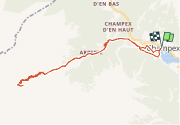
![](/images/other/stat-length.png)
![Tocht Stappen Orsières - Bisse de Champex - Val d'Arpette - Photo](https://media.geolcdn.com/t/1900/400/ext.pjpeg?maxdim=2&url=https%3A%2F%2Fservices.sitytrail.com%2FGeolivesWS%2FDownloadMedia.ashx%3FTrailID%3D462081%26Media%3D16497209-0c13-4178-ade4-7ad0be010c5e.jpg)
Bisse de Champex - Val d'Arpette
duamerg
Gebruiker
![Lengte](/images/other/stat-length.png)
![Max. hoogte](https://static1.geolcdn.com/siteimages/upload/files/1508320355ic_sort_altitude_max_24dp.png)
![Positief hoogteverschil](https://static1.geolcdn.com/siteimages/upload/files/1508320355ic_sort_den_pos_24dp.png)
![Km-Effort](/images/other/stat-length.png)
![Min. hoogte](https://static1.geolcdn.com/siteimages/upload/files/1508320355ic_sort_altitude_min_24dp.png)
![Negatief hoogteverschil](https://static1.geolcdn.com/siteimages/upload/files/1508320355ic_sort_den_neg_24dp.png)
![Boucle](https://static1.geolcdn.com/siteimages/upload/files/16400158638029165_repeat_loop_refresh_sync_direction_icon.png)
![Stappen](https://static1.geolcdn.com/sitytour/trail-icons/101.png)
4h26
Moeilijkheid : Medium
![Scan deze QR-code om de tocht te openen in de SityTrail-applicatie](https://capi.geolives.com/qq0zvz2zws4bq2lad0pu/sitytour/trails/462081/qr.png?size=200)
Gratisgps-wandelapplicatie
Over ons
Tocht Stappen van 11,5 km beschikbaar op Valais/Wallis, Entremont, Orsières. Deze tocht wordt voorgesteld door duamerg.
Beschrijving
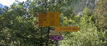
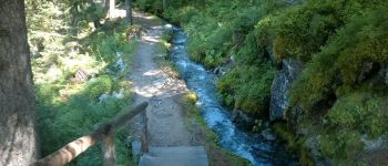
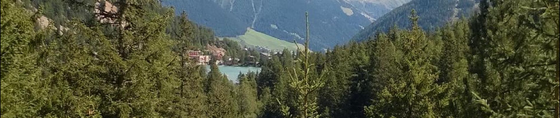
Laisser la voiture à la fin du lac. Rejoindre la route forestière. A la hauteur du télésiège suivre le bisse jusqu'à la prise d'eau. La pente se fait plus raide pour rejoindre le val d'Arpette. Un restaurant est à disposition au début du val.
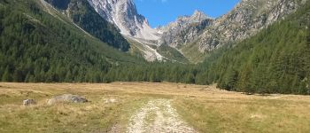
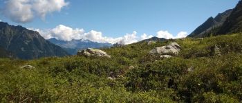
Chemin paisible jusqu'au dernier quart ou une rude montée vous attend pour atteindre un nouveau plateau, ancienne moraine du glacier.
Retour par le même chemin.
Les courageux peuvent bien sur continuer mais attention au dénivelé et temps de parcours (voir photo).
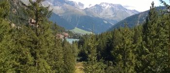
Joli parcours dans une vallée sauvage avec un joli bisse très fourni en eau.
Plaatsbepaling
Opmerkingen
Wandeltochten in de omgeving
![Tocht Te voet Orsières - Chemins pédestre de montagne, commune d'Orsières - Photo](https://media.geolcdn.com/t/375/260/6dfeee0d-887b-4c9c-aefd-3dcd0ea22569.jpeg&format=jpg&maxdim=2)
![Te voet Te voet](https://static1.geolcdn.com/sitytour/trail-icons/100.png)
Te voet
![](/images/other/stat-length.png)
![](https://static1.geolcdn.com/siteimages/upload/files/16400158638029165_repeat_loop_refresh_sync_direction_icon.png)
![Tocht Te voet Orsières - sentier du Devin - Photo](https://media.geolcdn.com/t/375/260/1486fc85-352e-404e-b600-0f3d7bac1924.jpeg&format=jpg&maxdim=2)
![Te voet Te voet](https://static1.geolcdn.com/sitytour/trail-icons/100.png)
Te voet
![](/images/other/stat-length.png)
![](https://static1.geolcdn.com/siteimages/upload/files/16400158638029165_repeat_loop_refresh_sync_direction_icon.png)
![Tocht Te voet Orsières - Chemins pédestre, commune d'Orsières - Photo](https://media.geolcdn.com/t/375/260/70edd484-9073-4e02-96d0-3d17425bab34.jpeg&format=jpg&maxdim=2)
![Te voet Te voet](https://static1.geolcdn.com/sitytour/trail-icons/100.png)
Te voet
![](/images/other/stat-length.png)
![](https://static1.geolcdn.com/siteimages/upload/files/16400158638029165_repeat_loop_refresh_sync_direction_icon.png)
![Tocht Te voet Bovernier - Chemins pédestre de montagne, région Entremont - Photo](https://media.geolcdn.com/t/375/260/8965cd81-5f88-4628-9726-209c4b98c789.jpeg&format=jpg&maxdim=2)
![Te voet Te voet](https://static1.geolcdn.com/sitytour/trail-icons/100.png)
Te voet
![](/images/other/stat-length.png)
![](https://static1.geolcdn.com/siteimages/upload/files/16400158638029165_repeat_loop_refresh_sync_direction_icon.png)
![Tocht Stappen Liddes - Combe de l’A - Photo](https://media.geolcdn.com/t/375/260/80b3ab05-1db2-4115-987f-2856a50ccafd.jpg&format=jpg&maxdim=2)
![Stappen Stappen](https://static1.geolcdn.com/sitytour/trail-icons/101.png)
Stappen
![](/images/other/stat-length.png)
![](https://static1.geolcdn.com/siteimages/upload/files/16400158638029165_repeat_loop_refresh_sync_direction_icon.png)
![Tocht Te voet Orsières - Raccard du blé - Photo](https://media.geolcdn.com/t/375/260/e3af305e-4edc-4919-bcad-22d8b69ac232.jpeg&format=jpg&maxdim=2)
![Te voet Te voet](https://static1.geolcdn.com/sitytour/trail-icons/100.png)
Te voet
![](/images/other/stat-length.png)
![](https://static1.geolcdn.com/siteimages/upload/files/16400158638029165_repeat_loop_refresh_sync_direction_icon.png)
![Tocht Stappen Orsières - TMB 08 - Relais d'Arpette -> Trient - Photo](https://media.geolcdn.com/t/375/260/879d1358-40ae-4393-aa0f-3cd2dbd6e081.jpg&format=jpg&maxdim=2)
![Stappen Stappen](https://static1.geolcdn.com/sitytour/trail-icons/101.png)
Stappen
![](/images/other/stat-length.png)
![](https://static1.geolcdn.com/siteimages/upload/files/16400158638029165_repeat_loop_refresh_sync_direction_icon.png)
![Tocht Sneeuwschoenen Orsières - Champex Lac - La Breya - Champex Lac - Photo](https://media.geolcdn.com/t/375/260/6555df26-5e72-41d3-9ea4-2761199f667f.jpg&format=jpg&maxdim=2)
![Sneeuwschoenen Sneeuwschoenen](https://static1.geolcdn.com/sitytour/trail-icons/504.png)
Sneeuwschoenen
![](/images/other/stat-length.png)
![](https://static1.geolcdn.com/siteimages/upload/files/16400158638029165_repeat_loop_refresh_sync_direction_icon.png)
![Tocht Stappen Orsières - CMX ZRMT Étape 2 Champex Cabane de Mille - Photo](https://media.geolcdn.com/t/375/260/ext.jpg?maxdim=2&url=https%3A%2F%2Fservices.sitytrail.com%2FGeolivesWS%2FDownloadMedia.ashx%3FTrailID%3D635928%26Media%3Dfix__20160914135625.jpg)
![Stappen Stappen](https://static1.geolcdn.com/sitytour/trail-icons/101.png)
Stappen
![](/images/other/stat-length.png)
![](https://static1.geolcdn.com/siteimages/upload/files/16400158638029165_repeat_loop_refresh_sync_direction_icon.png)