![](/images/other/stat-length.png)
![Tocht Fiets Villeneuve (VD) - Coteaux du Chablais - Berge du Rhõne - Photo](https://media.geolcdn.com/t/1900/400/ext.pjpeg?maxdim=2&url=https%3A%2F%2Fservices.sitytrail.com%2FGeolivesWS%2FDownloadMedia.ashx%3FTrailID%3D461969%26Media%3D20150821110429.jpg)
Coteaux du Chablais - Berge du Rhõne
danihz
Gebruiker
![Lengte](/images/other/stat-length.png)
Lengte
50 km
![Max. hoogte](https://static1.geolcdn.com/siteimages/upload/files/1508320355ic_sort_altitude_max_24dp.png)
Max. hoogte
601 m
![Positief hoogteverschil](https://static1.geolcdn.com/siteimages/upload/files/1508320355ic_sort_den_pos_24dp.png)
Positief hoogteverschil
686 m
![Km-Effort](/images/other/stat-length.png)
Km-Effort
59 km
![Min. hoogte](https://static1.geolcdn.com/siteimages/upload/files/1508320355ic_sort_altitude_min_24dp.png)
Min. hoogte
371 m
![Negatief hoogteverschil](https://static1.geolcdn.com/siteimages/upload/files/1508320355ic_sort_den_neg_24dp.png)
Negatief hoogteverschil
685 m
![Boucle](https://static1.geolcdn.com/siteimages/upload/files/16400158638029165_repeat_loop_refresh_sync_direction_icon.png)
Boucle
Neen
Datum van aanmaak :
2015-08-21 00:00:00.0
Laatste wijziging :
2015-08-21 00:00:00.0
![Fiets](https://static1.geolcdn.com/sitytour/trail-icons/200.png)
2h24
Moeilijkheid : Medium
![Scan deze QR-code om de tocht te openen in de SityTrail-applicatie](https://capi.geolives.com/qq0zvz2zws4bq2lad0pu/sitytour/trails/461969/qr.png?size=200)
Gratisgps-wandelapplicatie
Over ons
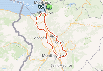
Tocht Fiets van 50 km beschikbaar op Waadland, District d'Aigle, Villeneuve (VD). Deze tocht wordt voorgesteld door danihz.
Beschrijving
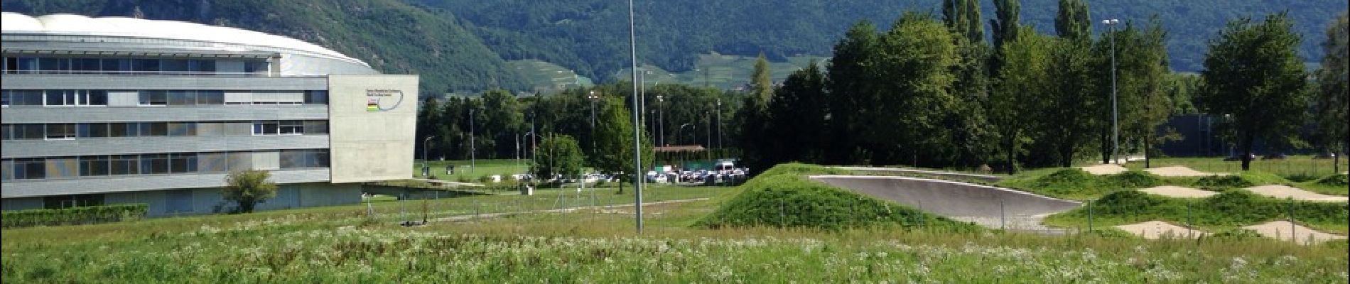
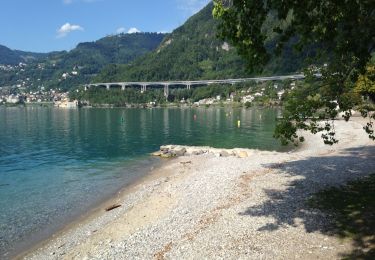
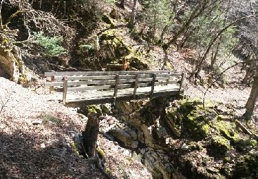
Balade sympa de début de saison sur de petites routes pratiquement sans circulation. La plaine du Rhône, les coteaux du Chablais à travers le vignoble, puis retour le long des berges du Rhône en passant par le centre mondial du cyclisme près d'Aigle
Plaatsbepaling
Land:
Switzerland
Regio :
Waadland
Departement/Provincie :
District d'Aigle
Gemeente :
Villeneuve (VD)
Locatie:
Unknown
Vertrek:(Dec)
Vertrek:(UTM)
340644 ; 5139986 (32T) N.
Opmerkingen
Wandeltochten in de omgeving
![Tocht Stappen Montreux - Montreux - Villeneuve - Le Bouveret - Photo](https://media.geolcdn.com/t/375/260/ext.jpg?maxdim=2&url=https%3A%2F%2Fstatic1.geolcdn.com%2Fsiteimages%2Fupload%2Ffiles%2F1553511878bg_sport_marche.png)
![Stappen Stappen](https://static1.geolcdn.com/sitytour/trail-icons/101.png)
Montreux - Villeneuve - Le Bouveret
Stappen
Heel gemakkelijk
(1)
Montreux,
Waadland,
District de la Riviera-Pays-d’Enhaut,
Switzerland
![](/images/other/stat-length.png)
14,5 km | 16,4 km-effort
Onbekend
![](https://static1.geolcdn.com/siteimages/upload/files/16400158638029165_repeat_loop_refresh_sync_direction_icon.png)
Neen
![Tocht Stappen Villeneuve (VD) - Bois de Chillon - Photo](https://media.geolcdn.com/t/375/260/ext.jpg?maxdim=2&url=https%3A%2F%2Fservices.sitytrail.com%2FGeolivesWS%2FDownloadMedia.ashx%3FTrailID%3D470065%26Media%3D20150908161735.jpg)
![Stappen Stappen](https://static1.geolcdn.com/sitytour/trail-icons/101.png)
Bois de Chillon
Stappen
Gemakkelijk
Villeneuve (VD),
Waadland,
District d'Aigle,
Switzerland
![](/images/other/stat-length.png)
10,6 km | 16,1 km-effort
2h 30min
![](https://static1.geolcdn.com/siteimages/upload/files/16400158638029165_repeat_loop_refresh_sync_direction_icon.png)
Ja
![Tocht Stappen Roche (VD) - Boucle d Arvel Joux Verte - Photo](https://media.geolcdn.com/t/375/260/ext.jpg?maxdim=2&url=https%3A%2F%2Fservices.sitytrail.com%2FGeolivesWS%2FDownloadMedia.ashx%3FTrailID%3D264798%26Media%3Dfix__20140409134802.jpg)
![Stappen Stappen](https://static1.geolcdn.com/sitytour/trail-icons/101.png)
Boucle d Arvel Joux Verte
Stappen
Medium
Roche (VD),
Waadland,
District d'Aigle,
Switzerland
![](/images/other/stat-length.png)
6,9 km | 18,7 km-effort
1h 44min
![](https://static1.geolcdn.com/siteimages/upload/files/16400158638029165_repeat_loop_refresh_sync_direction_icon.png)
Ja
![Tocht Stappen Veytaux - st_Rochers-de-Naye - Photo](https://media.geolcdn.com/t/375/260/ext.jpg?maxdim=2&url=https%3A%2F%2Fstatic1.geolcdn.com%2Fsiteimages%2Fupload%2Ffiles%2F1553511878bg_sport_marche.png)
![Stappen Stappen](https://static1.geolcdn.com/sitytour/trail-icons/101.png)
st_Rochers-de-Naye
Stappen
Heel gemakkelijk
Veytaux,
Waadland,
District de la Riviera-Pays-d’Enhaut,
Switzerland
![](/images/other/stat-length.png)
6,4 km | 11,1 km-effort
1h 42min
![](https://static1.geolcdn.com/siteimages/upload/files/16400158638029165_repeat_loop_refresh_sync_direction_icon.png)
Neen
![Tocht Stappen Montreux - Rando Caux Jaman Nayes - Photo](https://media.geolcdn.com/t/375/260/ext.jpg?maxdim=2&url=https%3A%2F%2Fstatic1.geolcdn.com%2Fsiteimages%2Fupload%2Ffiles%2F1553511878bg_sport_marche.png)
![Stappen Stappen](https://static1.geolcdn.com/sitytour/trail-icons/101.png)
Rando Caux Jaman Nayes
Stappen
Moeilijk
Montreux,
Waadland,
District de la Riviera-Pays-d’Enhaut,
Switzerland
![](/images/other/stat-length.png)
15,8 km | 29 km-effort
4h 17min
![](https://static1.geolcdn.com/siteimages/upload/files/16400158638029165_repeat_loop_refresh_sync_direction_icon.png)
Ja
![Tocht Te voet Montreux - Les Gorges du Chauderon - Photo](https://media.geolcdn.com/t/375/260/ext.jpg?maxdim=2&url=https%3A%2F%2Fstatic1.geolcdn.com%2Fsiteimages%2Fupload%2Ffiles%2F1545311037marcheuse_200dpi.jpg)
![Te voet Te voet](https://static1.geolcdn.com/sitytour/trail-icons/100.png)
Les Gorges du Chauderon
Te voet
Gemakkelijk
Montreux,
Waadland,
District de la Riviera-Pays-d’Enhaut,
Switzerland
![](/images/other/stat-length.png)
6,7 km | 11,8 km-effort
2h 40min
![](https://static1.geolcdn.com/siteimages/upload/files/16400158638029165_repeat_loop_refresh_sync_direction_icon.png)
Ja
![Tocht Te voet Montreux - Itinéraire course à pied : Boucle Hauts-de-Caux - Sonchaux - Photo](https://media.geolcdn.com/t/375/260/ext.jpg?maxdim=2&url=https%3A%2F%2Fstatic1.geolcdn.com%2Fsiteimages%2Fupload%2Ffiles%2F1545311037marcheuse_200dpi.jpg)
![Te voet Te voet](https://static1.geolcdn.com/sitytour/trail-icons/100.png)
Itinéraire course à pied : Boucle Hauts-de-Caux - Sonchaux
Te voet
Gemakkelijk
Montreux,
Waadland,
District de la Riviera-Pays-d’Enhaut,
Switzerland
![](/images/other/stat-length.png)
9,8 km | 15,4 km-effort
3h 30min
![](https://static1.geolcdn.com/siteimages/upload/files/16400158638029165_repeat_loop_refresh_sync_direction_icon.png)
Ja
![Tocht Te voet Villeneuve (VD) - La balade des hameaux - Photo](https://media.geolcdn.com/t/375/260/ext.jpg?maxdim=2&url=https%3A%2F%2Fstatic1.geolcdn.com%2Fsiteimages%2Fupload%2Ffiles%2F1545311037marcheuse_200dpi.jpg)
![Te voet Te voet](https://static1.geolcdn.com/sitytour/trail-icons/100.png)
La balade des hameaux
Te voet
Gemakkelijk
Villeneuve (VD),
Waadland,
District d'Aigle,
Switzerland
![](/images/other/stat-length.png)
6,6 km | 10,5 km-effort
2h 22min
![](https://static1.geolcdn.com/siteimages/upload/files/16400158638029165_repeat_loop_refresh_sync_direction_icon.png)
Ja
![Tocht Te voet Villeneuve (VD) - Les Grangettes - Photo](https://media.geolcdn.com/t/375/260/ext.jpg?maxdim=2&url=https%3A%2F%2Fstatic1.geolcdn.com%2Fsiteimages%2Fupload%2Ffiles%2F1545311037marcheuse_200dpi.jpg)
![Te voet Te voet](https://static1.geolcdn.com/sitytour/trail-icons/100.png)
Les Grangettes
Te voet
Gemakkelijk
Villeneuve (VD),
Waadland,
District d'Aigle,
Switzerland
![](/images/other/stat-length.png)
8,2 km | 9 km-effort
2h 2min
![](https://static1.geolcdn.com/siteimages/upload/files/16400158638029165_repeat_loop_refresh_sync_direction_icon.png)
Ja