![](/images/other/stat-length.png)
![Tocht Stappen Acquigny - Acquigny - Photo](https://media.geolcdn.com/t/1900/400/ext.pjpeg?maxdim=2&url=https%3A%2F%2Fstatic1.geolcdn.com%2Fsiteimages%2Fupload%2Ffiles%2F1553511878bg_sport_marche.png)
Acquigny
BaladesEN
Gebruiker
![Lengte](/images/other/stat-length.png)
![Max. hoogte](https://static1.geolcdn.com/siteimages/upload/files/1508320355ic_sort_altitude_max_24dp.png)
![Positief hoogteverschil](https://static1.geolcdn.com/siteimages/upload/files/1508320355ic_sort_den_pos_24dp.png)
![Km-Effort](/images/other/stat-length.png)
![Min. hoogte](https://static1.geolcdn.com/siteimages/upload/files/1508320355ic_sort_altitude_min_24dp.png)
![Negatief hoogteverschil](https://static1.geolcdn.com/siteimages/upload/files/1508320355ic_sort_den_neg_24dp.png)
![Boucle](https://static1.geolcdn.com/siteimages/upload/files/16400158638029165_repeat_loop_refresh_sync_direction_icon.png)
![Stappen](https://static1.geolcdn.com/sitytour/trail-icons/101.png)
3h22
Moeilijkheid : Gemakkelijk
![Scan deze QR-code om de tocht te openen in de SityTrail-applicatie](https://capi.geolives.com/qq0zvz2zws4bq2lad0pu/sitytour/trails/456253/qr.png?size=200)
Gratisgps-wandelapplicatie
Over ons
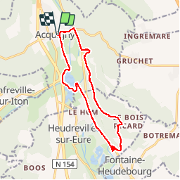
Tocht Stappen van 12,9 km beschikbaar op Normandië, Eure, Acquigny. Deze tocht wordt voorgesteld door BaladesEN.
Beschrijving
Nous partons d'Acquigny pour longer l'Iton et les anciennes ballastières aménagées en étang pour la pêche. Nous traversons l'Eure sur un ancien pont ferroviaire et suivons l'ancienne voie ferrée jusqu'à Heudreville-sur-Eure. Cette voie ferrée a été utilisée, dans les années 50, quand les rails étaient encore en place, pour le tournage du film 'le train'. Les paysages le long de l'Iton, de l'étang et de l'Eure sont très agréables. Nous montons ensuite vers le Bois Ricard en découvrant la vue sur la vallée de l'Eure. Nous marchons dans le bois des Thillers jusqu'à Cambremont, puis descendons vers le château d'Acquigny. BaladesEnNormandie.fr
Plaatsbepaling
Opmerkingen
Wandeltochten in de omgeving
![Tocht Stappen La Haye-le-Comte - La Haye le Comte - Photo](https://media.geolcdn.com/t/375/260/ext.jpg?maxdim=2&url=https%3A%2F%2Fstatic1.geolcdn.com%2Fsiteimages%2Fupload%2Ffiles%2F1553511878bg_sport_marche.png)
![Stappen Stappen](https://static1.geolcdn.com/sitytour/trail-icons/101.png)
Stappen
![](/images/other/stat-length.png)
![](https://static1.geolcdn.com/siteimages/upload/files/16400158638029165_repeat_loop_refresh_sync_direction_icon.png)
![Stappen Stappen](https://static1.geolcdn.com/sitytour/trail-icons/101.png)
Stappen
![](/images/other/stat-length.png)
![](https://static1.geolcdn.com/siteimages/upload/files/16400158638029165_repeat_loop_refresh_sync_direction_icon.png)
![Tocht Wegfiets Pinterville - Pinterville aller retour - Photo](https://media.geolcdn.com/t/375/260/8eeb09f6-87db-4d49-a311-8b1c5c1f2921.jpg&format=jpg&maxdim=2)
![Wegfiets Wegfiets](https://static1.geolcdn.com/sitytour/trail-icons/201.png)
Wegfiets
![](/images/other/stat-length.png)
![](https://static1.geolcdn.com/siteimages/upload/files/16400158638029165_repeat_loop_refresh_sync_direction_icon.png)
![Tocht Stappen Amfreville-sur-Iton - rando amfreville sur iton - Photo](https://media.geolcdn.com/t/375/260/1ae1478e-8362-45f5-95df-868478733425.jpg&format=jpg&maxdim=2)
![Stappen Stappen](https://static1.geolcdn.com/sitytour/trail-icons/101.png)
Stappen
![](/images/other/stat-length.png)
![](https://static1.geolcdn.com/siteimages/upload/files/16400158638029165_repeat_loop_refresh_sync_direction_icon.png)
![Tocht Stappen Heudebouville - 20230202-Heudebouville - Photo](https://media.geolcdn.com/t/375/260/9a040f26-251c-4887-9b11-b6efcdf3ee8d.jpg&format=jpg&maxdim=2)
![Stappen Stappen](https://static1.geolcdn.com/sitytour/trail-icons/101.png)
Stappen
![](/images/other/stat-length.png)
![](https://static1.geolcdn.com/siteimages/upload/files/16400158638029165_repeat_loop_refresh_sync_direction_icon.png)
![Stappen Stappen](https://static1.geolcdn.com/sitytour/trail-icons/101.png)
Stappen
![](/images/other/stat-length.png)
![](https://static1.geolcdn.com/siteimages/upload/files/16400158638029165_repeat_loop_refresh_sync_direction_icon.png)
![Stappen Stappen](https://static1.geolcdn.com/sitytour/trail-icons/101.png)
Stappen
![](/images/other/stat-length.png)
![](https://static1.geolcdn.com/siteimages/upload/files/16400158638029165_repeat_loop_refresh_sync_direction_icon.png)
![Tocht Wegfiets Acquigny - Acquis y rando vélo - Photo](https://media.geolcdn.com/t/375/260/ef4ceab2-1345-4b6b-a40a-ecfa46ab375d.jpg&format=jpg&maxdim=2)
![Wegfiets Wegfiets](https://static1.geolcdn.com/sitytour/trail-icons/201.png)
![Tocht Stappen Acquigny - Acquigny -Vers le Becdal par la mare Hermier - Photo](https://media.geolcdn.com/t/375/260/ef76d62e-c014-482a-b5da-dbf90d427cbf.jpg&format=jpg&maxdim=2)
![Stappen Stappen](https://static1.geolcdn.com/sitytour/trail-icons/101.png)
Stappen
![](/images/other/stat-length.png)
![](https://static1.geolcdn.com/siteimages/upload/files/16400158638029165_repeat_loop_refresh_sync_direction_icon.png)
Belle randonnée Merci J.Doudet