Tocht Stappen Tresserre - TRESSERRE 66 - PASSA - promenade dans le vignoble des Aspres - Photo

TRESSERRE 66 - PASSA - promenade dans le vignoble des Aspres

 jeff66
jeff66

Gebruiker

© OpenStreetMap contributors
Lengte
Lengte
9,6 km
Max. hoogte
Max. hoogte
178 m
Positief hoogteverschil
146 m
Km-Effort
Km-Effort  
11,5 km
Min. hoogte
Min. hoogte
105 m
Negatief hoogteverschil
145 m
Boucle
Boucle
Ja
Datum van aanmaak :
2015-07-21 00:00:00.0
Laatste wijziging :
2015-07-21 00:00:00.0

(0 Bericht)

Stappen
Stappen
1h49
Moeilijkheid : Medium

Scan deze QR-code om de tocht te openen in de SityTrail-applicatie

Gratisgps-wandelapplicatie

Logo SityTrail SityTrail

IGN / Geografische instituten

SityTrail uit de App Store downloaden SityTrail uit Google Play downloaden

Logo SityTrail SityTrail World

De wereld gaat voor u open

SityTrail uit de App Store downloaden SityTrail uit Google Play downloaden SityTrail op Huawei AppGallery downloaden

Over ons

Tocht Stappen van 9,6 km beschikbaar op Occitanië, Pyrénées-Orientales, Tresserre. Deze tocht wordt voorgesteld door jeff66.

Beschrijving

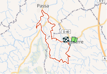
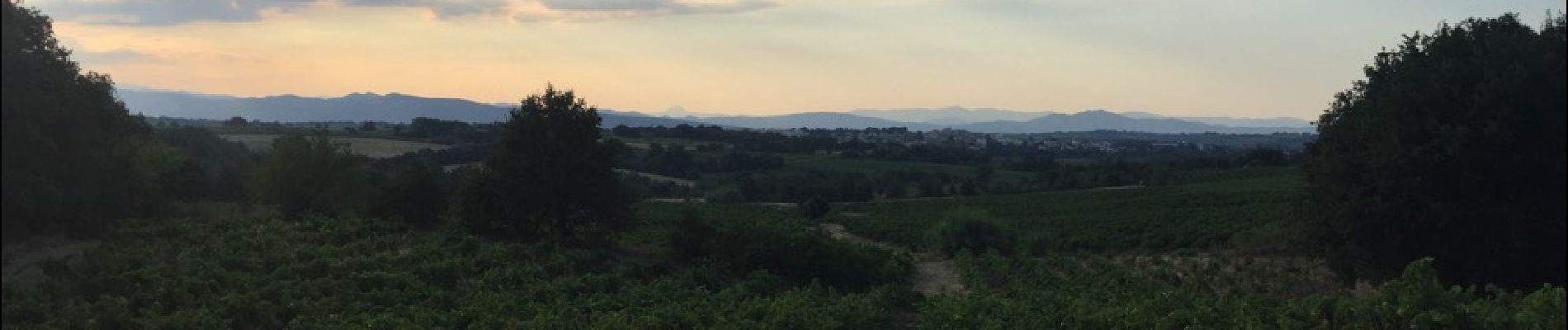
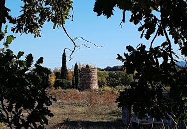
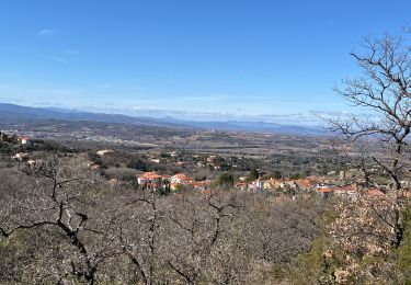
TRESSERRE 66 - parking de l'école - Costa Del Bassens - el Camp d'en Drotes - la Serra - Correc de les teuleries - panorama sur les alberes la cote banyuls dels Aspres TRESSERRE la plaine Perpignan - mas d'en Vaquer - Mas Valent - PASSA - passage à gué 1 puis dans le lit assèché du ruisseau - station de pompage et à nouveau passage à gué 2 -  l'esglesia Vello - rue des jardins - la Fontvella - chemin et Luc piste DFCI A25 - les Costes - SERRAT De la Vinya - Garriga de les Pedres - TRESSERRE - espace Planas - école François Pous

Hoogteprofiel

Foto's

Plaatsbepaling

Land:
France
Regio :
Occitanië
Departement/Provincie :
Pyrénées-Orientales
Gemeente :
Tresserre
Locatie:
Unknown
Vertrek:(Dec)
Vertrek:(UTM)
485844 ; 4712109 (31T) N.

Wandeltochten in de omgeving

Tocht Stappen Le Boulou - rando de la bataille du Boulou - Photo
Stappen
GUIDE
stef789

Stappen

Zeer moeilijk
(1)
Le Boulou, Occitanië, Pyrénées-Orientales, France
8,4 km | 10,5 km-effort
3h 27min
Ja
Tocht Stappen Montesquieu-des-Albères - MONTESQUIEU-DES-ALBERES 66 - Les Agouillous - les chemins de l'eau dans les Albères - Photo
Stappen
jeff66

Stappen

Medium
(1)
Montesquieu-des-Albères, Occitanië, Pyrénées-Orientales, France
12,7 km | 13,9 km-effort
2h 16min
Ja
Tocht Stappen Saint-Jean-Lasseille - ST-JEAN-LASSEILLE 66 - terroirs des Aspres - Photo
Stappen
jeff66

Stappen

Gemakkelijk
(1)
Saint-Jean-Lasseille, Occitanië, Pyrénées-Orientales, France
12,2 km | 14,3 km-effort
2h 6min
Ja
Tocht Stappen Fourques - Fourques  - Photo
Stappen
Fildesir

Stappen

Heel gemakkelijk
(1)
Fourques, Occitanië, Pyrénées-Orientales, France
14,2 km | 16,4 km-effort
5h 17min
Ja
Tocht Stappen Le Boulou - Bataille du Boulou (1793 - 1794) - Photo
Stappen
GUIDE
toutankhcarton

Stappen

Heel gemakkelijk
Le Boulou, Occitanië, Pyrénées-Orientales, France
10,4 km | 13,2 km-effort
1h 57min
Ja
Tocht Hybride fiets Le Boulou - Autour du Boulou (66) - Photo
Hybride fiets
GUIDE
toutankhcarton

Hybride fiets

Gemakkelijk
Le Boulou, Occitanië, Pyrénées-Orientales, France
17 km | 19,5 km-effort
1h 54min
Neen
Tocht Stappen Le Boulou - Pic Estelle (377m) - Le Boulou - Pyrénées orientales (66) - Photo
Stappen
GUIDE
toutankhcarton

Stappen

Heel gemakkelijk
Le Boulou, Occitanië, Pyrénées-Orientales, France
10,9 km | 15,9 km-effort
2h 19min
Ja
Tocht Stappen Montesquieu-des-Albères - montesquieu . puig sant cristau . prieuré Santa maria del villard  . montesquieu - Photo
Stappen
GUIDE
stef789

Stappen

Moeilijk
Montesquieu-des-Albères, Occitanië, Pyrénées-Orientales, France
15,7 km | 31 km-effort
7h 51min
Ja
Tocht Stappen Montesquieu-des-Albères - Montesquieu des Albères - Photo
Stappen
nandaf

Stappen

Medium
(1)
Montesquieu-des-Albères, Occitanië, Pyrénées-Orientales, France
7,4 km | 10,9 km-effort
2h 27min
Ja


Sluiten
Mijn abonnementen