![](/images/other/stat-length.png)
![Tocht Andere activiteiten Faido - Val Blenio - Photo](https://media.geolcdn.com/t/1900/400/ext.pjpeg?maxdim=2&url=https%3A%2F%2Fstatic1.geolcdn.com%2Fsiteimages%2Fupload%2Ffiles%2F1545311037marcheuse_200dpi.jpg)
Val Blenio
alternatives-wandern
Gebruiker
![Lengte](/images/other/stat-length.png)
Lengte
31 km
![Max. hoogte](https://static1.geolcdn.com/siteimages/upload/files/1508320355ic_sort_altitude_max_24dp.png)
Max. hoogte
1975 m
![Positief hoogteverschil](https://static1.geolcdn.com/siteimages/upload/files/1508320355ic_sort_den_pos_24dp.png)
Positief hoogteverschil
1619 m
![Km-Effort](/images/other/stat-length.png)
Km-Effort
54 km
![Min. hoogte](https://static1.geolcdn.com/siteimages/upload/files/1508320355ic_sort_altitude_min_24dp.png)
Min. hoogte
889 m
![Negatief hoogteverschil](https://static1.geolcdn.com/siteimages/upload/files/1508320355ic_sort_den_neg_24dp.png)
Negatief hoogteverschil
1850 m
![Boucle](https://static1.geolcdn.com/siteimages/upload/files/16400158638029165_repeat_loop_refresh_sync_direction_icon.png)
Boucle
Neen
Datum van aanmaak :
2014-12-10 00:00:00.0
Laatste wijziging :
2014-12-10 00:00:00.0
![Andere activiteiten](https://static1.geolcdn.com/sitytour/trail-icons/900.png)
--
Moeilijkheid : Onbekend
![Scan deze QR-code om de tocht te openen in de SityTrail-applicatie](https://capi.geolives.com/qq0zvz2zws4bq2lad0pu/sitytour/trails/44218/qr.png?size=200)
Gratisgps-wandelapplicatie
Over ons
Tocht Andere activiteiten van 31 km beschikbaar op Ticino, Distretto di Leventina, Faido. Deze tocht wordt voorgesteld door alternatives-wandern.
Beschrijving
Details siehe Wanderbeschreibung
1. und 2. Tag zusammengefasst
http://www.alternatives-wandern.ch/touren/trekking/val_blenio.htm
Plaatsbepaling
Land:
Switzerland
Regio :
Ticino
Departement/Provincie :
Distretto di Leventina
Gemeente :
Faido
Locatie:
Unknown
Vertrek:(Dec)
Vertrek:(UTM)
492442 ; 5138443 (32T) N.
Opmerkingen
Wandeltochten in de omgeving
![Tocht Te voet Faido - Chironico-Cala - Photo](https://media.geolcdn.com/t/375/260/42d6e6a4-a778-4826-b167-c510256eef88.jpeg&format=jpg&maxdim=2)
![Te voet Te voet](https://static1.geolcdn.com/sitytour/trail-icons/100.png)
Chironico-Cala
Te voet
Gemakkelijk
Faido,
Ticino,
Distretto di Leventina,
Switzerland
![](/images/other/stat-length.png)
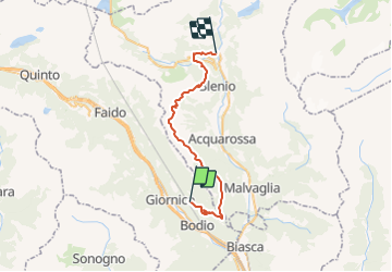
4,2 km | 11,1 km-effort
2h 31min
![](https://static1.geolcdn.com/siteimages/upload/files/16400158638029165_repeat_loop_refresh_sync_direction_icon.png)
Neen
![Tocht Te voet Personico - Faidàl-Chironico - Photo](https://media.geolcdn.com/t/375/260/42d6e6a4-a778-4826-b167-c510256eef88.jpeg&format=jpg&maxdim=2)
![Te voet Te voet](https://static1.geolcdn.com/sitytour/trail-icons/100.png)
Faidàl-Chironico
Te voet
Gemakkelijk
Personico,
Ticino,
Distretto di Leventina,
Switzerland
![](/images/other/stat-length.png)
8,3 km | 13,3 km-effort
3h 1min
![](https://static1.geolcdn.com/siteimages/upload/files/16400158638029165_repeat_loop_refresh_sync_direction_icon.png)
Neen
![Tocht Te voet Personico - Mondo-Faidàl - Photo](https://media.geolcdn.com/t/375/260/c01d9564-ecc0-4fbc-a3b1-719796504559.jpeg&format=jpg&maxdim=2)
![Te voet Te voet](https://static1.geolcdn.com/sitytour/trail-icons/100.png)
Mondo-Faidàl
Te voet
Gemakkelijk
Personico,
Ticino,
Distretto di Leventina,
Switzerland
![](/images/other/stat-length.png)
3,4 km | 9 km-effort
2h 2min
![](https://static1.geolcdn.com/siteimages/upload/files/16400158638029165_repeat_loop_refresh_sync_direction_icon.png)
Neen
![Tocht Stappen Faido - YHH135 Anzonico - Osco - Photo](https://media.geolcdn.com/t/375/260/ext.jpg?maxdim=2&url=https%3A%2F%2Fstatic1.geolcdn.com%2Fsiteimages%2Fupload%2Ffiles%2F1553511878bg_sport_marche.png)
![Stappen Stappen](https://static1.geolcdn.com/sitytour/trail-icons/101.png)
YHH135 Anzonico - Osco
Stappen
Moeilijk
Faido,
Ticino,
Distretto di Leventina,
Switzerland
![](/images/other/stat-length.png)
11,7 km | 18,9 km-effort
3h 46min
![](https://static1.geolcdn.com/siteimages/upload/files/16400158638029165_repeat_loop_refresh_sync_direction_icon.png)
Neen
![Tocht Stappen Giornico - Sommerprogramm Teil 2 Giornico - Biasca - Bellinzona - Photo](https://media.geolcdn.com/t/375/260/ext.jpg?maxdim=2&url=https%3A%2F%2Fstatic1.geolcdn.com%2Fsiteimages%2Fupload%2Ffiles%2F1553511878bg_sport_marche.png)
![Stappen Stappen](https://static1.geolcdn.com/sitytour/trail-icons/101.png)
Sommerprogramm Teil 2 Giornico - Biasca - Bellinzona
Stappen
Heel gemakkelijk
Giornico,
Ticino,
Distretto di Leventina,
Switzerland
![](/images/other/stat-length.png)
38 km | 49 km-effort
Onbekend
![](https://static1.geolcdn.com/siteimages/upload/files/16400158638029165_repeat_loop_refresh_sync_direction_icon.png)
Neen
![Tocht Stappen Giornico - Giornico - Belllinzona - Photo](https://media.geolcdn.com/t/375/260/ext.jpg?maxdim=2&url=https%3A%2F%2Fstatic1.geolcdn.com%2Fsiteimages%2Fupload%2Ffiles%2F1553511878bg_sport_marche.png)
![Stappen Stappen](https://static1.geolcdn.com/sitytour/trail-icons/101.png)
Giornico - Belllinzona
Stappen
Heel gemakkelijk
Giornico,
Ticino,
Distretto di Leventina,
Switzerland
![](/images/other/stat-length.png)
40 km | 51 km-effort
4h 17min
![](https://static1.geolcdn.com/siteimages/upload/files/16400158638029165_repeat_loop_refresh_sync_direction_icon.png)
Neen
![Tocht Stappen Faido - Leventina (Lavorgo) - Val Verzasca (Sonogno) - Photo](https://media.geolcdn.com/t/375/260/ext.jpg?maxdim=2&url=https%3A%2F%2Fstatic1.geolcdn.com%2Fsiteimages%2Fupload%2Ffiles%2F1553511878bg_sport_marche.png)
![Stappen Stappen](https://static1.geolcdn.com/sitytour/trail-icons/101.png)
Leventina (Lavorgo) - Val Verzasca (Sonogno)
Stappen
Heel gemakkelijk
Faido,
Ticino,
Distretto di Leventina,
Switzerland
![](/images/other/stat-length.png)
20 km | 42 km-effort
8h 30min
![](https://static1.geolcdn.com/siteimages/upload/files/16400158638029165_repeat_loop_refresh_sync_direction_icon.png)
Neen
![Tocht Andere activiteiten Faido - 5. Strada alta - Photo](https://media.geolcdn.com/t/375/260/ext.jpg?maxdim=2&url=https%3A%2F%2Fstatic1.geolcdn.com%2Fsiteimages%2Fupload%2Ffiles%2F1545311037marcheuse_200dpi.jpg)
![Andere activiteiten Andere activiteiten](https://static1.geolcdn.com/sitytour/trail-icons/900.png)
5. Strada alta
Andere activiteiten
Heel gemakkelijk
Faido,
Ticino,
Distretto di Leventina,
Switzerland
![](/images/other/stat-length.png)
7,7 km | 11,8 km-effort
Onbekend
![](https://static1.geolcdn.com/siteimages/upload/files/16400158638029165_repeat_loop_refresh_sync_direction_icon.png)
Neen