![](/images/other/stat-length.png)
![Tocht Andere activiteiten Glarus Süd - Guppenalp - Photo](https://media.geolcdn.com/t/1900/400/ext.pjpeg?maxdim=2&url=https%3A%2F%2Fstatic1.geolcdn.com%2Fsiteimages%2Fupload%2Ffiles%2F1545311037marcheuse_200dpi.jpg)
Guppenalp
alternatives-wandern
Gebruiker
![Lengte](/images/other/stat-length.png)
Lengte
15 km
![Max. hoogte](https://static1.geolcdn.com/siteimages/upload/files/1508320355ic_sort_altitude_max_24dp.png)
Max. hoogte
1727 m
![Positief hoogteverschil](https://static1.geolcdn.com/siteimages/upload/files/1508320355ic_sort_den_pos_24dp.png)
Positief hoogteverschil
1618 m
![Km-Effort](/images/other/stat-length.png)
Km-Effort
34 km
![Min. hoogte](https://static1.geolcdn.com/siteimages/upload/files/1508320355ic_sort_altitude_min_24dp.png)
Min. hoogte
533 m
![Negatief hoogteverschil](https://static1.geolcdn.com/siteimages/upload/files/1508320355ic_sort_den_neg_24dp.png)
Negatief hoogteverschil
891 m
![Boucle](https://static1.geolcdn.com/siteimages/upload/files/16400158638029165_repeat_loop_refresh_sync_direction_icon.png)
Boucle
Neen
Datum van aanmaak :
2014-12-10 00:00:00.0
Laatste wijziging :
2014-12-10 00:00:00.0
![Andere activiteiten](https://static1.geolcdn.com/sitytour/trail-icons/900.png)
--
Moeilijkheid : Onbekend
![Scan deze QR-code om de tocht te openen in de SityTrail-applicatie](https://capi.geolives.com/qq0zvz2zws4bq2lad0pu/sitytour/trails/44211/qr.png?size=200)
Gratisgps-wandelapplicatie
Over ons
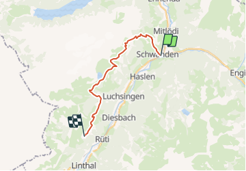
Tocht Andere activiteiten van 15 km beschikbaar op Glarus, Onbekend, Glarus Süd. Deze tocht wordt voorgesteld door alternatives-wandern.
Beschrijving
Detailbeschreibung siehe Tourenbeschreibung
http://www.alternatives-wandern.ch/touren/sommer/guppenalp.htm
Plaatsbepaling
Land:
Switzerland
Regio :
Glarus
Departement/Provincie :
Onbekend
Gemeente :
Glarus Süd
Locatie:
Unknown
Vertrek:(Dec)
Vertrek:(UTM)
505677 ; 5204533 (32T) N.
Opmerkingen
Wandeltochten in de omgeving
![Tocht Te voet Glarus Süd - Ober-Sool - fixme - Photo](https://media.geolcdn.com/t/375/260/6acf3b68-4df6-4014-921f-5cbcee916b82.jpeg&format=jpg&maxdim=2)
![Te voet Te voet](https://static1.geolcdn.com/sitytour/trail-icons/100.png)
Ober-Sool - fixme
Te voet
Gemakkelijk
Glarus Süd,
Glarus,
Onbekend,
Switzerland
![](/images/other/stat-length.png)
4,3 km | 7,2 km-effort
1h 37min
![](https://static1.geolcdn.com/siteimages/upload/files/16400158638029165_repeat_loop_refresh_sync_direction_icon.png)
Neen
![Tocht Te voet Glarus Süd - Ober-Sool - Gheist - Photo](https://media.geolcdn.com/t/375/260/6acf3b68-4df6-4014-921f-5cbcee916b82.jpeg&format=jpg&maxdim=2)
![Te voet Te voet](https://static1.geolcdn.com/sitytour/trail-icons/100.png)
Ober-Sool - Gheist
Te voet
Gemakkelijk
Glarus Süd,
Glarus,
Onbekend,
Switzerland
![](/images/other/stat-length.png)
4,6 km | 11,6 km-effort
2h 37min
![](https://static1.geolcdn.com/siteimages/upload/files/16400158638029165_repeat_loop_refresh_sync_direction_icon.png)
Neen
![Tocht Te voet Glarus - Äugsten - Passhöhe - Photo](https://media.geolcdn.com/t/375/260/64f84f56-1cff-404a-ba7d-498ea23f644b.jpeg&format=jpg&maxdim=2)
![Te voet Te voet](https://static1.geolcdn.com/sitytour/trail-icons/100.png)
Äugsten - Passhöhe
Te voet
Gemakkelijk
Glarus,
Glarus,
Onbekend,
Switzerland
![](/images/other/stat-length.png)
4,9 km | 13,5 km-effort
3h 4min
![](https://static1.geolcdn.com/siteimages/upload/files/16400158638029165_repeat_loop_refresh_sync_direction_icon.png)
Neen
![Tocht Te voet Glarus - Hinter Saggberg - Vorder Glärnisch - Photo](https://media.geolcdn.com/t/375/260/dev_8889af8a-9531-40dc-80ec-d7aa9a2a529c.jpeg&format=jpg&maxdim=2)
![Te voet Te voet](https://static1.geolcdn.com/sitytour/trail-icons/100.png)
Hinter Saggberg - Vorder Glärnisch
Te voet
Gemakkelijk
Glarus,
Glarus,
Onbekend,
Switzerland
![](/images/other/stat-length.png)
4,6 km | 17,4 km-effort
3h 57min
![](https://static1.geolcdn.com/siteimages/upload/files/16400158638029165_repeat_loop_refresh_sync_direction_icon.png)
Neen
![Tocht Te voet Glarus Süd - Chärpfbrugg Rundweg - Photo](https://media.geolcdn.com/t/375/260/b977a8ca-a0db-47ae-bd1e-286d5679c384.jpeg&format=jpg&maxdim=2)
![Te voet Te voet](https://static1.geolcdn.com/sitytour/trail-icons/100.png)
Chärpfbrugg Rundweg
Te voet
Gemakkelijk
Glarus Süd,
Glarus,
Onbekend,
Switzerland
![](/images/other/stat-length.png)
6,7 km | 11,7 km-effort
2h 40min
![](https://static1.geolcdn.com/siteimages/upload/files/16400158638029165_repeat_loop_refresh_sync_direction_icon.png)
Ja
![Tocht Te voet Glarus Süd - Mettlen - Soolsteg - Photo](https://media.geolcdn.com/t/375/260/bd08ec3f-0540-4e6e-a5fe-27561de9e2bf.jpeg&format=jpg&maxdim=2)
![Te voet Te voet](https://static1.geolcdn.com/sitytour/trail-icons/100.png)
Mettlen - Soolsteg
Te voet
Gemakkelijk
Glarus Süd,
Glarus,
Onbekend,
Switzerland
![](/images/other/stat-length.png)
3,3 km | 4,4 km-effort
1h 0min
![](https://static1.geolcdn.com/siteimages/upload/files/16400158638029165_repeat_loop_refresh_sync_direction_icon.png)
Neen
![Tocht Te voet Glarus Süd - Schwändi Schulhaus-Yenstock - Photo](https://media.geolcdn.com/t/375/260/b0a658d8-8adb-4e8f-b92f-0e4e6f8cd258.jpeg&format=jpg&maxdim=2)
![Te voet Te voet](https://static1.geolcdn.com/sitytour/trail-icons/100.png)
Schwändi Schulhaus-Yenstock
Te voet
Medium
Glarus Süd,
Glarus,
Onbekend,
Switzerland
![](/images/other/stat-length.png)
7 km | 21 km-effort
4h 42min
![](https://static1.geolcdn.com/siteimages/upload/files/16400158638029165_repeat_loop_refresh_sync_direction_icon.png)
Neen
![Tocht Stappen Glarus Süd - test_murgl - Photo](https://media.geolcdn.com/t/375/260/ext.jpg?maxdim=2&url=https%3A%2F%2Fstatic1.geolcdn.com%2Fsiteimages%2Fupload%2Ffiles%2F1553511878bg_sport_marche.png)
![Stappen Stappen](https://static1.geolcdn.com/sitytour/trail-icons/101.png)
test_murgl
Stappen
Heel gemakkelijk
Glarus Süd,
Glarus,
Onbekend,
Switzerland
![](/images/other/stat-length.png)
48 km | 125 km-effort
Onbekend
![](https://static1.geolcdn.com/siteimages/upload/files/16400158638029165_repeat_loop_refresh_sync_direction_icon.png)
Neen
![Tocht Andere activiteiten Glarus - Gufelstock - Photo](https://media.geolcdn.com/t/375/260/ext.jpg?maxdim=2&url=https%3A%2F%2Fstatic1.geolcdn.com%2Fsiteimages%2Fupload%2Ffiles%2F1545311037marcheuse_200dpi.jpg)
![Andere activiteiten Andere activiteiten](https://static1.geolcdn.com/sitytour/trail-icons/900.png)
Gufelstock
Andere activiteiten
Heel gemakkelijk
Glarus,
Glarus,
Onbekend,
Switzerland
![](/images/other/stat-length.png)
19,4 km | 49 km-effort
Onbekend
![](https://static1.geolcdn.com/siteimages/upload/files/16400158638029165_repeat_loop_refresh_sync_direction_icon.png)
Ja