Tocht Stappen Cauterets - Petit_Vignemale - Photo
 lebretonjd
lebretonjd

Gebruiker

© OpenStreetMap contributors
Lengte
Lengte
36 km
Max. hoogte
Max. hoogte
3014 m
Positief hoogteverschil
2449 m
Km-Effort
Km-Effort  
68 km
Min. hoogte
Min. hoogte
1037 m
Negatief hoogteverschil
2451 m
Boucle
Boucle
Ja
Datum van aanmaak :
2015-07-05 00:00:00.0
Laatste wijziging :
2015-07-05 00:00:00.0

(0 Bericht)

Stappen
Stappen
13h33
Moeilijkheid : Moeilijk

Scan deze QR-code om de tocht te openen in de SityTrail-applicatie

Gratisgps-wandelapplicatie

Logo SityTrail SityTrail

IGN / Geografische instituten

SityTrail uit de App Store downloaden SityTrail uit Google Play downloaden

Logo SityTrail SityTrail World

De wereld gaat voor u open

SityTrail uit de App Store downloaden SityTrail uit Google Play downloaden SityTrail op Huawei AppGallery downloaden

Over ons

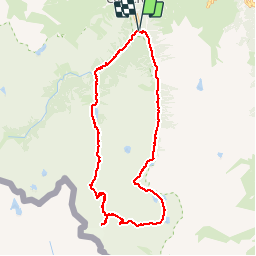
Tocht Stappen van 36 km beschikbaar op Occitanië, Hautes-Pyrénées, Cauterets. Deze tocht wordt voorgesteld door lebretonjd.

Beschrijving

circuit par les Oulettes de Gaube

Hoogteprofiel

POI's

POI Cauterets - La Raillere - Photo
lebretonjd
CAUTERETS 
POI Cauterets - Cascade du Ceriset - Photo
lebretonjd
POI Cauterets - Cascade du Pas de l Ours - Photo
lebretonjd
POI Cauterets - Pont d Espagne - Photo
lebretonjd
CAUTERETS 
POI Cauterets - Lac de Gaube - Photo
lebretonjd
CAUTERETS 
POI Cauterets - Cabane du Pinet - Photo
lebretonjd
CAUTERETS 
POI Cauterets - Refuge Houlette de Gaube - Photo
lebretonjd
POI Cauterets - Bifurcation Col d Araille - Photo
lebretonjd
POI Cauterets - Hourquette d Ossoue - Photo
lebretonjd
POI Cauterets - Petit Vignamele - Photo
lebretonjd
CAUTERETS 
POI Gavarnie-Gèdre - Refuge de Baysselance - Photo
lebretonjd
GAVARNIE-GÈDRE 
POI Gavarnie-Gèdre - Grottes Bellevue - Photo
lebretonjd
GAVARNIE-GÈDRE 
POI Gavarnie-Gèdre - Lac des Gentianes - Photo
lebretonjd
GAVARNIE-GÈDRE 
POI Gavarnie-Gèdre - Col des Gentianes - Photo
lebretonjd
GAVARNIE-GÈDRE 
POI Cauterets - Petit lac du col - Photo
lebretonjd
CAUTERETS 
POI Cauterets - Lac Couy - Photo
lebretonjd
CAUTERETS 
POI Cauterets - Limite parc national - Photo
lebretonjd
POI Cauterets - Refuge d Estom - Photo
lebretonjd
CAUTERETS 
POI Cauterets - La Fruitiere - Photo
lebretonjd
CAUTERETS 
POI Cauterets - Bifurcation - descente vers la Raillere - Photo
lebretonjd

Plaatsbepaling

Land:
France
Regio :
Occitanië
Departement/Provincie :
Hautes-Pyrénées
Gemeente :
Cauterets
Locatie:
Unknown
Vertrek:(Dec)
Vertrek:(UTM)
736108 ; 4750795 (30T) N.

Wandeltochten in de omgeving

Tocht Stappen Cauterets - Lac d'Estom - Photo
Stappen
Philindy26

Stappen

Medium
(1)
Cauterets, Occitanië, Hautes-Pyrénées, France
11,4 km | 17,5 km-effort
3h 30min
Ja
Tocht Stappen Cauterets - contrefort de Cauterets - Photo
Stappen
christian33

Stappen

Medium
(1)
Cauterets, Occitanië, Hautes-Pyrénées, France
13,7 km | 21 km-effort
4h 21min
Ja
Tocht Stappen Grust - PIC DE VISCOS - Photo
Stappen
PVERTICAL

Stappen

Medium
(1)
Grust, Occitanië, Hautes-Pyrénées, France
10,5 km | 18,4 km-effort
4h 7min
Ja
Tocht Stappen Cauterets - Le Cabaliros - Photo
Stappen
tracegps

Stappen

Moeilijk
(1)
Cauterets, Occitanië, Hautes-Pyrénées, France
14,5 km | 29 km-effort
5h 0min
Ja
Tocht Stappen Cauterets - promenade Russell - Photo
Stappen
pffrench

Stappen

Heel gemakkelijk
(1)
Cauterets, Occitanië, Hautes-Pyrénées, France
11,9 km | 21 km-effort
5h 46min
Ja
Tocht Stappen Cauterets - Chemin des cascades - Photo
Stappen
herve.feurprier

Stappen

Gemakkelijk
(1)
Cauterets, Occitanië, Hautes-Pyrénées, France
8 km | 12,6 km-effort
2h 30min
Neen
Tocht Stappen Cauterets - 2022-12-31 Marche Refuge du Clot vers Refuge Wallon - Photo
Stappen
GUIDE
holtzv

Stappen

Moeilijk
Cauterets, Occitanië, Hautes-Pyrénées, France
17,3 km | 34 km-effort
7h 46min
Neen
Tocht Stappen Cauterets - CAUTERETS Le chemin des pères G3 le 14/10/2022
Stappen
GUIDE
marmotte65

Stappen

Medium
Cauterets, Occitanië, Hautes-Pyrénées, France
9,4 km | 15,3 km-effort
3h 5min
Ja
Tocht Stappen Cauterets - Pic d'Estibe Aute - Photo
Stappen
tracegps

Stappen

Zeer moeilijk
(1)
Cauterets, Occitanië, Hautes-Pyrénées, France
17,2 km | 36 km-effort
7h 0min
Ja


Sluiten
Mijn abonnementen