![](/images/other/stat-length.png)
![Tocht Te voet Loška Dolina - Pot prijateljstva Snežnik-Snježnik - Photo](https://media.geolcdn.com/t/1900/400/454ce306-fc2c-43e2-8038-3237620763ce.jpeg&format=pjpeg&maxdim=2)
Pot prijateljstva Snežnik-Snježnik
SityTrail - itinéraires balisés pédestres
Tous les sentiers balisés d’Europe GUIDE+
![Lengte](/images/other/stat-length.png)
Lengte
28 km
![Max. hoogte](https://static1.geolcdn.com/siteimages/upload/files/1508320355ic_sort_altitude_max_24dp.png)
Max. hoogte
1771 m
![Positief hoogteverschil](https://static1.geolcdn.com/siteimages/upload/files/1508320355ic_sort_den_pos_24dp.png)
Positief hoogteverschil
832 m
![Km-Effort](/images/other/stat-length.png)
Km-Effort
40 km
![Min. hoogte](https://static1.geolcdn.com/siteimages/upload/files/1508320355ic_sort_altitude_min_24dp.png)
Min. hoogte
1155 m
![Negatief hoogteverschil](https://static1.geolcdn.com/siteimages/upload/files/1508320355ic_sort_den_neg_24dp.png)
Negatief hoogteverschil
1127 m
![Boucle](https://static1.geolcdn.com/siteimages/upload/files/16400158638029165_repeat_loop_refresh_sync_direction_icon.png)
Boucle
Neen
Markering
Datum van aanmaak :
2025-02-07 21:19:06.623
Laatste wijziging :
2025-02-07 21:19:06.623
![Te voet](https://static1.geolcdn.com/sitytour/trail-icons/100.png)
9h04
Moeilijkheid : Moeilijk
![Scan deze QR-code om de tocht te openen in de SityTrail-applicatie](https://capi.geolives.com/qq0zvz2zws4bq2lad0pu/sitytour/trails/4346791/qr.png?size=200)
Gratisgps-wandelapplicatie
Over ons
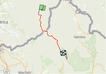
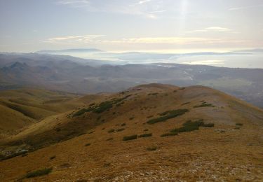
Tocht Te voet van 28 km beschikbaar op Onbekend, Onbekend, Loška Dolina. Deze tocht wordt voorgesteld door SityTrail - itinéraires balisés pédestres.
Beschrijving
Tocht aangemaakt door Planinsko društvo Snežnik Ilirska Bistrica, PD Platak Rijeka.
Plaatsbepaling
Land:
Slovenia
Regio :
Onbekend
Departement/Provincie :
Onbekend
Gemeente :
Loška Dolina
Locatie:
Unknown
Vertrek:(Dec)
Vertrek:(UTM)
456888 ; 5048408 (33T) N.
Opmerkingen
Wandeltochten in de omgeving
![Tocht Te voet - Saršoni - Studena - Photo](https://media.geolcdn.com/t/375/260/dbbd9bec-d8f7-4124-bf49-f7a77d949ce1.jpeg&format=jpg&maxdim=2)
![Te voet Te voet](https://static1.geolcdn.com/sitytour/trail-icons/100.png)
Saršoni - Studena
Te voet
Gemakkelijk
,
Onbekend,
Primorsko-goranska županija,
Croatia
![](/images/other/stat-length.png)
3,8 km | 4,4 km-effort
59min
![](https://static1.geolcdn.com/siteimages/upload/files/16400158638029165_repeat_loop_refresh_sync_direction_icon.png)
Neen
![Tocht Te voet - Gornje Jelenje - Fužine - Photo](https://media.geolcdn.com/t/375/260/bc446bdd-3cfe-45c0-94f3-3ba2d4e990b4.jpeg&format=jpg&maxdim=2)
![Te voet Te voet](https://static1.geolcdn.com/sitytour/trail-icons/100.png)
Gornje Jelenje - Fužine
Te voet
Medium
,
Onbekend,
Primorsko-goranska županija,
Croatia
![](/images/other/stat-length.png)
18,4 km | 29 km-effort
6h 36min
![](https://static1.geolcdn.com/siteimages/upload/files/16400158638029165_repeat_loop_refresh_sync_direction_icon.png)
Neen
![Tocht Te voet - Nacionalni park Risnjak - Photo](https://media.geolcdn.com/t/375/260/d7f43ced-7746-4c3c-aa97-9c953327d62b.jpeg&format=jpg&maxdim=2)
![Te voet Te voet](https://static1.geolcdn.com/sitytour/trail-icons/100.png)
Nacionalni park Risnjak
Te voet
Moeilijk
,
Onbekend,
Primorsko-goranska županija,
Croatia
![](/images/other/stat-length.png)
24 km | 40 km-effort
9h 1min
![](https://static1.geolcdn.com/siteimages/upload/files/16400158638029165_repeat_loop_refresh_sync_direction_icon.png)
Neen
![Tocht Te voet - Tršće - Sveta gora - Izvor Kupe - Crni Lug - Photo](https://media.geolcdn.com/t/375/260/60013492-baa6-4369-bcba-b910bef47edc.jpeg&format=jpg&maxdim=2)
![Te voet Te voet](https://static1.geolcdn.com/sitytour/trail-icons/100.png)
Tršće - Sveta gora - Izvor Kupe - Crni Lug
Te voet
Medium
,
Onbekend,
Primorsko-goranska županija,
Croatia
![](/images/other/stat-length.png)
15,3 km | 24 km-effort
5h 25min
![](https://static1.geolcdn.com/siteimages/upload/files/16400158638029165_repeat_loop_refresh_sync_direction_icon.png)
Neen
![Tocht Te voet - Prezid - Čabar - Tršće - Photo](https://media.geolcdn.com/t/375/260/63396e8a-0219-4975-8a92-2dc12ba77793.jpeg&format=jpg&maxdim=2)
![Te voet Te voet](https://static1.geolcdn.com/sitytour/trail-icons/100.png)
Prezid - Čabar - Tršće
Te voet
Gemakkelijk
,
Onbekend,
Primorsko-goranska županija,
Croatia
![](/images/other/stat-length.png)
4,9 km | 7,1 km-effort
1h 36min
![](https://static1.geolcdn.com/siteimages/upload/files/16400158638029165_repeat_loop_refresh_sync_direction_icon.png)
Neen
![Tocht Te voet - OH 15 - Photo](https://media.geolcdn.com/t/375/260/9b4194d2-19d6-4583-806e-0f711ce103ee.jpeg&format=jpg&maxdim=2)
![Te voet Te voet](https://static1.geolcdn.com/sitytour/trail-icons/100.png)
OH 15
Te voet
Gemakkelijk
,
Onbekend,
Primorsko-goranska županija,
Croatia
![](/images/other/stat-length.png)
4,7 km | 7,5 km-effort
1h 41min
![](https://static1.geolcdn.com/siteimages/upload/files/16400158638029165_repeat_loop_refresh_sync_direction_icon.png)
Neen
![Tocht Te voet - Obilježen planinarskom stazom - Photo](https://media.geolcdn.com/t/375/260/dbbd9bec-d8f7-4124-bf49-f7a77d949ce1.jpeg&format=jpg&maxdim=2)
![Te voet Te voet](https://static1.geolcdn.com/sitytour/trail-icons/100.png)
Obilježen planinarskom stazom
Te voet
Gemakkelijk
,
Onbekend,
Primorsko-goranska županija,
Croatia
![](/images/other/stat-length.png)
5,4 km | 6,6 km-effort
1h 29min
![](https://static1.geolcdn.com/siteimages/upload/files/16400158638029165_repeat_loop_refresh_sync_direction_icon.png)
Neen
![Tocht Te voet - Potkilvac - Zapodi-Halić - Photo](https://media.geolcdn.com/t/375/260/d3d063af-e7e5-4024-b9b5-6f97f93004ac.jpeg&format=jpg&maxdim=2)
![Te voet Te voet](https://static1.geolcdn.com/sitytour/trail-icons/100.png)
Potkilvac - Zapodi-Halić
Te voet
Gemakkelijk
,
Onbekend,
Primorsko-goranska županija,
Croatia
![](/images/other/stat-length.png)
4,1 km | 6,6 km-effort
1h 29min
![](https://static1.geolcdn.com/siteimages/upload/files/16400158638029165_repeat_loop_refresh_sync_direction_icon.png)
Neen
![Tocht Te voet - Potkilvac - Mudnaj dol - Gorničko - Halić - Photo](https://media.geolcdn.com/t/375/260/dea22dc6-3eb5-40f6-98dd-032c98fe4d60.jpeg&format=jpg&maxdim=2)
![Te voet Te voet](https://static1.geolcdn.com/sitytour/trail-icons/100.png)
Potkilvac - Mudnaj dol - Gorničko - Halić
Te voet
Gemakkelijk
,
Onbekend,
Primorsko-goranska županija,
Croatia
![](/images/other/stat-length.png)
5,9 km | 8,2 km-effort
1h 52min
![](https://static1.geolcdn.com/siteimages/upload/files/16400158638029165_repeat_loop_refresh_sync_direction_icon.png)
Neen