Tocht Te voet Loučná pod Klínovcem - NS Loučná pod Klínovcem - Photo

Tous les sentiers balisés d’Europe GUIDE+

© OpenStreetMap contributors
Lengte
Lengte
17,1 km
Max. hoogte
Max. hoogte
1046 m
Positief hoogteverschil
423 m
Km-Effort
Km-Effort  
23 km
Min. hoogte
Min. hoogte
859 m
Negatief hoogteverschil
425 m
Boucle
Boucle
Ja
Markering
Markering
Datum van aanmaak :
2025-02-07 20:58:01.84
Laatste wijziging :
2025-02-07 20:58:01.84

(0 Bericht)

Te voet
Te voet
5h10
Moeilijkheid : Medium

Scan deze QR-code om de tocht te openen in de SityTrail-applicatie

Gratisgps-wandelapplicatie

Logo SityTrail SityTrail

IGN / Geografische instituten

SityTrail uit de App Store downloaden SityTrail uit Google Play downloaden

Logo SityTrail SityTrail World

De wereld gaat voor u open

SityTrail uit de App Store downloaden SityTrail uit Google Play downloaden SityTrail op Huawei AppGallery downloaden

Over ons

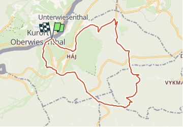
Tocht Te voet van 17,1 km beschikbaar op Noordwest, Ústecký kraj, Loučná pod Klínovcem. Deze tocht wordt voorgesteld door SityTrail - itinéraires balisés pédestres.

Hoogteprofiel

Foto's

Plaatsbepaling

Land:
Czech Republic
Regio :
Noordwest
Departement/Provincie :
Ústecký kraj
Gemeente :
Loučná pod Klínovcem
Locatie:
Unknown
Vertrek:(UTM)
356548 ; 5587136 (33U) N.

Wandeltochten in de omgeving

Tocht Te voet Boží Dar - naučná stezka Božídarské rašeliniště - Photo
Te voet
GUIDE+

Te voet

Gemakkelijk
Boží Dar, Noordwest, Regio Karlsbad, Czech Republic
3,3 km | 3,9 km-effort
53min
Ja
Tocht Te voet Jáchymov - [Ž] Klínovec - Radošov - Photo
Te voet
GUIDE+

Te voet

Medium
Jáchymov, Noordwest, Regio Karlsbad, Czech Republic
18,9 km | 24 km-effort
5h 26min
Neen
Tocht Te voet Jáchymov - naučná stezka Montánní krajina Krušných hor - Photo
Te voet
GUIDE+

Te voet

Gemakkelijk
Jáchymov, Noordwest, Regio Karlsbad, Czech Republic
10,7 km | 15,6 km-effort
3h 32min
Ja
Tocht Te voet Oberwiesenthal - Ww Bächelhütte - Rittersgrün - Pöhla - Photo
Te voet
GUIDE+

Te voet

Gemakkelijk
Oberwiesenthal, Saksen, Erzgebirgskreis, Germany
14,9 km | 18 km-effort
4h 6min
Neen
Tocht Te voet Oberwiesenthal - Ww Rotes Vorwerk - Pförtelstraße - Photo
Te voet
GUIDE+

Te voet

Gemakkelijk
Oberwiesenthal, Saksen, Erzgebirgskreis, Germany
3,9 km | 5,2 km-effort
1h 10min
Neen
Tocht Te voet Oberwiesenthal - Eric-Frenzel-Tour - Photo
Te voet
GUIDE+

Te voet

Gemakkelijk
Oberwiesenthal, Saksen, Erzgebirgskreis, Germany
3,5 km | 5,2 km-effort
1h 11min
Ja


Sluiten
Mijn abonnementen