


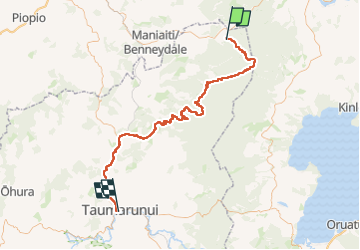
Te Araroa - 03 Waikato - m Pureora Forest Park to Taumarunui

SityTrail - itinéraires balisés pédestres
Tous les sentiers balisés d’Europe GUIDE+

Lengte
102 km

Max. hoogte
1000 m

Positief hoogteverschil
1681 m
Km-Effort
125 km

Min. hoogte
168 m

Negatief hoogteverschil
2088 m
Boucle
Neen

Markering
Datum van aanmaak :
2025-02-07 20:05:23.001
Laatste wijziging :
2025-02-07 20:05:23.001
28h29
Moeilijkheid : Zeer moeilijk

Gratisgps-wandelapplicatie
 SityTrail
IGN / Geografische instituten
SityTrail World
De wereld gaat voor u open
Over ons
Tocht Te voet van 102 km beschikbaar op Manawatū-Whanganui, Waitomo District. Deze tocht wordt voorgesteld door SityTrail - itinéraires balisés pédestres.
Plaatsbepaling
Land:
New Zealand
Regio :
Manawatū-Whanganui
Departement/Provincie :
Waitomo District
Gemeente :
Unknown
Locatie:
Unknown
Vertrek:(Dec)
Vertrek:(UTM)
374195 ; 5736210 (60H) Z.
Opmerkingen
Wandeltochten in de omgeving