![](/images/other/stat-length.png)
![Tocht Te voet Unknown - Hutt Road shared path - Wellington to Petone - Photo](https://media.geolcdn.com/t/1900/400/ext.pjpeg?maxdim=2&url=https%3A%2F%2Fstatic1.geolcdn.com%2Fsiteimages%2Fupload%2Ffiles%2F1545311037marcheuse_200dpi.jpg)
Hutt Road shared path - Wellington to Petone
SityTrail - itinéraires balisés pédestres
Tous les sentiers balisés d’Europe GUIDE+
![Lengte](/images/other/stat-length.png)
Lengte
10,8 km
![Max. hoogte](https://static1.geolcdn.com/siteimages/upload/files/1508320355ic_sort_altitude_max_24dp.png)
Max. hoogte
23 m
![Positief hoogteverschil](https://static1.geolcdn.com/siteimages/upload/files/1508320355ic_sort_den_pos_24dp.png)
Positief hoogteverschil
85 m
![Km-Effort](/images/other/stat-length.png)
Km-Effort
12 km
![Min. hoogte](https://static1.geolcdn.com/siteimages/upload/files/1508320355ic_sort_altitude_min_24dp.png)
Min. hoogte
0 m
![Negatief hoogteverschil](https://static1.geolcdn.com/siteimages/upload/files/1508320355ic_sort_den_neg_24dp.png)
Negatief hoogteverschil
87 m
![Boucle](https://static1.geolcdn.com/siteimages/upload/files/16400158638029165_repeat_loop_refresh_sync_direction_icon.png)
Boucle
Neen
Markering
Datum van aanmaak :
2025-02-07 18:18:28.837
Laatste wijziging :
2025-02-07 18:18:28.837
![Te voet](https://static1.geolcdn.com/sitytour/trail-icons/100.png)
2h43
Moeilijkheid : Gemakkelijk
![Scan deze QR-code om de tocht te openen in de SityTrail-applicatie](https://capi.geolives.com/qq0zvz2zws4bq2lad0pu/sitytour/trails/4346504/qr.png?size=200)
Gratisgps-wandelapplicatie
Over ons
Tocht Te voet van 10,8 km beschikbaar op Wellington, Wellington City. Deze tocht wordt voorgesteld door SityTrail - itinéraires balisés pédestres.
Beschrijving
Tocht aangemaakt door assumed Wellington City Council from Aotea Quay to Ngauranga and NZTA (for SH2) on to Petone.
Plaatsbepaling
Land:
New Zealand
Regio :
Wellington
Departement/Provincie :
Wellington City
Gemeente :
Unknown
Locatie:
Unknown
Vertrek:(Dec)
Vertrek:(UTM)
314114 ; 5427879 (60G) Z.
Opmerkingen
Wandeltochten in de omgeving
![Tocht Te voet - Polhill Reserve loop shared way - Photo](https://media.geolcdn.com/t/375/260/b952bd82-4563-49c0-9b8a-a044e5fd1fb1.jpeg&format=jpg&maxdim=2)
![Te voet Te voet](https://static1.geolcdn.com/sitytour/trail-icons/100.png)
Polhill Reserve loop shared way
Te voet
Gemakkelijk
,
Wellington,
Wellington City,
New Zealand
![](/images/other/stat-length.png)
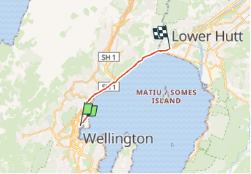
6,4 km | 9,2 km-effort
2h 5min
![](https://static1.geolcdn.com/siteimages/upload/files/16400158638029165_repeat_loop_refresh_sync_direction_icon.png)
Ja
![Tocht Te voet - Southern Walkway - Photo](https://media.geolcdn.com/t/375/260/01b27489-2bc2-4f34-a02b-eca2f1b9ae46.jpeg&format=jpg&maxdim=2)
![Te voet Te voet](https://static1.geolcdn.com/sitytour/trail-icons/100.png)
Southern Walkway
Te voet
Gemakkelijk
,
Wellington,
Wellington City,
New Zealand
![](/images/other/stat-length.png)
9,9 km | 14,6 km-effort
3h 19min
![](https://static1.geolcdn.com/siteimages/upload/files/16400158638029165_repeat_loop_refresh_sync_direction_icon.png)
Neen
![Tocht Te voet - Te Araroa - 06 Wellington - f Lambton Quay, Wellington to Shorland Park, Island Bay - Photo](https://media.geolcdn.com/t/375/260/c027d961-c23f-4cbb-8548-c43eb304f969.jpeg&format=jpg&maxdim=2)
![Te voet Te voet](https://static1.geolcdn.com/sitytour/trail-icons/100.png)
Te Araroa - 06 Wellington - f Lambton Quay, Wellington to Shorland Park, Isla...
Te voet
Gemakkelijk
,
Wellington,
Wellington City,
New Zealand
![](/images/other/stat-length.png)
13,6 km | 19,1 km-effort
4h 20min
![](https://static1.geolcdn.com/siteimages/upload/files/16400158638029165_repeat_loop_refresh_sync_direction_icon.png)
Neen
![Tocht Te voet - City to Sea Walkway - Photo](https://media.geolcdn.com/t/375/260/01b27489-2bc2-4f34-a02b-eca2f1b9ae46.jpeg&format=jpg&maxdim=2)
![Te voet Te voet](https://static1.geolcdn.com/sitytour/trail-icons/100.png)
City to Sea Walkway
Te voet
Medium
,
Wellington,
Wellington City,
New Zealand
![](/images/other/stat-length.png)
13,9 km | 21 km-effort
4h 43min
![](https://static1.geolcdn.com/siteimages/upload/files/16400158638029165_repeat_loop_refresh_sync_direction_icon.png)
Neen