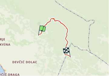
![](/images/other/stat-length.png)
![Tocht Te voet Unknown - Južni Velebit II - do Stapa - Photo](https://media.geolcdn.com/t/1900/400/dec1b585-9c95-440b-9afc-bdefe2605220.jpeg&format=pjpeg&maxdim=2)
Južni Velebit II - do Stapa
SityTrail - itinéraires balisés pédestres
Tous les sentiers balisés d’Europe GUIDE+
![Lengte](/images/other/stat-length.png)
![Max. hoogte](https://static1.geolcdn.com/siteimages/upload/files/1508320355ic_sort_altitude_max_24dp.png)
![Positief hoogteverschil](https://static1.geolcdn.com/siteimages/upload/files/1508320355ic_sort_den_pos_24dp.png)
![Km-Effort](/images/other/stat-length.png)
![Min. hoogte](https://static1.geolcdn.com/siteimages/upload/files/1508320355ic_sort_altitude_min_24dp.png)
![Negatief hoogteverschil](https://static1.geolcdn.com/siteimages/upload/files/1508320355ic_sort_den_neg_24dp.png)
![Boucle](https://static1.geolcdn.com/siteimages/upload/files/16400158638029165_repeat_loop_refresh_sync_direction_icon.png)
![Te voet](https://static1.geolcdn.com/sitytour/trail-icons/100.png)
2h46
Moeilijkheid : Gemakkelijk
![Scan deze QR-code om de tocht te openen in de SityTrail-applicatie](https://capi.geolives.com/qq0zvz2zws4bq2lad0pu/sitytour/trails/4346143/qr.png?size=200)
Gratisgps-wandelapplicatie
Over ons
Tocht Te voet van 8,2 km beschikbaar op Onbekend, Ličko-senjska županija. Deze tocht wordt voorgesteld door SityTrail - itinéraires balisés pédestres.
Beschrijving
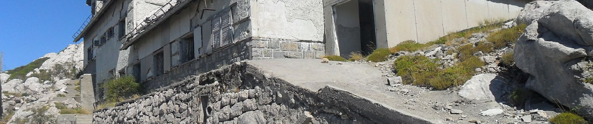
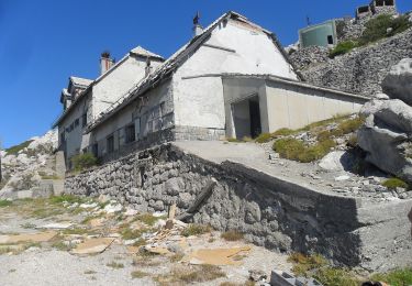
The section from Šugarska duliba to Stap offers genuine wilderness, with forest calm and tranquility dominating this wide area. The only longitudinal trail in this area is the Velebit Hiking Trail. This section requires 5 hours of hiking.
Website: https://trail.viadinarica.com/tour/hiking/15966597/
Plaatsbepaling
Opmerkingen
Wandeltochten in de omgeving
![Tocht Te voet - Stap - Jelova Ruja - Photo](https://media.geolcdn.com/t/375/260/dec1b585-9c95-440b-9afc-bdefe2605220.jpeg&format=jpg&maxdim=2)
![Te voet Te voet](https://static1.geolcdn.com/sitytour/trail-icons/100.png)
Te voet
![](/images/other/stat-length.png)
![](https://static1.geolcdn.com/siteimages/upload/files/16400158638029165_repeat_loop_refresh_sync_direction_icon.png)
![Tocht Te voet - Jelova Ruja - Jandrina poljana - Photo](https://media.geolcdn.com/t/375/260/fae9f49c-d8f4-4ef3-adb5-5b866626d596.jpeg&format=jpg&maxdim=2)
![Te voet Te voet](https://static1.geolcdn.com/sitytour/trail-icons/100.png)
Te voet
![](/images/other/stat-length.png)
![](https://static1.geolcdn.com/siteimages/upload/files/16400158638029165_repeat_loop_refresh_sync_direction_icon.png)
![Tocht Te voet - Šugarska staza - Photo](https://media.geolcdn.com/t/375/260/0db3540d-6872-477d-a1e1-486c1b1204db.jpeg&format=jpg&maxdim=2)
![Te voet Te voet](https://static1.geolcdn.com/sitytour/trail-icons/100.png)
Te voet
![](/images/other/stat-length.png)
![](https://static1.geolcdn.com/siteimages/upload/files/16400158638029165_repeat_loop_refresh_sync_direction_icon.png)
![Tocht Te voet - Križac - Šugarska duliba - Photo](https://media.geolcdn.com/t/375/260/c7961c24-4930-4b23-8309-b52999876b7a.jpeg&format=jpg&maxdim=2)
![Te voet Te voet](https://static1.geolcdn.com/sitytour/trail-icons/100.png)
Te voet
![](/images/other/stat-length.png)
![](https://static1.geolcdn.com/siteimages/upload/files/16400158638029165_repeat_loop_refresh_sync_direction_icon.png)
![Tocht Te voet - Kruščica - Stap - Photo](https://media.geolcdn.com/t/375/260/cfffeff4-44e6-4508-a23e-83578ab1cdc9.jpeg&format=jpg&maxdim=2)
![Te voet Te voet](https://static1.geolcdn.com/sitytour/trail-icons/100.png)
Te voet
![](/images/other/stat-length.png)
![](https://static1.geolcdn.com/siteimages/upload/files/16400158638029165_repeat_loop_refresh_sync_direction_icon.png)
![Tocht Te voet - Brušane - Ripište - Photo](https://media.geolcdn.com/t/375/260/b12f2aaa-8345-4da9-96d6-84b618709aa1.jpeg&format=jpg&maxdim=2)
![Te voet Te voet](https://static1.geolcdn.com/sitytour/trail-icons/100.png)
Te voet
![](/images/other/stat-length.png)
![](https://static1.geolcdn.com/siteimages/upload/files/16400158638029165_repeat_loop_refresh_sync_direction_icon.png)
![Tocht Te voet - Stap - odvojak za Panos - Photo](https://media.geolcdn.com/t/375/260/ext.jpg?maxdim=2&url=https%3A%2F%2Fstatic1.geolcdn.com%2Fsiteimages%2Fupload%2Ffiles%2F1545311037marcheuse_200dpi.jpg)
![Te voet Te voet](https://static1.geolcdn.com/sitytour/trail-icons/100.png)
Te voet
![](/images/other/stat-length.png)
![](https://static1.geolcdn.com/siteimages/upload/files/16400158638029165_repeat_loop_refresh_sync_direction_icon.png)
![Tocht Te voet - Stap - Veliko Rujno - Photo](https://media.geolcdn.com/t/375/260/ext.jpg?maxdim=2&url=https%3A%2F%2Fstatic1.geolcdn.com%2Fsiteimages%2Fupload%2Ffiles%2F1545311037marcheuse_200dpi.jpg)
![Te voet Te voet](https://static1.geolcdn.com/sitytour/trail-icons/100.png)
Te voet
![](/images/other/stat-length.png)
![](https://static1.geolcdn.com/siteimages/upload/files/16400158638029165_repeat_loop_refresh_sync_direction_icon.png)