Tocht Te voet Unknown - Dabri i Dabarski kukovi - Photo

Tous les sentiers balisés d’Europe GUIDE+

© OpenStreetMap contributors
Lengte
Lengte
11,8 km
Max. hoogte
Max. hoogte
1140 m
Positief hoogteverschil
375 m
Km-Effort
Km-Effort  
17,5 km
Min. hoogte
Min. hoogte
725 m
Negatief hoogteverschil
594 m
Boucle
Boucle
Neen
Markering
Markering
Datum van aanmaak :
2025-02-07 16:08:34.961
Laatste wijziging :
2025-02-07 16:08:34.961

(0 Bericht)

Te voet
Te voet
3h58
Moeilijkheid : Gemakkelijk

Scan deze QR-code om de tocht te openen in de SityTrail-applicatie

Gratisgps-wandelapplicatie

Logo SityTrail SityTrail

IGN / Geografische instituten

SityTrail uit de App Store downloaden SityTrail uit Google Play downloaden

Logo SityTrail SityTrail World

De wereld gaat voor u open

SityTrail uit de App Store downloaden SityTrail uit Google Play downloaden SityTrail op Huawei AppGallery downloaden

Over ons

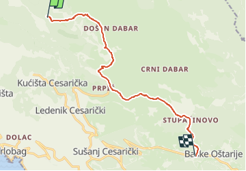
Tocht Te voet van 11,8 km beschikbaar op Onbekend, Ličko-senjska županija. Deze tocht wordt voorgesteld door SityTrail - itinéraires balisés pédestres.

Beschrijving

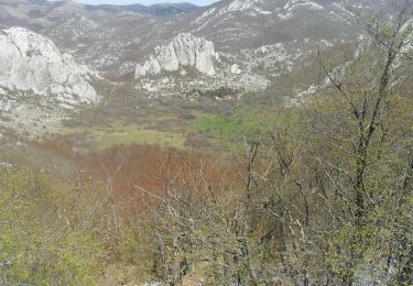
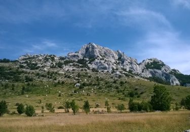
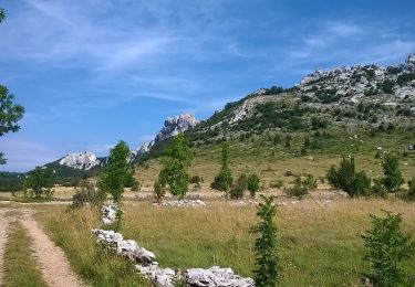
Unlike the section of central Velebit to the north, which is higher, but also characterized by grassland peaks with gentle terrain, the continuation of this ridge from Bačić kuk to Ljubičko brdo above Oštarije is completely different. Here, as in no other place in the area, we come across an ...

Website: https://trail.viadinarica.com/tour/hiking/15957781/

Hoogteprofiel

Foto's

Plaatsbepaling

Land:
Croatia
Regio :
Onbekend
Departement/Provincie :
Ličko-senjska županija
Gemeente :
Unknown
Locatie:
Unknown
Vertrek:(UTM)
507357 ; 4935863 (33T) N.

Wandeltochten in de omgeving

Tocht Te voet  - Bačić kuk iz Ravnog Dabra preko Bačić dulibe i Ripinovca - Photo
Te voet
GUIDE+

Te voet

Gemakkelijk
, Onbekend, Ličko-senjska županija, Croatia
4,7 km | 7,2 km-effort
1h 37min
Neen
Tocht Te voet  - Dabarska Kosa - Photo
Te voet
GUIDE+

Te voet

Gemakkelijk
, Onbekend, Ličko-senjska županija, Croatia
7 km | 10 km-effort
2h 16min
Neen
Tocht Te voet  - Ravni dabar do Alaginca preko Crnog dabra - Photo
Te voet
GUIDE+

Te voet

Gemakkelijk
, Onbekend, Ličko-senjska županija, Croatia
4,9 km | 11,4 km-effort
2h 34min
Neen
Tocht Te voet  - Grebenski put kroz Dabarske kukove - Photo
Te voet
GUIDE+

Te voet

Gemakkelijk
, Onbekend, Ličko-senjska županija, Croatia
4 km | 7,4 km-effort
1h 40min
Neen
Tocht Te voet  - Od magistrale do Premužićeve staze (Splovine) preko Radlovca - Photo
Te voet
GUIDE+

Te voet

Gemakkelijk
, Onbekend, Ličko-senjska županija, Croatia
9,1 km | 13,1 km-effort
2h 58min
Neen
Tocht Te voet  - Kugina kuća od Premužićeve staze kod Skorpovca - Photo
Te voet
GUIDE+

Te voet

Gemakkelijk
, Onbekend, Ličko-senjska županija, Croatia
4,3 km | 7,5 km-effort
1h 42min
Neen


Sluiten
Mijn abonnementen