Tocht Te voet Unknown - Spojni put Kapela - Velebit - Photo

Tous les sentiers balisés d’Europe GUIDE+

© OpenStreetMap contributors
Lengte
Lengte
25 km
Max. hoogte
Max. hoogte
1090 m
Positief hoogteverschil
822 m
Km-Effort
Km-Effort  
36 km
Min. hoogte
Min. hoogte
695 m
Negatief hoogteverschil
996 m
Boucle
Boucle
Neen
Markering
Markering
Datum van aanmaak :
2025-02-07 16:05:48.435
Laatste wijziging :
2025-02-07 16:05:48.435

(0 Bericht)

Te voet
Te voet
8h15
Moeilijkheid : Moeilijk

Scan deze QR-code om de tocht te openen in de SityTrail-applicatie

Gratisgps-wandelapplicatie

Logo SityTrail SityTrail

IGN / Geografische instituten

SityTrail uit de App Store downloaden SityTrail uit Google Play downloaden

Logo SityTrail SityTrail World

De wereld gaat voor u open

SityTrail uit de App Store downloaden SityTrail uit Google Play downloaden SityTrail op Huawei AppGallery downloaden

Over ons

Tocht Te voet van 25 km beschikbaar op Onbekend, Primorsko-goranska županija. Deze tocht wordt voorgesteld door SityTrail - itinéraires balisés pédestres.

Beschrijving

The most interesting phenomenon in this route stage is the group of rocks called Kolovratske stijene, offering a wonderful view towards the sea. The rocks of Kolovratske stijene extend south of the group of Samarske stijene and Bijele stijene, as a solitary ridge on the very edge of Velika ...

Website: https://trail.viadinarica.com/tour/hiking/15957274/

Hoogteprofiel

Foto's

Plaatsbepaling

Land:
Croatia
Regio :
Onbekend
Departement/Provincie :
Primorsko-goranska županija
Gemeente :
Unknown
Locatie:
Unknown
Vertrek:(UTM)
494700 ; 4998548 (33T) N.

Wandeltochten in de omgeving

Tocht Te voet  - Kapelskim planinarskim putom prema moru - Photo
Te voet
GUIDE+

Te voet

Medium
, Onbekend, Primorsko-goranska županija, Croatia
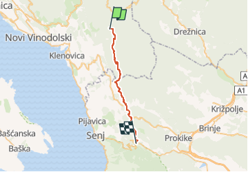
11,8 km | 21 km-effort
4h 41min
Neen


Sluiten
Mijn abonnementen